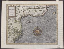
Norumbega et Virginia, 1597
- Title
- Norumbega et Virginia, 1597
- Description
- [Douai] : [Chez François Fabri], [1607?]. 1 map : color. Scale [ca. 1:5,000,000]. Covers coast from R. Primero in the north to Buelta de Arenas in the south. Relief shown pictorially. Shows rivers and Native American settlements. In Latin. Detached from: Histoire universelle des Indes orientales et occidentales / C. Wytfliet. Douay, 1605 (2d ed. 1607), no. 17. "17"--Upper right corner. Map framed. Date approximated. [Note from Conservation: map depicts the mythical city of "Norumbega," which is featured on many early maps. Originally spelled "Oranbega" in Verrazzano's 1529 map of America. Ortelius' 1570 map of America and here Wytfilet use the later spelling "Norumbega."]
- Extent
- 276cm x 361cm
- Local Identifier
- MC0028
- Permalink
- https://digital.lib.ecu.edu/62535
- Preferred Citation
- Cite this item
- This item
-
 Norumbega et Virginia, 1597
- My Collections Login
- Printable Feedback Form
Related Search Results

Public access is provided to these resources to preserve the historical record. The content represents the opinions and actions of their creators and the culture in which they were produced. Therefore, some materials may contain language and imagery that is outdated, offensive and/or harmful. The content does not reflect the opinions, values, or beliefs of ECU Libraries.
Contact Digital Collections
If you know something about this item or would like to request additional information, click here.
Comment on This Item
Complete the fields below to post a public comment about the material featured on this page. The email address you submit will not be displayed and would only be used to contact you with additional comments or questions.