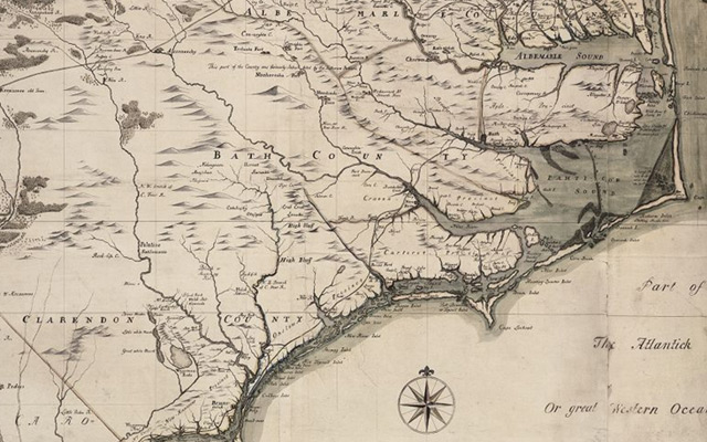
Carte de la Caroline et Georgie pour servir a l'hist. générale des voyages / tirée des auteurs anglois par M.B., Ing. de la marine ; A. v. Krevelt, sculpsit.
- Title
- Carte de la Caroline et Georgie pour servir a l'hist. générale des voyages / tirée des auteurs anglois par M.B., Ing. de la marine ; A. v. Krevelt, sculpsit.
- Description
- Amsteldam : , 1773. 1 map : col. Scale [ca. 1,3,800,000]. Relief shown pictorially. Second state, included in Histoire générale des voyages (Amsterdam : Chez E. van Harrevelt & D.J. Changuion, 1774), Tome 21. Copied from the Bellin 1757 map. Cf. Cumming. Southeast in early maps, 444.; At head: "Tom. XXI.". Map framed.
- Date
- 1773
- Original Format
- maps
- Extent
- 27cm x 18cm
- Local Identifier
- MC0002-006
- Creator(s)
- Contributor(s)
- Subject(s)
- Georgia--Maps--Early works to 1800
- South Carolina--Maps--Early works to 1800
- North Carolina--Maps--Early works to 1800
- Spatial
- Location of Original
- Special Collections Maps
- Rights
-
This item has been made available for use in research, teaching, and private study. Researchers are responsible for using these materials in accordance with Title 17 of the United States Code and any other applicable statutes. If you are the creator or copyright holder of this item and would like it removed, please contact us at als_digitalcollections@ecu.edu.
http://rightsstatements.org/vocab/InC-EDU/1.0/ - Permalink
- https://digital.lib.ecu.edu/10386
- Preferred Citation
- Cite this item
- This item
-
 Carte de la Caroline et Georgie pour servir a l'hist. générale des voyages / tirée des auteurs anglois par M.B., Ing. de la marine ; A. v. Krevelt, sculpsit.
- My Collections Login
- Printable Feedback Form
- Found in theme/project
-
 North Carolina Maps
- Location of Original
- Tillie V. Rodgers Map Collection: Partie méridionale de la Louisiane, avec la Floride, la Caroline et la Virginie / par le Sr. d'Anville. from the Special Collections Maps
Related Search Results
![Virginiae partis australis, et Floridae partis orientalis, interjacentiumq[ue] regionum, nova descriptio](https://iiif.lib.ecu.edu/cantaloupe/iiif/2/00010393_0001.jp2/full/!225,225/0/default.jpg)
Public access is provided to these resources to preserve the historical record. The content represents the opinions and actions of their creators and the culture in which they were produced. Therefore, some materials may contain language and imagery that is outdated, offensive and/or harmful. The content does not reflect the opinions, values, or beliefs of ECU Libraries.
Contact Digital Collections
If you know something about this item or would like to request additional information, click here.
Comments
oops, forgot to add... The title differs between the first and second states. On the first state of the map, the line below ET GEORGIE reads "pour servir à l'Hist. des Etablissements Europeens"
This is the 2nd state of the map and it was included in Histoire Generale Des Voyages.... , published by Harrevelt and Changuion in Amsterdam in 1774. The 2nd state has "Tom. XXI" at top right, just above neat line. This is lacking on the first state. The small "40" just inside the bottom right corner of the plate mark on the first state was erased for the second state. The first state was included in Atlas Portatif Pour Servir À L'Intelligence De L'Histoire Philosophique Et Politique Des Etablissemens Et Du Commerce Des Europe'ens Dans Les Deux Indes, published in 1773, also by Harrevelt and Changuion. This map was copied from Bellin's 1757 map of the same title.
Comment on This Item
Complete the fields below to post a public comment about the material featured on this page. The email address you submit will not be displayed and would only be used to contact you with additional comments or questions.
I am a staff member in Special Collections and I want to thank you for the extra information regarding this map. I have added it to the finding aid at https://digital.lib.ecu.edu/special/ead/findingaids/MC0002-006.