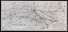
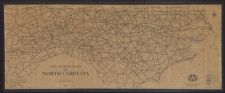
North Carolina highway system map
- Title
- North Carolina highway system map
- Description
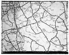
- Oversized map of the proposals of James G.W. MacLamroc, Greensboro, N.C., North Carolina State Highway Commissioner, Seventh Division. Shows approved and proposed highways, including a proposed seashore highway along the Outer Banks, "to be connected, first by ferries from island to island, and eventually, by bridges." Shows military bases. Map compiled 1961-1962.
- Date
- 1962
- Original Format
- maps
- Extent
- 124cm x 55cm
- Local Identifier
- 0268-s3-ss5-sss2-b223-fe
- Creator(s)
- Subject(s)
- Spatial
- Location of Original
- East Carolina Manuscript Collection
- Rights
-
This item has been made available for use in research, teaching, and private study. Researchers are responsible for using these materials in accordance with Title 17 of the United States Code and any other applicable statutes. If you are the creator or copyright holder of this item and would like it removed, please contact us at als_digitalcollections@ecu.edu.
http://rightsstatements.org/vocab/InC-EDU/1.0/ - Permalink
- https://digital.lib.ecu.edu/56733
- Preferred Citation
- Cite this item
- This item
-
 North Carolina highway system map
- My Collections Login
- Printable Feedback Form
- Found in theme/project
-
 Transportation
-
 Senator Robert Burren Morgan
-
 Transportation: Auto
- Location of Original
- Robert Morgan Papers from the East Carolina Manuscript Collection
- View all digitized items from the Robert Morgan Papers
Related Search Results

Public access is provided to these resources to preserve the historical record. The content represents the opinions and actions of their creators and the culture in which they were produced. Therefore, some materials may contain language and imagery that is outdated, offensive and/or harmful. The content does not reflect the opinions, values, or beliefs of ECU Libraries.
Contact Digital Collections
If you know something about this item or would like to request additional information, click here.
Comment on This Item
Complete the fields below to post a public comment about the material featured on this page. The email address you submit will not be displayed and would only be used to contact you with additional comments or questions.