Highway map
- Title
- Highway map
- Description
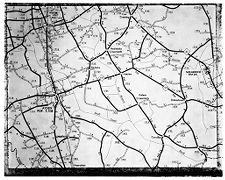
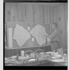
- Map showing Pitt county areas for road improvement. Date from negative sleeve.
- Date
- September 12, 1962
- Original Format
- negatives
- Extent
- 12cm x 10cm
- Local Identifier
- 0741-b28-fc-v28.c.17
- Contributor(s)
- Subject(s)
- Spatial
- Location of Original
- East Carolina Manuscript Collection
- Rights
-
Copyright held by East Carolina University. Permission to reuse this work is granted for all non-commercial purposes.
http://rightsstatements.org/vocab/InC-NC/1.0/ - Permalink
- https://digital.lib.ecu.edu/1840
- Preferred Citation
- Cite this item
- This item
-
 Highway map
- My Collections Login
- Printable Feedback Form
- is part of
-
 Sleeve 17, Folder c, Box 28
- Found in theme/project
-
 Daily Reflector Images
-
 North Carolina Maps
-
 Transportation
- Location of Original
- Daily Reflector Negative Collection from the East Carolina Manuscript Collection
- View all digitized items from the Daily Reflector Negative Collection
Related Search Results


Public access is provided to these resources to preserve the historical record. The content represents the opinions and actions of their creators and the culture in which they were produced. Therefore, some materials may contain language and imagery that is outdated, offensive and/or harmful. The content does not reflect the opinions, values, or beliefs of ECU Libraries.
Contact Digital Collections
If you know something about this item or would like to request additional information, click here.
Comments
Comment on This Item
Complete the fields below to post a public comment about the material featured on this page. The email address you submit will not be displayed and would only be used to contact you with additional comments or questions.
The "laddered/segmented" lines on map represent dirt roads, which were abundant at the time. Most have been paved now.