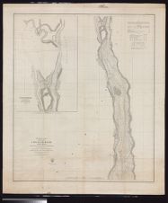
Preliminary chart of lower part of Cape Fear River, North Carolina from near Federal Point to Wilmington /from a trigonometrical survey under the direction of A.D. Bache, Superintendant of the Survey of the Coast of the United States ; triangulation and topography by C.P. Bolles ; hydrography by the party under the command of Lieut. J.N. Maffitt ...
- Title
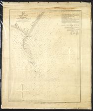
- Preliminary chart of lower part of Cape Fear River, North Carolina from near Federal Point to Wilmington /from a trigonometrical survey under the direction of A.D. Bache, Superintendant of the Survey of the Coast of the United States ; triangulation and topography by C.P. Bolles ; hydrography by the party under the command of Lieut. J.N. Maffitt ...
- Description
- Washington : U.S. Coast Survey, 1856. 1 map. Scale 1:30,000(W 78°05'33--W 77°53'14/N 34°12'47--N 34°00'22). Depth shown by soundings and isolines.; "Redd. drng. by F.D. Stewart & F. Fairfax" ; "Engd. by J.V.N. Throop & A.M. Maedel."; "No. 425."NcGrE; Includes charts of lighthouses and tides.; Inset: Cape Fear River in the vicinity of Wilmington. Scale 1:20,000.U.S. Coast Survey
- Date
- 1856
- Extent
- 74cm x 86cm
- Local Identifier
- G3902.C16 P5 1856 .U67
- Creator(s)
- Contributor(s)
- Subject(s)
- Cape Fear River (N.C.)--Maps
- Cape Fear River (N.C.)--Navigation
- Nautical charts--North Carolina--Cape Fear River
- Permalink
- https://digital.lib.ecu.edu/10474
- Preferred Citation
- Cite this item
- This item
-
 Preliminary chart of lower part of Cape Fear River, North Carolina from near Federal Point to Wilmington /from a trigonometrical survey under the direction of A.D. Bache, Superintendant of the Survey of the Coast of the United States ; triangulation and topography by C.P. Bolles ; hydrography by the party under the command of Lieut. J.N. Maffitt ...
- My Collections Login
- Printable Feedback Form
- Found in theme/project
-
 North Carolina Maps
Related Search Results
Public access is provided to these resources to preserve the historical record. The content represents the opinions and actions of their creators and the culture in which they were produced. Therefore, some materials may contain language and imagery that is outdated, offensive and/or harmful. The content does not reflect the opinions, values, or beliefs of ECU Libraries.
Contact Digital Collections
If you know something about this item or would like to request additional information, click here.
Comment on This Item
Complete the fields below to post a public comment about the material featured on this page. The email address you submit will not be displayed and would only be used to contact you with additional comments or questions.