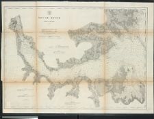
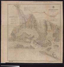
Neuse River, North Carolina.
- Title
- Neuse River, North Carolina.
- Description
- Washington : U.S. Coast Survey, 1874. 1 map. Scale 1:80,000(W 76°57'30--W 76°18'00/N 35°9'00--N 34°46'00). Depths shown by soundings and isolines.; "Issued August 1874 C.P. Patterson, Superintendent."; "No. 25." NcGrE; "The surveys for this chart were made under the direction of A.D. Bache and Benjamin Peirce, Superintendents of the Coast Survey between 1863 and 1872 ; triangulation by G.A. Fairfield between 1863 & 1872 ; topography by F.W. Dorr between 1866 & 1872 ; hydrography by J.S. Bradford and F.F. Nes between 1866 & 1870."; Includes chart of lighthouses.U.S. Coast Survey
- Date
- 1874
- Extent
- 86cm x 63cm
- Local Identifier
- G3902.N4 P5 1874 .U67
- Creator(s)
- Contributor(s)
- Subject(s)
- Neuse River (N.C.)--Maps
- Neuse River (N.C.)--Navigation
- Nautical charts--North Carolina--Neuse River
- Permalink
- https://digital.lib.ecu.edu/10464
- Preferred Citation
- Cite this item
- This item
-
 Neuse River, North Carolina.
- My Collections Login
- Printable Feedback Form
- Found in theme/project
-
 North Carolina Maps
Related Search Results
Public access is provided to these resources to preserve the historical record. The content represents the opinions and actions of their creators and the culture in which they were produced. Therefore, some materials may contain language and imagery that is outdated, offensive and/or harmful. The content does not reflect the opinions, values, or beliefs of ECU Libraries.
Contact Digital Collections
If you know something about this item or would like to request additional information, click here.
Comment on This Item
Complete the fields below to post a public comment about the material featured on this page. The email address you submit will not be displayed and would only be used to contact you with additional comments or questions.