Themes & Projects
Browse
All Items
Divisions
Subjects
My Collections
Themes & Projects
About
Advanced Search
Help us improve our site.
Please take our survey
!
Digital Collections User Survey
×
Loading…
Home
Filtered search
FILTER SEARCH
Exclude Born Digital Content
DATE RANGE
to
Limit
ONLINE FORMAT
Image
59
ORIGINAL FORMAT
maps
24
negatives
9
ORIGINAL FORMAT
×
ORIGINAL FORMAT
COUNT
maps
24
negatives
9
LOCATION
Greenville (N.C.)
9
Pitt County (N.C.)
4
North Carolina
3
Craven County (N.C.)
1
Elizabeth City (N.C.)
1
Perquimans County (N.C.)
1
South Carolina
1
LOCATION
×
LOCATION
COUNT
Greenville (N.C.)
9
Pitt County (N.C.)
4
North Carolina
3
Craven County (N.C.)
1
Elizabeth City (N.C.)
1
Perquimans County (N.C.)
1
South Carolina
1
THEME/PROJECT
North Carolina Maps
Daily Reflector Images
12
Military History
6
Military History: Marines
5
Politics and Government
4
Politics and Government: North Carolina
4
Transportation
3
More
THEME/PROJECT
×
THEME/PROJECT
COUNT
North Carolina Maps
59
Daily Reflector Images
12
Military History
6
Military History: Marines
5
Politics and Government
4
Politics and Government: North Carolina
4
Transportation
3
Agriculture
2
Early American History
2
Military History: Civil War
1
Natural Disasters
1
North Carolina History and Fiction Collection
1
Social and Family Life
1
Transportation: Auto
1
SUBJECT
Greenville (N.C.)--Maps
8
Drainage--North Carolina--Greenville
2
Election districts--North Carolina--Greenville--Maps
2
North Carolina--Maps--Early works to 1800
2
Pitt County (N.C.)--Maps
2
Tar River Watershed (Person County-Beaufort County, N.C.)--Maps
2
Automobile parking--Law and legislation--North Carolina--Greenville
1
More
SUBJECT
×
SUBJECT
COUNT
Greenville (N.C.)--Maps
8
Drainage--North Carolina--Greenville
2
Election districts--North Carolina--Greenville--Maps
2
North Carolina--Maps--Early works to 1800
2
Pitt County (N.C.)--Maps
2
Tar River Watershed (Person County-Beaufort County, N.C.)--Maps
2
Automobile parking--Law and legislation--North Carolina--Greenville
1
Battlefields--North Carolina--Maps
1
Boy Scouts--North Carolina--Greenville
1
Camping--North Carolina--Greenville
1
Coasts--North Carolina--Maps--Early works to 1800
1
Conetoe Creek (N.C.)--Maps
1
Contentnea Creek (N.C.)--Maps
1
Craven County (N.C.)--Maps
1
Election districts--North Carolina--Greenville
1
Elizabeth City (N.C.)--Maps
1
Fortification--North Carolina--Maps
1
Harbors--South Carolina--Beaufort--Maps--Early works to 1800
1
Harbors--South Carolina--Charleston--Maps--Early works to 1800
1
Kiwanis International
1
Landowners--North Carolina--Craven County
1
Marine Corps Air Station Cherry Point (N.C.)--Maps
1
North Carolina--Administrative and political divisions--Maps--Early works to 1800
1
North Carolina--History--Civil War, 1861-1865
1
Perquimans County (N.C.)--Maps
1
Real property--North Carolina--Craven County--Maps
1
Roads--North Carolina--Pitt County
1
Sea Islands--Maps--Early works to 1800
1
South Carolina--Administrative and political divisions--Maps--Early works to 1800
1
South Carolina--Maps--Early works to 1800
1
Streets--North Carolina--Greenville
1
United States--History--Civil War, 1861-1865--Campaigns
1
Urban renewal--North Carolina--Greenville
1
DIVISION
East Carolina Manuscript Collection
22
Joyner NC Maps
8
Joyner NC Maps Oversize
1
Joyner NC Rare
1
Joyner NC Stacks
1
DIVISION
×
DIVISION
COUNT
East Carolina Manuscript Collection
22
Joyner NC Maps
8
Joyner NC Maps Oversize
1
Joyner NC Rare
1
Joyner NC Stacks
1
Filters
Search Results
59 results found for:
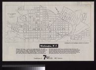
fullsubject:Farmville (N.C.) History
Theme/Project:
North Carolina Maps
Sort by:
Relevance
Date Digitized
Date Created
View all
North Carolina Maps
material.
Currently viewing items 1 - 40
PAGE
OF 2
Next
Elizabeth City, N.C.
Map of Greenville, N.C.
Plan of Greenville, N.C., 1885
Goldsboro, Wayne Co., N.C.
Map of Perquimans County, N.C., 1877
Shaffer's map of Wake County, N.C.
Washington, N.C. distributed by the Washington Cha...
Washington N.C. /surveyed and drawn by J.W. Johnso...
Map showing the forts, towns and battlefields ment...
Map of Gaston County, N.C. showing rural delivery ...
Map of Greenville, N.C. : population 1930-10,168, ...
Ownership map of proposed Cherry Point Marine Avia...
Winston-Salem, North Carolina
Map of the city of Greenville, N.C. : our Greenvil...
Map town of Plymouth, N.C., showing city limits /W...
Power map of North Carolina prepared by N.C. Depar...
James Wimble's 1738 Map of North Carolina
Eastern Craven County and Carteret County North Ca...
Map of the town of Asheboro, North Carolina, chart...
Map of North Carolina showing location of water sa...
Mouzon Map (1775)
Map of North Carolina showing stream gaging statio...
Map showing gaging stations and undeveloped water-...
Burlington, North Carolina the ideal industrial ce...
Stock law map of North Carolina compiled from data...
City of Greenville : county seat of Pitt County, N...
Mount Olive, N. C. / C. Beems.
Carteret County North Carolina State Highway and P...
City of Greenville, Pitt County, North Carolina.
Lenoir County North Carolina State Highway and Pub...
Street map of Shelby, North Carolina drawn by Dean...
Zone map, town of Asheboro, North Carolina Harold ...
Map of the city of New Bern, North Carolina prepar...
Map of the city of New Bern, North Carolina drawn ...
Map of Wake County drawn from actual surveys /by F...
City map of Roanoke Rapids, North Carolina : inclu...
City of Raleigh, North Carolina prepared by Air Su...
City map of Roanoke Rapids, North Carolina includi...
Currently viewing items 1 - 40
PAGE
OF 2
Next