Map of the town of Asheboro, North Carolina, chartered in 1796 survey and map by R.D. Trogdon, engineer, Ashboro, N.C.
- Title
- Map of the town of Asheboro, North Carolina, chartered in 1796 survey and map by R.D. Trogdon, engineer, Ashboro, N.C.
- Description
- Asheboro, N.C. : , 1937. 1 map. Scale [1:2400]. 1 in. = 200 ft. Inset map: Town of Asheboro, N.C., 1843.; "January, 1936. Revised Aug. 1937."; "3, 1961 acres, elevation 846.71.".
- Date
- 1937
- Extent
- Local Identifier
- G3904.A7G46 1937 T76
- Creator(s)
- Subject(s)
- Permalink
- https://digital.lib.ecu.edu/10417
- Preferred Citation
- Cite this item
- This item
-
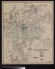 Map of the town of Asheboro, North Carolina, chartered in 1796 survey and map by R.D. Trogdon, engineer, Ashboro, N.C.
- My Collections Login
- Printable Feedback Form
- Found in theme/project
-
 North Carolina Maps
Related Search Results

Public access is provided to these resources to preserve the historical record. The content represents the opinions and actions of their creators and the culture in which they were produced. Therefore, some materials may contain language and imagery that is outdated, offensive and/or harmful. The content does not reflect the opinions, values, or beliefs of ECU Libraries.
Contact Digital Collections
If you know something about this item or would like to request additional information, click here.
Comment on This Item
Complete the fields below to post a public comment about the material featured on this page. The email address you submit will not be displayed and would only be used to contact you with additional comments or questions.