Zee en Land - Togten der Franszen Gedaan na, en in't Americaans Gewest van Florida
- Title
- Zee en Land - Togten der Franszen Gedaan na, en in't Americaans Gewest van Florida
- Description
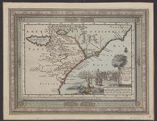
- Zee en Land - Togten der Franszen Gedaan na, en in't Americaans Gewest van Florida, aller-eerst door Ioh. Pontius Ontdekt : voyages par Mer et par Terre des François dans la Floride, prémierement découverte par Jean Pontius / dressez sur les Mémoires, et perfectionez par un grand nombre d'autres plus recens, de nouveau mis au jour par Pierre vander Aa, á Leide, Avec Privilege. 1 map : color ; 15 x 22 cm. [Leyden : Pieter Vander Aa, 1714?]. Estimated date from Cumming, The Southeast in early maps. Relief is shown pictorially. Title in cartouche at lower right, surrounded by scenes of sailing ships, explorers arriving on shore, and explorers fighting Indians. Includes ornamental border. In lower right corner, under map: 107. From Aa, Pieter van der. Atlas nouveau. Leide, [1714], II, no. 31. Cf. Cumming.
- Date
- 1714
- Original Format
- maps
- Extent
- 31cm x 24cm
- Local Identifier
- MC0049
- Creator(s)
- Subject(s)
- Florida--Maps--Early works to 1800
- South Atlantic States--Maps--Early works to 1800
- South Carolina--Maps--Early works to 1800
- North Carolina--Maps--Early works to 1800
- Spatial
- Location of Original
- East Carolina Manuscript Collection
- Rights
-
This item has been made available for use in research, teaching, and private study. Researchers are responsible for using these materials in accordance with Title 17 of the United States Code and any other applicable statutes. If you are the creator or copyright holder of this item and would like it removed, please contact us at als_digitalcollections@ecu.edu.
http://rightsstatements.org/vocab/InC-EDU/1.0/ - Permalink
- https://digital.lib.ecu.edu/27448
- Preferred Citation
- Cite this item
- This item
- Zee en Land - Togten der Franszen Gedaan na, en in't Americaans Gewest van Florida
- My Collections Login
- Printable Feedback Form
- Found in theme/project
-
 North Carolina Maps
- Location of Original
- Zee en Land - Togten der Franszen Gedaan na, en in't Americaans Gewest van Florida, aller-eerst door Ioh. Pontius Ontdekt : voyages par Mer et par Terre des François dans la Floride, prémierement découverte par Jean Pontius / dressez sur les Mémoires, et perfectionez par un grand nombre d'autres plus recens, de nouveau mis au jour par Pierre vander Aa, á Leide, Avec Privilege. from the East Carolina Manuscript Collection
- View all digitized items from the Zee en Land - Togten der Franszen Gedaan na, en in't Americaans Gewest van Florida, aller-eerst door Ioh. Pontius Ontdekt : voyages par Mer et par Terre des François dans la Floride, prémierement découverte par Jean Pontius / dressez sur les Mémoires, et perfectionez par un grand nombre d'autres plus recens, de nouveau mis au jour par Pierre vander Aa, á Leide, Avec Privilege.
Related Search Results

Public access is provided to these resources to preserve the historical record. The content represents the opinions and actions of their creators and the culture in which they were produced. Therefore, some materials may contain language and imagery that is outdated, offensive and/or harmful. The content does not reflect the opinions, values, or beliefs of ECU Libraries.
Contact Digital Collections
If you know something about this item or would like to request additional information, click here.
Comments
Comment on This Item
Complete the fields below to post a public comment about the material featured on this page. The email address you submit will not be displayed and would only be used to contact you with additional comments or questions.
This 1706 map of the Carolinas and Florida drawn by Pieter van der Aa (1659-1733) is based on an earlier 1606 map by Hondius (see MC 42). The map features a North Carolina Native American town called Chicola on the River Jordaan. Also shown are the locations of the ill fated French settlements of 1562 (Ribaut) and 1564 (Laudonierre). The lower right cartouche features a really neat early European drawing of the Carolina Palmetto (Sabal Palmetto). The title of the map Zee en Land togten der Franszen na,en in’t Americaans Gewest van Florida, aller-eerst dour Joh. Pontius ontdekt, translates as the land of France in America along with the discoveries of Ponce de Leon.