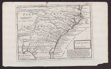
Carolina
- Title
- Carolina
- Description
- [note from Conservator: According to William P. Cumming's "The Southeast in Early Maps" the image is from Samuel Simpson's The agreeable historian. London, 1746, v. 3. Has anyone checked if Cumming is correct or is there a reason a NC map was included in a geographical description of the non-colonial parts of the UK? The title page of Volume 3 of "The Agreeable Historian" indicates that it is specifically related to counties starting with Norfolk and ending with Yorkshire in England located on the Isle of Great Britain. http://www.lakesguides.co.uk/large/smp3it.jpg . Volume 1 was Bedfordshire to Essex, and Vol 2 was Gloucestershire to Middlesex. It seems odd, but I know stranger things have happened. Sadly, I could only find volumes 1 &2 on the ECCO database]
- Extent
- 235cm x 385cm
- Local Identifier
- MC0002-004
- Permalink
- https://digital.lib.ecu.edu/62527
- Preferred Citation
- Cite this item
- This item
-
 Carolina
- My Collections Login
- Printable Feedback Form
Related Search Results

Public access is provided to these resources to preserve the historical record. The content represents the opinions and actions of their creators and the culture in which they were produced. Therefore, some materials may contain language and imagery that is outdated, offensive and/or harmful. The content does not reflect the opinions, values, or beliefs of ECU Libraries.
Contact Digital Collections
If you know something about this item or would like to request additional information, click here.
Comment on This Item
Complete the fields below to post a public comment about the material featured on this page. The email address you submit will not be displayed and would only be used to contact you with additional comments or questions.