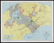
The Panama Canal : Map of the Canal Zone and vicinity
- Title
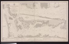
- The Panama Canal : Map of the Canal Zone and vicinity
- Description
- 1 color map. Scale 1:100,000. (W 80°05'00"--W 79°20'00"/N 9°25'00"--N 8°50'00"). Compiled by Section of Office Engineer and Section of Surveys, Panama Canal. Original compiled January, 1927. Revisions and additions made ... July 1973. Series E661, Edition 6-DMATC. Relief shown by hachures and spot heights. Maps shows roads, lighthouses, and natural features. Insets: Madden Lake Watershed -- Republic of Panama.
- Date
- July 1973
- Original Format
- maps
- Extent
- 99cm x 79cm
- Local Identifier
- 0268-s4-ss5-sss3-b392-fa-i1
- Subject(s)
- Spatial
- Location of Original
- East Carolina Manuscript Collection
- Rights
-
This item has been made available for use in research, teaching, and private study. Researchers are responsible for using these materials in accordance with Title 17 of the United States Code and any other applicable statutes. If you are the creator or copyright holder of this item and would like it removed, please contact us at als_digitalcollections@ecu.edu.
http://rightsstatements.org/vocab/InC-EDU/1.0/ - Permalink
- https://digital.lib.ecu.edu/56832
- Preferred Citation
- Cite this item
- This item
-
 The Panama Canal : Map of the Canal Zone and vicinity
- My Collections Login
- Printable Feedback Form
- Found in theme/project
-
 Transportation
-
 Senator Robert Burren Morgan
-
 Transportation: Water
- Location of Original
- Robert Morgan Papers from the East Carolina Manuscript Collection
- View all digitized items from the Robert Morgan Papers
Related Search Results
Public access is provided to these resources to preserve the historical record. The content represents the opinions and actions of their creators and the culture in which they were produced. Therefore, some materials may contain language and imagery that is outdated, offensive and/or harmful. The content does not reflect the opinions, values, or beliefs of ECU Libraries.
Contact Digital Collections
If you know something about this item or would like to request additional information, click here.
Comments
Comment on This Item
Complete the fields below to post a public comment about the material featured on this page. The email address you submit will not be displayed and would only be used to contact you with additional comments or questions.
This is an amazing map! However, the link to download the biggest image size for it is broken. 500 Internal Server Error. It's the one which is 11965 x 9663px