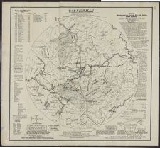
Waynesville and its vicinity within radius twenty-five miles issued by the Waynesville Factory Site and Electric Power Company ; from the U. S. Government Geological Survey ; compilation of data under the direction of S.A. Jones ; J.N. Schoolbred, delineator.
- Title
- Waynesville and its vicinity within radius twenty-five miles issued by the Waynesville Factory Site and Electric Power Company ; from the U. S. Government Geological Survey ; compilation of data under the direction of S.A. Jones ; J.N. Schoolbred, delineator.
- Description
- Waynesville, N.C. : Waynesville Factory Site and Electric Power Co., 1905. 1 map. Scale ca. 1:126,720. Relief shown by contours and spot heights.; "Copyrighted June 26, 1905 by S.A. Jones, Waynesville, N.C."; "This map shows the Waynesville Valley to be absolutely protected from cyclones and floods."; Shows natural features, roads, railroads, and lists of timber.Waynesville Factory Site and Electric Power Co.
- Date
- 1905
- Extent
- 91cm x 84cm
- Local Identifier
- G3904.W33 1905 .W39
- Creator(s)
- Contributor(s)
- Subject(s)
- Permalink
- https://digital.lib.ecu.edu/10816
- Preferred Citation
- Cite this item
- This item
-
 Waynesville and its vicinity within radius twenty-five miles issued by the Waynesville Factory Site and Electric Power Company ; from the U. S. Government Geological Survey ; compilation of data under the direction of S.A. Jones ; J.N. Schoolbred, delineator.
- My Collections Login
- Printable Feedback Form
- Found in theme/project
-
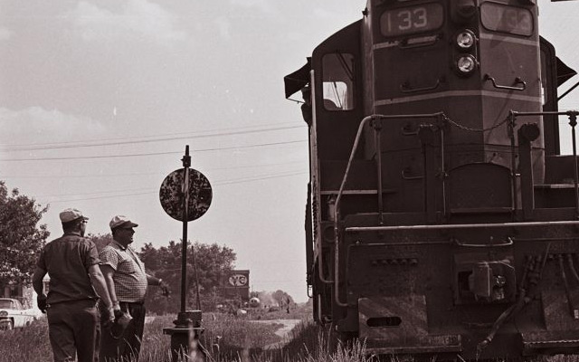 Transportation: Rail
Related Search Results

Public access is provided to these resources to preserve the historical record. The content represents the opinions and actions of their creators and the culture in which they were produced. Therefore, some materials may contain language and imagery that is outdated, offensive and/or harmful. The content does not reflect the opinions, values, or beliefs of ECU Libraries.
Contact Digital Collections
If you know something about this item or would like to request additional information, click here.
Comment on This Item
Complete the fields below to post a public comment about the material featured on this page. The email address you submit will not be displayed and would only be used to contact you with additional comments or questions.