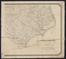
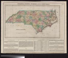
Map of North Carolina by W.C. Kerr ; assisted by Wm. Cain.
- Title
- Map of North Carolina by W.C. Kerr ; assisted by Wm. Cain.
- Description
- Raleigh, N.C. : Geological Survey of North Carolina; N.Y.; Julius Bien & Co., Lith, 1882. 1 map : hand col. Scale [1:633,600] ;Polyconic proj. (W 84°--W 76°/N 36°--N 34°). Relief shown by shading and spot heights.; "Constructed from original surveys and triangulations of the U.S. Coast and Geodetic Survey, of Prof. Guyot, of the state geologist, and of the U.S. engineers; and embodying the surveys made by the state from 1820 to date, of swamp lands, rail roads, rivers, canals and turnpikes; & also the surveys made by R.R., plank road, and other corporations, to date; and numerous county and land surveys."; "The map of a large part of the mountain region was plotted to scale, from his own triangulations, and furnished by hand, by Prof. A. Guyot of Princeton."; "Published under the authority of the State Board of Agriculture."; Includes population chart, statistics, and cartographic note. Library's copy imperfect? : Eastern North Carolina only (W 60°--W 76°/N 36°--N 34°), 60 x 67 cm. on sheet 69 x 76 cm.Geological Survey of North Carolina] :; N.Y. :; Julius Bien & Co., Lith
- Date
- 1882
- Extent
- 76cm x 69cm
- Local Identifier
- G3900 1882 .K3 1966
- Creator(s)
- Contributor(s)
- Cain, Wm. (William), 1847-1930
- Guyot, A. (Arnold), 1807-1884
- North Carolina Geological Survey (1883-1905)
- North Carolina. Board of Agriculture
- U.S. Coast and Geodetic Survey
- Subject(s)
- Permalink
- https://digital.lib.ecu.edu/10790
- Preferred Citation
- Cite this item
- This item
-
 Map of North Carolina by W.C. Kerr ; assisted by Wm. Cain.
- My Collections Login
- Printable Feedback Form
Related Search Results


Public access is provided to these resources to preserve the historical record. The content represents the opinions and actions of their creators and the culture in which they were produced. Therefore, some materials may contain language and imagery that is outdated, offensive and/or harmful. The content does not reflect the opinions, values, or beliefs of ECU Libraries.
Contact Digital Collections
If you know something about this item or would like to request additional information, click here.
Comment on This Item
Complete the fields below to post a public comment about the material featured on this page. The email address you submit will not be displayed and would only be used to contact you with additional comments or questions.