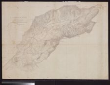
Portions of Murphy and Nantahalah sheets, North Carolina surveyed by Chas. E. Cooke, topog.
- Title
- Portions of Murphy and Nantahalah sheets, North Carolina surveyed by Chas. E. Cooke, topog.
- Description
- S.l. : U.S. Geological Survey, 1892. 1 map. Scale [1:63,360](W 84°03'19--W 83°40'00/N 35°15'31--N 35°00'00). Relief shown by contours.; Shows select towns and natural features, and railroad tracks.; Across center of map: "Cherokee" [i.e. Cherokee County, N.C.].U.S. Geological Survey
- Date
- 1892
- Extent
- Local Identifier
- G3902.N35 C2 1892 .G46
- Creator(s)
- Contributor(s)
- Subject(s)
- Permalink
- https://digital.lib.ecu.edu/10471
- Preferred Citation
- Cite this item
- This item
-
 Portions of Murphy and Nantahalah sheets, North Carolina surveyed by Chas. E. Cooke, topog.
- My Collections Login
- Printable Feedback Form
- Found in theme/project
-
 North Carolina Maps
Related Search Results

Public access is provided to these resources to preserve the historical record. The content represents the opinions and actions of their creators and the culture in which they were produced. Therefore, some materials may contain language and imagery that is outdated, offensive and/or harmful. The content does not reflect the opinions, values, or beliefs of ECU Libraries.
Contact Digital Collections
If you know something about this item or would like to request additional information, click here.
Comment on This Item
Complete the fields below to post a public comment about the material featured on this page. The email address you submit will not be displayed and would only be used to contact you with additional comments or questions.