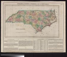
Geographical, statistical, and historical map of North Carolina drawn by F. Lucas, Jr. ; kneass, Sc.
- Title
- Geographical, statistical, and historical map of North Carolina drawn by F. Lucas, Jr. ; kneass, Sc.
- Description
- 1 map : hand col. Scale [ca. 1:1,650,000](W 84°--W 76°/N 37°--N 34°). Relief shown by hachures.; Prime meridians: London and Washington, D.C.; Accompanied by historical and descriptive text.; In upper right margin: "no. 23."; Probably map no. 23 of A complete historical, chronological, and geographical American atlas. Date approximated.
- Date
- 1822
- Extent
- Local Identifier
- G3900 1822 L8
- Creator(s)
- Contributor(s)
- Subject(s)
- Permalink
- https://digital.lib.ecu.edu/10451
- Preferred Citation
- Cite this item
- This item
-
 Geographical, statistical, and historical map of North Carolina drawn by F. Lucas, Jr. ; kneass, Sc.
- My Collections Login
- Printable Feedback Form
- Found in theme/project
-
 North Carolina Maps
Related Search Results
![Virginiae partis australis, et Floridae partis orientalis, interjacentiumq[ue] regionum nova descriptio](https://iiif.lib.ecu.edu/cantaloupe/iiif/2/00010394_0001.jp2/full/!225,225/0/default.jpg)
Public access is provided to these resources to preserve the historical record. The content represents the opinions and actions of their creators and the culture in which they were produced. Therefore, some materials may contain language and imagery that is outdated, offensive and/or harmful. The content does not reflect the opinions, values, or beliefs of ECU Libraries.
Contact Digital Collections
If you know something about this item or would like to request additional information, click here.
Comment on This Item
Complete the fields below to post a public comment about the material featured on this page. The email address you submit will not be displayed and would only be used to contact you with additional comments or questions.