Themes & Projects
Browse
All Items
Divisions
Subjects
My Collections
Themes & Projects
About
Advanced Search
Help us improve our site.
Please take our survey
!
Digital Collections User Survey
×
Loading…
Home
Filtered search
FILTER SEARCH
Exclude Born Digital Content
DATE RANGE
to
Limit
ONLINE FORMAT
Image
122
Text
15
Folder
1
ORIGINAL FORMAT
maps
52
financial records
15
negatives
11
ORIGINAL FORMAT
×
ORIGINAL FORMAT
COUNT
maps
52
financial records
15
negatives
11
LOCATION
Bladen County (N.C.)
14
Greenville (N.C.)
11
North Carolina
10
Pitt County (N.C.)
4
Fear, Cape (N.C.)
2
South Carolina
2
Bermuda Islands
1
More
LOCATION
×
LOCATION
COUNT
Bladen County (N.C.)
14
Greenville (N.C.)
11
North Carolina
10
Pitt County (N.C.)
4
Fear, Cape (N.C.)
2
South Carolina
2
Bermuda Islands
1
Black Mingo Creek (S.C.)
1
Craven County (N.C.)
1
Elizabeth City (N.C.)
1
Kitty Hawk (N.C.)
1
Maryland
1
Perquimans County (N.C.)
1
Virginia
1
THEME/PROJECT
North Carolina Maps
Daily Reflector Images
15
Military History
6
Politics and Government
6
Military History: Marines
5
Transportation: Rail
5
Politics and Government: North Carolina
4
More
THEME/PROJECT
×
THEME/PROJECT
COUNT
North Carolina Maps
138
Daily Reflector Images
15
Military History
6
Politics and Government
6
Military History: Marines
5
Transportation: Rail
5
Politics and Government: North Carolina
4
Transportation
4
Agriculture
2
Early American History
2
Special Collections Staff Picks
2
Military History: Civil War
1
Natural Disasters
1
North Carolina History and Fiction Collection
1
Social and Family Life
1
Transportation: Auto
1
SUBJECT
Deeds--North Carolina--Bladen County
14
Land tenure--North Carolina--Bladen County
14
Greenville (N.C.)--Maps
10
North Carolina--Maps--Early works to 1800
7
Beaufort (N.C.)--Maps--Early works to 1800
3
Cities and towns--North Carolina--Maps--Early works to 1800
3
Landowners--North Carolina--Maps--Early works to 1800
3
More
SUBJECT
×
SUBJECT
COUNT
Deeds--North Carolina--Bladen County
14
Land tenure--North Carolina--Bladen County
14
Greenville (N.C.)--Maps
10
North Carolina--Maps--Early works to 1800
7
Beaufort (N.C.)--Maps--Early works to 1800
3
Cities and towns--North Carolina--Maps--Early works to 1800
3
Landowners--North Carolina--Maps--Early works to 1800
3
Ocracoke Inlet (N.C.)--Maps--Early works to 1800
3
Smith, Thomas
3
Cape Fear River (N.C.)--Maps
2
Cape Fear River (N.C.)--Navigation
2
Drainage--North Carolina--Greenville
2
Election districts--North Carolina--Greenville--Maps
2
Fear, Cape (N.C.)--Maps
2
Fear, Cape (N.C.)--Maps--Early works to 1800
2
Herndon, William
2
McLellan, Andrew
2
Nautical charts--North Carolina--Cape Fear River
2
Pitt County (N.C.)--Maps
2
Rutherford, John
2
South Carolina--Maps--Early works to 1800
2
Tar River Watershed (Person County-Beaufort County, N.C.)--Maps
2
Atlantic Coast Lumber Company
1
Automobile parking--Law and legislation--North Carolina--Greenville
1
Battlefields--North Carolina--Maps
1
Bermuda Islands--Distances, etc.
1
Bermuda Islands--Maps--Early works to 1800
1
Black Mingo Creek (S.C.)--Maps
1
Boy Scouts--North Carolina--Greenville
1
Bradley, James
1
Camping--North Carolina--Greenville
1
Coasts--North Carolina
1
Coasts--North Carolina--Maps--Early works to 1800
1
Conetoe Creek (N.C.)--Maps
1
Contentnea Creek (N.C.)--Maps
1
Craven County (N.C.)--Maps
1
Dare County (N.C.)--Maps
1
Deeds--North Carolina
1
Election districts--North Carolina--Greenville
1
Elizabeth City (N.C.)--Maps
1
F. Rhem and Sons Company
1
Fortification--North Carolina--Maps
1
Fryingpan Shoals (N.C.)--Maps
1
Fryingpan Shoals (N.C.)--Navigation
1
Harbors--South Carolina--Beaufort--Maps--Early works to 1800
1
Harbors--South Carolina--Charleston--Maps--Early works to 1800
1
Harnett, Cornelius, 1723-1781
1
Harrison, William
1
Kitty Hawk (N.C.)--Maps
1
Kiwanis International
1
Land tenure--North Carolina
1
Land tenure--South Carolina
1
Landowners--North Carolina--Craven County
1
Marine Corps Air Station Cherry Point (N.C.)--Maps
1
Maryland--Maps--Early works to 1800
1
McCollum, Daniel
1
Nautical charts--North Carolina--Fryingpan Shoals
1
North Carolina--Administrative and political divisions--Maps--Early works to 1800
1
North Carolina--History--Civil War, 1861-1865
1
North Carolina--Maps
1
Perquimans County (N.C.)--Maps
1
Real property--North Carolina--Craven County--Maps
1
Roads--North Carolina--Pitt County
1
Roanoke Island (N.C.)--Distances, etc.
1
Sea Islands--Maps--Early works to 1800
1
Singletary, Thomson
1
South Carolina--Administrative and political divisions--Maps--Early works to 1800
1
Spaight, Richard Dobbs, 1758-1802
1
Streets--North Carolina--Greenville
1
Swann, Samuel, 1704-1774
1
U.S. Coast and Geodetic Survey
1
United States--History--Civil War, 1861-1865--Campaigns
1
Urban renewal--North Carolina--Greenville
1
Virginia--Maps--Early works to 1800
1
White, William, -1811
1
DIVISION
East Carolina Manuscript Collection
55
Joyner NC Maps
14
Special Collections Maps
2
Joyner NC Maps Oversize
1
Joyner NC Rare
1
Joyner NC Stacks
1
Joyner Rare
1
More
DIVISION
×
DIVISION
COUNT
East Carolina Manuscript Collection
55
Joyner NC Maps
14
Special Collections Maps
2
Joyner NC Maps Oversize
1
Joyner NC Rare
1
Joyner NC Stacks
1
Joyner Rare
1
University Archives
1
Filters
Search Results
138 results found for:
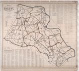
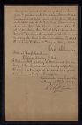
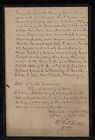
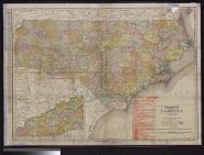
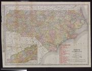
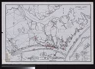
Deeds—North Carolina—Pitt County
Theme/Project:
North Carolina Maps
Sort by:
Relevance
Date Digitized
Date Created
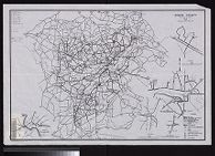
View all
North Carolina Maps
material.
Currently viewing items 1 - 40
PAGE
OF 4
Next
City of Greenville, Pitt County, North Carolina.
City of Greenville : county seat of Pitt County, N...
Map of New Hanover County, North Carolina.
Map of Pitt County
Map of the county of Halifax, North Carolina, 1914...
Cornelius Harnett. Copy of Deed and Survey
A Plan of the Town & Port of Edenton in Chowan Co...
Samuel Swann. Copy of Deed and Survey
North Carolina.
North Carolina.
James Bradley. Deed no. 2031
Andrew McLellan Deed no. 4177
Carteret County North Carolina State Highway and P...
Lenoir County North Carolina State Highway and Pub...
Eastern Craven County North Carolina Highway Map (...
William Harrison. Deed no 1272
Thomson Singletary. Deed no. 3544
Thomas Smith. Deed no. 3810
Eastern Craven County and Carteret County North Ca...
John Rutherford. Deed no. 446
Eastern Craven County North Carolina Highway Map (...
Daniel McCollum. Deed no. 603
Thomas Smith. Deed no. 2545
Thomas Smith. Deed for 240 acres of land
Andrew McLellan. Deed no. 3048
Eastern Craven County and Carteret County, North C...
John Rutherford. Copy of Deed no. 446
Winston-Salem, North Carolina
Standard map of North Carolina
Neuse River, North Carolina.
Beaufort Harbor, North Carolina.
Pamplico River, North Carolina.
Map of North Carolina coast
Rocky Mount, North Carolina Rocky Mount, the large...
A New and Correct Map of the Province of North Car...
Map of city of Greenville, North Carolina
Map of North Carolina A.W. Shaffer.
James Wimble's 1738 Map of North Carolina
Burlington, North Carolina the ideal industrial ce...
Currently viewing items 1 - 40
PAGE
OF 4
Next