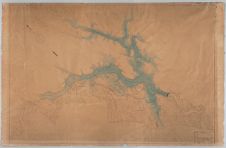
Topographic map of a section of the Yadkin River and surrounding area
- Title
- Topographic map of a section of the Yadkin River and surrounding area
- Description
- Scale [1" = 1000'] Topographic map of the Yadkin River near the cities of Whitney and Palmerville. Prospectus for building the Narrows Dam by the French company, the Southern Aluminium Company. The Narrows Dam and the Alcoa Smelting Plant are shown on the map. The introduction of water power created by the dam also brought about the development of the Town of Badin. The original map is currently held by the Badin Historic Museum in Badin, NC and it was digitized at the request of the museum. : Southern Aluminium Company
- Date
- January 1913
- Extent
- Local Identifier
- DAO67724
- Permalink
- https://digital.lib.ecu.edu/67724
- Preferred Citation
- Cite this item
- This item
-
 Topographic map of a section of the Yadkin River and surrounding area
- My Collections Login
- Printable Feedback Form
Related Search Results
Public access is provided to these resources to preserve the historical record. The content represents the opinions and actions of their creators and the culture in which they were produced. Therefore, some materials may contain language and imagery that is outdated, offensive and/or harmful. The content does not reflect the opinions, values, or beliefs of ECU Libraries.
Contact Digital Collections
If you know something about this item or would like to request additional information, click here.
Comment on This Item
Complete the fields below to post a public comment about the material featured on this page. The email address you submit will not be displayed and would only be used to contact you with additional comments or questions.