This is a worksheet for users to provide written feedback. Print this page, provide more information about the item, then return it to:
Digital Collections
c/o Joyner Library
1000 E. 5th Street
Greenville, NC 27858
c/o Joyner Library
1000 E. 5th Street
Greenville, NC 27858
Tell Us More
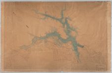
Title: Topographic map of a section of the Yadkin River and surrounding area
Identifier: DAO67724 (https://digital.lib.ecu.edu/67724)
Description: Scale [1" = 1000'] Topographic map of the Yadkin River near the cities of Whitney and Palmerville. Prospectus for building the Narrows Dam by the French company, the Southern Aluminium Company. The Narrows Dam and the Alcoa Smelting Plant are shown on the map. The introduction of water power created by the dam also brought about the development of the Town of Badin. The original map is currently held by the Badin Historic Museum in Badin, NC and it was digitized at the request of the museum. : Southern Aluminium Company
Please tell us more about this item:
