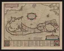
Mappa Aestivarum Isularum alias Barmudas dictarum
- Title
- Mappa Aestivarum Isularum alias Barmudas dictarum
- Description
- Color map of Bermuda including distances to Roanoke Island. (Amsterdam, Hodius, ca. 1633?) French text on verso. Caption title: L'isle de Barmudas avec ses voysines.
- Date
- 1633
- Original Format
- maps
- Extent
- 56cm x 43cm
- Local Identifier
- MC0036
- Publisher(s) of Original
-
Hondius, Hendrik, 1597-1651
- Subject(s)
- Bermuda Islands--Distances, etc.
- Roanoke Island (N.C.)--Distances, etc.
- Bermuda Islands--Maps--Early works to 1800
- Spatial
- Location of Original
- Special Collections Maps
- Rights
-
This item has been made available for use in research, teaching, and private study. Researchers are responsible for using these materials in accordance with Title 17 of the United States Code and any other applicable statutes. If you are the creator or copyright holder of this item and would like it removed, please contact us at als_digitalcollections@ecu.edu.
http://rightsstatements.org/vocab/InC-EDU/1.0/ - Permalink
- https://digital.lib.ecu.edu/1101
- Preferred Citation
- Cite this item
- This item
-
 Mappa Aestivarum Isularum alias Barmudas dictarum
- My Collections Login
- Printable Feedback Form
- Found in theme/project
-
 North Carolina Maps
-
 Special Collections Staff Picks
- Location of Original
- Mappa Aestivarum Insularum alias Barmudas dictarum : ad Ostia Mexicani aestuarij jacentium in latitudine graduum 32 minutorum 25. Ab Anglia Londino scilicet versus Libonotum 3300 Miliaribus Anglicanis, et a Roanoack (qui locus est in Virginia) versus Euronotum 500 Mill. accurate descripta. from the Special Collections Maps
Related Search Results

Public access is provided to these resources to preserve the historical record. The content represents the opinions and actions of their creators and the culture in which they were produced. Therefore, some materials may contain language and imagery that is outdated, offensive and/or harmful. The content does not reflect the opinions, values, or beliefs of ECU Libraries.
Contact Digital Collections
If you know something about this item or would like to request additional information, click here.
Comments
Comment on This Item
Complete the fields below to post a public comment about the material featured on this page. The email address you submit will not be displayed and would only be used to contact you with additional comments or questions.
I came across one of these maps. Where do you find the year on the map and how do I know if it is an original and the value? If it is the real thing I would like to sell it. Thanks