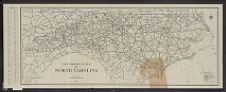
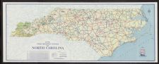
State highway system of North Carolina prepared by C.M. Sawyer.
- Title
- State highway system of North Carolina prepared by C.M. Sawyer.
- Description
- Raleigh : State Highway and Public Works Commission, 1933. 1 map : col. Scale [ca. 1:253,440]. Panel title: North Carolina highways, map of primary roads of the 58,000 mile system.; On verso: Table of distances between county seats, traffic laws, registration rates.; On verso: Places to go and things to see; Historic places in and about 100 county seats.State Highway and Public Works Commission
- Date
- 1933
- Extent
- 112cm x 43cm
- Local Identifier
- G3901.P2 1933 N67
- Creator(s)
- Contributor(s)
- Subject(s)
- Permalink
- https://digital.lib.ecu.edu/10793
- Preferred Citation
- Cite this item
- This item
-
 State highway system of North Carolina prepared by C.M. Sawyer.
- My Collections Login
- Printable Feedback Form
Related Search Results

Public access is provided to these resources to preserve the historical record. The content represents the opinions and actions of their creators and the culture in which they were produced. Therefore, some materials may contain language and imagery that is outdated, offensive and/or harmful. The content does not reflect the opinions, values, or beliefs of ECU Libraries.
Contact Digital Collections
If you know something about this item or would like to request additional information, click here.
Comment on This Item
Complete the fields below to post a public comment about the material featured on this page. The email address you submit will not be displayed and would only be used to contact you with additional comments or questions.