Soil scientist in a tobacco field
- Title
- Soil scientist in a tobacco field
- Description
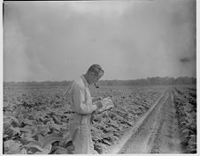
- Ed Karnowski, soil scientist with USDA Soil Conservation Service, preparing a soils map for a tobacco field. Date from negative sleeve.
- Date
- February 26, 1966
- Original Format
- negatives
- Extent
- 10cm x 12cm
- Local Identifier
- 0741-b39-fb-v39.b.93
- Contributor(s)
- Subject(s)
- Spatial
- Location of Original
- East Carolina Manuscript Collection
- Rights
-
Copyright held by East Carolina University. Permission to reuse this work is granted for all non-commercial purposes.
http://rightsstatements.org/vocab/InC-NC/1.0/ - Permalink
- https://digital.lib.ecu.edu/8822
- Preferred Citation
- Cite this item
- This item
-
 Soil scientist in a tobacco field
- My Collections Login
- Printable Feedback Form
- is part of
-
 Sleeve 93, Folder b, Box 39
- Found in theme/project
-
 Agriculture
-
 Daily Reflector Images
-
 Tobacco
- Location of Original
- Daily Reflector Negative Collection from the East Carolina Manuscript Collection
- View all digitized items from the Daily Reflector Negative Collection
Related Search Results
Public access is provided to these resources to preserve the historical record. The content represents the opinions and actions of their creators and the culture in which they were produced. Therefore, some materials may contain language and imagery that is outdated, offensive and/or harmful. The content does not reflect the opinions, values, or beliefs of ECU Libraries.
Contact Digital Collections
If you know something about this item or would like to request additional information, click here.
Comments
I used this picture in my book, "Promise of Better Days" as representative of man measuring tobacco. However, Joe Williams, of Duplin County, after reading my book describes the picture as following: The picture on page 73 is not measuring tobacco. The man is Ed Karnowshi with the Soil Conservation Service in Beaufort County and he is preparing a soils map of the area. The photograph he has is to the scale of an inch equals 1320 feet. ASCS used photos with a scale of an inch equals 660 feet. On these photos a square inch equaled 10 acres. Once a field of tobacco was plotted on the photo a rotometer was used to determine the acreage. Usually this was done by the office staff, but could be done in the field on the hood of a car.
Comment on This Item
Complete the fields below to post a public comment about the material featured on this page. The email address you submit will not be displayed and would only be used to contact you with additional comments or questions.
This gentleman is actually mapping the soil series for this field. USDA Soil Conservation Service produced a soils map for most if not all counties in North Carolina. His name is Ed Karnowski and he was a soil scientist.