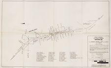
Eastern Craven County North Carolina Highway Map (Croatan to Havelock)
- Title
- Eastern Craven County North Carolina Highway Map (Croatan to Havelock)
- Description
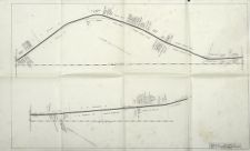
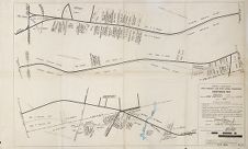
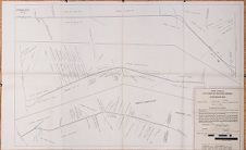
- Map of a section of U.S. Highway 70 showing ownership of land from Croatan to Havelock that later became part of Cherry Point Marine Corps Air Station at Havelock, North Carolina. Title supplied by cataloger. Courtesy of The State Archives of North Carolina.
- Date
- December 09, 1959
- Original Format
- maps
- Extent
- 42cm x 26cm
- Local Identifier
- 0753-fos1
- Subject(s)
- Spatial
- Location of Original
- East Carolina Manuscript Collection
- Rights
-
This item has been made available for use in research, teaching, and private study. Researchers are responsible for using these materials in accordance with Title 17 of the United States Code and any other applicable statutes. If you are the creator or copyright holder of this item and would like it removed, please contact us at als_digitalcollections@ecu.edu.
http://rightsstatements.org/vocab/InC-EDU/1.0/ - Permalink
- https://digital.lib.ecu.edu/57071
- Preferred Citation
- Cite this item
- This item
-
 Eastern Craven County North Carolina Highway Map (Croatan to Havelock)
- My Collections Login
- Printable Feedback Form
- Found in theme/project
-
 Military History
-
 Military History: Marines
-
 North Carolina Maps
- Location of Original
- Edward B. Ellis, Jr., Papers from the East Carolina Manuscript Collection
- View all digitized items from the Edward B. Ellis, Jr., Papers
Related Search Results
Public access is provided to these resources to preserve the historical record. The content represents the opinions and actions of their creators and the culture in which they were produced. Therefore, some materials may contain language and imagery that is outdated, offensive and/or harmful. The content does not reflect the opinions, values, or beliefs of ECU Libraries.
Contact Digital Collections
If you know something about this item or would like to request additional information, click here.
Comment on This Item
Complete the fields below to post a public comment about the material featured on this page. The email address you submit will not be displayed and would only be used to contact you with additional comments or questions.