Issued May 16, 1910.
U. S. DEPARTMENT OF AGRICULTURE,
BUREAU OF SOILS—MILTON WHITNEY, Chief.
IN COOPERATION WITH THE NORTH CAROLINA DEPARTMENT OF AGRICULTURE
W. A. GRAHAM, COMMISSIONER; B. W. KILGORE, STATE CHEMIST.SOIL SURVEY OF THE LAKE MATTAMUSKEETAREA, NORTH CAROLINA.BYW. EDWARD HEARN.[Advance Sheets—Field Operations of the Bureau of Soils, 1909.]United States Department of Agriculture 1862 Agriculture is the Foundation of Manufacture and Commerce 1889
Seal of the United States Department of AgricultureWASHINGTON:GOVERNMENT PRINTING OFFICE.1910.
[Public Resolution—No. 9.]
JOINT RESOLUTION Amending public resolution numbered eight, Fifty-sixth Congress, second session, approved February twenty-third, nineteen hundred and one “providing for the printing annually of the report on field operations of the Division of Soils, Department of Agriculture.”
Resolved by the Senate and House of Representatives of the United States of America in Congress assembled, That public resolution numbered eight, Fifty-sixth Congress, second session, approved February twenty-third, nineteen hundred and one, be amended by striking out all after the resolving clause and inserting in lien thereof the following:
That there shall be printed ten thousand five hundred copies of the report on field operations of the Division of Soils, Department of Agriculture, of which one thousand five hundred copies shall be for the use of the Senate, three thousand copies for the use of the House of Representatives, and six thousand copies for the use of the Department of Agriculture: Provided, That in addition to the number of copies above provided for there shall be printed, as soon as the manuscript can be prepared, with the necessary maps and illustrations to accompany it, a report on each area surveyed, in the form of advance sheets, bound in paper covers, of which five hundred copies shall be for the use of each Senator from the State, two thousand copies for the use of each Representative for the Congressional district or districts in which the survey is made, and one thousand copies for the use of the Department of Agriculture.
Approved, March 14, 1904.
[On July 1, 1901, the Division of Soils was reorganized as the Bureau of Soils.]
Issued May 16, 1910. U. S. DEPARTMENT OF AGRICULTURE, BUREAU OF SOILS—MILTON WHITNEY, Chief. IN COOPERATION WITH THE NORTH CAROLINA DEPARTMENT OF AGRICULTURE W. A. GRAHAM, COMMISSIONER; B. W. KILGORE, STATE CHEMIST. SOIL SURVEY OF THE LAKE MATTAMUSKEETAREA, NORTH CAROLINA.BYW. EDWARD HEARN. [Advance Sheets—Field Operations of the Bureau of Soils, 1909.]United States Department of Agriculture 1862 Agriculture is the Foundation of Manufacture and Commerce 1889Seal of the United States Department of AgricultureWASHINGTON:GOVERNMENT PRINTING OFFICE.1910.
LETTER OF TRANSMITTAL.
U. S. Department of Agriculture, Bureau of Soils, Washington, D. C., December 2, 1909.
Sir: I transmit for publication as advance sheets of Field Operations of the Bureau of Soils for 1909 manuscript report and map covering a soil survey of the Lake Mattamuskeet drainage district, situated in the northeastern part of North Carolina. This work was undertaken primarily at the request of the Office of Drainage Investigations of this Department, in furtherance of their investigations as to the feasibility of draining Lake Mattamuskeet and reclaiming the soils in the bottom of the lake for agricultural occupation. The selection of the area also bore the indorsement of the state officials, with whom the Bureau is cooperating in making a soil survey of the State, and also of Senator F. M. Simmons and Hon. John H. Small.
Very respectfully,
Milton Whitney, Chief of Bureau.
Hon. James Wilson, Secretary of Agriculture.
CONTENTS.| Page. | |
| Soil Survey of the Lake Mattamuskeet area, North Carolina. By W. Edward Hearn | 5 |
| Description of the area | 5 |
| Agriculture | 6 |
| Soils in the bed of Lake Mattamuskeet | 9 |
| Mattamuskeet silt loam | 9 |
| Mattamuskeet fine sandy loam | 10 |
| Mattamuskeet fine sand | 10 |
| Mattamuskeet very fine sandy loam | 10 |
| Mattamuskeet very fine sandy loam (shallow) | 11 |
| Soils surrounding Lake Mattamuskeet | 11 |
| Hyde very fine sandy loam | 11 |
| Hyde very fine sandy loam (flat) | 12 |
| Hyde silt loam | 13 |
| Hyde mucky loam | 14 |
| Peat | 16 |
Page.
FIGURE.
| FIG. 1. Sketch map showing location of the Lake Mattamuskeet area, North Carolina | 5 |
MAP.
Soil map, Lake Mattamuskeet sheet, .
SOIL SURVEY OF THE LAKE MATTAMUSKEET AREA, NORTH CAROLINA.
By W. EDWARD HEARN.
DESCRIPTION OF THE AREA.Lake Mattamuskeet is situated a little south and east of the center of Hyde County, in the extreme northeastern part of the State of North Carolina. It is about 14 miles long and 6 miles wide, and contains about 80 square miles, or 50,000 acres. The area surveyed includes the lake bed and a belt of country bordering the lake from 1 to 3½ miles wide. The surrounding upland included in the drainage district embraces about 70,000 acres of land, of which 30,000 acres are cleared and cultivated, the remaining portion being forest, savanna, or swamp. Surrounding the lake is a narrow ridge, varying in elevation from 3 to 9 feet above sea level, which is slightly higher than the adjoining lands. Back of this ridge the land is flat and level, with an elevation of from 1 to 5 feet above sea level. With the exception of this narrow ridge, which is gently rolling, the land has practically no natural surface drainage. It is so low and flat
Fig. 1.—Sketch map showing location of the Lake Mattamuskeet area, North Carolina.that rain water stands on it for a long time, and occasionally it is overflowed by waters from New Lake and Alligator River.
The drainage of the northern part is into Alligator River, while the southern and eastern sections drain into Pamlico Sound. There are several canals and ditches throughout the region, and many small ditches empty into the lake. On the southeast side Lake Landing Canal connects the lake with Wyesocking Bay and offers the only outlet for the drainage of Mattamuskeet Lake. There is a canal from Alligator River to Fairfield, which lies only a short distance from the lake. This is used for navigation, and a steamboat makes regular trips between Elizabeth City and Fairfield. This steamboat, together with other boats (principally sailboats and gasoline motor boats that run out from Engelhard, Swanquarter, and other points), furnish the only means of transportation for the area surveyed.
The Mattamuskeet Railroad is in course of construction from Fairfield around the lake by Engelhard, Middleton, and Swanquarter to Belhaven. Its completion and the operation of trains thereon depend in a large measure upon the draining of the lake or upon a few dry seasons in order that good crops may be produced.
Swanquarter, the county seat, Engelhard, and Middleton are small towns situated near the drainage district, while Fairfield is located within the district. At present Belhaven, 30 miles from Swanquarter, is the nearest railway station.
AGRICULTURE.The ridge land around the lake and the flat country around Fairfield on the north and Bell's Store on the south are thickly settled. A person can travel around the lake and never lose sight of a farm-house, except for a short distance on the west end, which section is forested. Lying back of this ridge and in the drainage district the country, with a few exceptions, is undeveloped. It is, however, thickly settled around Engelhard, Middleton, and Swanquarter.
The farmers, mainly of English descent, are intelligent and are especially hospitable and courteous to strangers. There are comparatively few negroes in the drainage district.
From Swanquarter around the bays and Pamlico Sound to Engelhard the fish and oyster industries are of considerable importance, and during recent wet years some farmers have given much of their time to these pursuits as a means of livelihood. On many of the poorly drained areas, especially on some of the Hyde mucky loam and the swampy phase of the Hyde very fine sandy loam, there is quite a large quantity of cypress and gum that will produce valuable lumber.
Much of the land in the drainage district has been in continuous cultivation for over one hundred years, and is still producing good
crops. This region has long been noted for its production of corn, and even before the civil war Hyde County was spoken of as the granary of eastern North Carolina, people going there from the central part of the State for their supply of corn.
Oats and wheat, as well as corn, were once the standard crops. About fifty years ago these soils produced good yields of wheat, but now many farmers claim that it can not be successfully grown. Rice was also produced to a considerable extent on the Hyde mucky loam, but its production has practically been abandoned on account of low prices, and because its culture assisted in the breeding or attracting of many insects which became so troublesome that no corn could be produced in the vicinity of a rice field.
Corn is now the principal crop. Oats are grown quite extensively; the Red Rust-proof variety seems to be best suited to the soil and climatic conditions. Some cotton is produced, and also several thousand bushels of cowpeas and a large quantity of Mammoth soja beans. Many of these peas and beans are shipped out of the country for seed. A few Irish potatoes are grown for early shipment. Sweet potatoes, particularly the Nancy Hall variety, do remarkably well on the drained soils. Pumpkins give good yields on black soil. Pecans, peaches, and figs do well on the ridge land. The Mattamuskeet apple, which originated here near the lake, is a fine-flavored winter apple and keeps well. Pears make a good growth, but soon blight. All kinds of garden vegetables, cabbage, celery, watermelons, etc., give excellent returns. Many hogs, a considerable number of cattle, and a few sheep are raised.
Until a few years ago practically no commercial fertilizer was used in the area surveyed. Some of the farmers now buy a complete fertilizer, analyzing phosphoric acid 8 per cent, nitrogen 3 per cent, and potash 3 per cent, and occasionally a higher grade is used, especially for potatoes and special crops. A great many buy potash and phosphoric acid for their black soils. Kainit, which is used by some, seems to prevent rust in cotton. Lime pays better than anything else; in fact, the black lands require it and do not produce well until limed. Some use whole shells, applying from 50 to 100 bushels per acre. These are good for slow or long-continued results. Burnt or ground shells, or slaked lime, are used for immediate results. It seems to be the general opinion that ground shells are preferable to rock lime. Shells can be obtained in abundance at a very reasonable cost.
The farmers in this section, except perhaps those on the sandy ridge, should never buy much nitrogen for their soils, for as a rule they need only lime, phosphoric acid, and potash. Nitrogen should be largely supplied for the sandy land by the growing of legumes.
Ridge land around the lake is valued at $50 to $100 an acre with improvements. Some of the black land is held at $30 to $60 an acre where cultivated, though it can be secured much cheaper where forested. The Peat, or savanna land, has no fixed market value and can be bought at very low prices.
For the past three years the seasons have been wet, and on account of insufficient drainage the crops have been drowned out on the flat lands. Some of the most fertile lands produce practically nothing, because of poor drainage. These lands when drained and reclaimed will be as productive as any in the State. On the wet areas during dry seasons large crops are produced with ease. Owing to their undoubted productivity, ease of cultivation, and fine situation, it is reasonable to believe that these soils when drained will attract a desirable class of settlers and make Hyde County one of the most prosperous agricultural counties in the State.
The greater part of the soils in the lake bed when drained and aerated will produce good crops. The kind of crops that can be most profitably grown will be determined by the transportation facilities, labor conditions, markets, and other factors. It is not likely that these soils will require much, if any, fertilizer during the first few years, but would probably be benefited by lime, as are all the soils in Hyde County. Being level, or practically so, free of rocks, stumps, or other obstruction, they will be easy to cultivate and machinery can be used most advantageously.
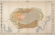
In the following pages the soils have been treated in groups—those at present covered by Lake Mattamuskeet and those lying around the lake. The following table shows the extent of these soils. In case of the types at present under water the areas are, of course, approximate, but near enough the actual conditions to give some idea of the area available for cropping if the lake should be drained. The accompanying map shows the distribution of the several types by means of colors.
| Soil. | Acres. | Per cent. | Soil. | Acres. | Per cent. |
| Mattamuskeet very fine sandy loam | 35,072 | 31.2 | Mattamuskeet fine sandy loam | 11,584 | 10.3 |
| Mattamuskeet very fine sandy loam (shallow) | Hyde silt loam | 8,000 | 7.1 | ||
| Hyde mucky loam | 24,128 | 21.4 | Mattamuskeet fine sand | 3,584 | 3.2 |
| Peat | 17,600 | 15.6 | Mattamuskeet silt loam | 704 | .6 |
| Hyde very fine sandy loam | 11,968 | 10.6 | Total | 112,640 | |
| Hyde very fine sandy loam (flat) |
The water level in Lake Mattamuskeet is now (March, 1909) about 1½ feet above sea level. The depth of the water in the lake ranges from 1 to 5 feet, it being shallowest on the southern side and deepest near the north side. The north side of the lake shore has been wearing away from wave action, while the land has been making on the south side.
From an examination of the character of the material in the lake bed it is reasonable to believe that the lake has been formed by natural processes, notwithstanding the Indian legend that it was formed by the burning out of extensive peat beds. The lake was formerly much deeper than at the present time, the bed in some parts now being 3½ feet below sea level, and it does not seem probable that a hole 5 or 6 feet below sea level was burned out so near the waters of Pamlico Sound. Water rises anywhere in the county to sea level, and when the peat near the lake was on fire a few years ago none burned below sea level. The lake is gradually filling up with the fine material brought in and deposited by the ditches and canals which empty into it. It is likely that fires have occurred around the edges of the lake in the peaty material during extremely dry times and in this way increased the size of the lake on the west end.
There are four distinct types of soil in the lake bed, and the approximate boundaries have been indicated on the accompanying map. At the head of Lake Landing Canal and near the mouth of some of the small canals and ditches that flow into the lake there occurs a shallow covering of smooth, slick, very fine sand and silt which is locally called “clabber.” On the north side and also partly on the west, peaty material formed from the decay of juniper logs washes ashore and is deposited. This material is spoken of as “coffee grounds.”
Five islands—Heron Bay, Big, Head Lake, House, and Topping—occur in the western end of the lake. Their surface is slightly elevated at normal water above the level of the lake, but are overflowed for the most part at times of high tide. The soil found on these islands has been called Mattamuskeet silt loam.
MATTAMUSKEET SILT LOAM.The Mattamuskeet silt loam consists of a black mellow silt loam or mucky loam varying in depth from 10 to 24 inches, with an average depth of 18 inches. The subsoil to a depth of 36 inches is generally a gray fine sand, with spots of brown fine sand and fine sandy loam.
The islands on which this type occurs are forested with cypress, elm, ash, and water willow, with some undergrowth of reeds and bamboo. During a dry season a few years ago, when the water in the lake was lower than at present, some of these islands were cultivated
to corn and produced good yields. The soil is well suited to the production of corn, oats, cotton, and special crops, such as celery, onions, cabbage, pumpkins, and soja beans.
On account of the high content of organic matter (24.36 per cent in the soil) the mechanical analysis of the type is omitted.
MATTAMUSKEET FINE SANDY LOAM.The soil of the Mattamuskeet fine sandy loam consists of a brown or black rather mucky fine sandy loam varying in depth from 10 to 20 inches. When this material has been washed ashore and freed of its mineral properties it is locally called “coffee grounds.” Most of this soil contains a noticeable amount of fine sand. There is a shallow sand shoal in this type on the north side. The subsoil is a gray fine sand and in spots a brown fine sand or gray loamy sand to a depth of 3 feet.
This type of soil occurs entirely in the western end of the lake, with the exception of one small spot in the northeast bend. It will produce cabbage, celery, potatoes, onions, and corn.
The following table gives the average results of mechanical analyses of samples of the soil and subsoil of this type:
| Number. | Description. | Fine gravel. | Coarse sand. | Medium sand. | Fine sand. | Very fine sand. | Silt. | Clay. |
| Per cent. | Per cent. | Per cent. | Per cent. | Per cent. | Per cent. | Per cent. | ||
| 20464, 20466 | Soil | 0.2 | 2.5 | 9.1 | 34.4 | 9.1 | 28.9 | 15.5 |
| 20465, 20467 | Subsoil | .0 | 1.9 | 11.9 | 37.6 | 28.2 | 15.0 | 5.3 |
The soil of the Mattamuskeet fine sand consists of a brown fine sand with spots of gray light fine sandy loam. There is a shallow covering of mucky material, especially where this type joins the Mattamuskeet fine sandy loam. In a few spots a sandy loam or blue sandy clay is encountered at lower depths.
This soil occurs in one rather small body in the center of the western portion of the lake, where the water is perhaps deepest. When drained it will be the early trucking soil of the lake bed. It will be especially adapted to potatoes, English peas, beans, watermelons, cantaloupes, and early corn, as well as to all kinds of garden vegetables.
MATTAMUSKEET VERY FINE SANDY LOAM.The Mattamuskeet very fine sandy loam consists of a grayish, silty, very fine sandy loam to a depth of at least 36 inches, being made up
chiefly of very fine sand and silt, with some clay and thin strata of mucky material. When wet much of the type has a brownish color, but upon drying it assumes a dark-gray or drab color. Occasionally a blue clay or fine sandy clay is encountered at 30 to 36 inches.
This type has the largest area of any in the lake bed. It covers the south side, occurs in the central portion, swings around to the southeast end, and occupies most of the northeastern portion of the lake bed.
When drained this soil will work up into a mellow tilth resembling that of a light silt loam. It will prove an excellent soil for general farming purposes and will produce good crops of corn, oats, peanuts, sweet potatoes, cotton, cowpeas, soja beans, cabbage, and other truck crops.
Mattamuskeet very fine sandy loam (shallow).—The surface soil of the Mattamuskeet very fine sandy loam (shallow) is a gray very fine sandy loam ranging in depth from 12 to 24 inches, and is similar in texture to the soil portion of the predominant phase described above. The subsoil is a blue clay containing a high percentage of silt. It is very plastic when wet but hard and stiff when dry. On exposure to the action of the atmosphere it turns dark gray or drab in color.
Only one body of this soil was found, and it occurs in the southeastern part of the lake. It will prove a very desirable soil, well suited to corn, oats, cotton, peanuts, peas, and soja beans.
The following table gives the average results of mechanical analyses of samples of the typical soil and single analyses of samples of the soil and subsoil of the shallow phase of this type:
| Number. | Description. | Fine gravel. | Coarse sand. | Medium sand. | Fine sand. | Very fine sand. | Silt. | Clay. |
| Typical: | Per cent. | Per cent. | Per cent. | Per cent. | Per cent. | Per cent. | Per cent. | |
| 20461, 20462, 20463 | Soil | 0.0 | 0.3 | 0.5 | 3.1 | 48.7 | 41.7 | 5.6 |
| hallow phase: | ||||||||
| 20459 | Soil | .0 | .3 | .0 | 1.4 | 42.2 | 48.9 | 7.0 |
| 20460 | Subsoil | .0 | 1.5 | 2.8 | 10.6 | 5.7 | 50.0 | 29.5 |
HYDE VERY FINE SANDY LOAM.
The soil of the Hyde very fine sandy loam in the largest and most typical areas consists of a gray very fine sandy loam from 6 to 18 inches deep. Where the soil contains considerable organic matter it is dark gray to black in color, and is more productive. The small strips on the south side of the lake have black to dark-gray surface
soils. This type is locally spoken of as “gritty land” on account of its sand content. It is a very mellow, easily tilled soil. The subsoil is a light-gray to whitish compact fine sand or sandy loam. The strips south of the lake have a dark-colored subsoil.
This soil occurs in one large area in the eastern part of the survey and in very narrow strips on the south side of the lake. A small body is found around Newlands and another near Last Chance.
The Hyde very fine sandy loam occupies the highest elevations in the survey, lying as a ridge from 3 to 9 feet above sea level, which is somewhat higher than the surrounding soil areas. Most of this soil has good natural surface drainage. In some of the level areas open ditches and canals carry off the rain water. This is the best drained land around the lake and the most certain to produce a crop during wet seasons. It is composed largely of very fine sand and silt, with some fine sand and clay, which materials have been reworked and deposited by wave and tide action. This ridge represents an old shore line.
Most of the type is cleared and cultivated. It was once forested with pine. It is well suited to cotton, corn, oats, potatoes, vegetables, and fruits. Corn yields from 20 to 30 bushels per acre and cotton from one-half bale to 1½ bales. Oats give small yields, while potatoes, vegetables, Scuppernong grapes, pecans, figs, and soja beans do well. In growing the field crops some of the farmers apply commercial fertilizers. A complete fertilizer, analyzing phosphoric acid 8 per cent, nitrogen 3 per cent, and potash 3 per cent, is commonly used. Other farmers buy only phosphoric acid and potash, especially in fields where they have previously grown cowpeas or soja beans.
Land of this type of soil, with smaller areas of adjoining soils, is held at $40 to $60 an acre.
Hyde very fine sandy loam (flat).—The soil of the flat phase of the Hyde very fine sandy loam is a black very fine sandy loam 3 to 10 inches deep. In the swampy areas, where heavily forested, spots of this soil have a mucky or black mucky fine sand surface, though some of it has a gray surface. A medium to fine sandy loam is encountered in a few places in the western part of the area. The subsoil is a white or light-gray very fine compact sand or sandy loam to a depth of 36 inches. In a few places a loam or black very fine sandy loam is found.
This phase of the type occurs as a strip varying in width from one-eighth mile to 1 mile, bordering the waters of the lake on the west, most of the south, and on the east. It lies between the upland and the water in the lake. It has a flat, level surface with a very gradual slope to the lake. Most of it is in a swampy condition and as the tide changes from one end of the lake to the other part of it is covered by water the greater part of the time.
The soil represents some of the coarser materials of the region which have been reworked and redeposited by wave action. The long continued swampy condition is responsible for the accumulation of considerable vegetable matter in some places. The principal growth is cypress, especially on the wet areas, some of which is valuable timber. On some of the drier areas field pine occurs, while on others gum is found.
When drained and cleared this soil would produce fair yields of cotton, peanuts, potatoes, corn, and all kinds of vegetables. Only a few spots are now cultivated and on these the crops produce fairly well when not drowned out.
The following table gives the results of mechanical analyses of samples of the typical soil and subsoil and of the soil and subsoil of the flat phase of this type:
| Number. | Description. | Fine gravel. | Coarse sand. | Medium sand. | Fine sand. | Very fine sand. | Silt. | Clay. |
| Typical soil: | Per cent. | Per cent. | Per cent. | Per cent. | Per cent. | Per cent. | Per cent. | |
| 20451 | Soil | 0.0 | 0.3 | 0.1 | 2.1 | 59.6 | 30.8 | 7.1 |
| 20452 | Subsoil | .0 | .1 | .0 | 1.9 | 77.9 | 18.1 | 2.0 |
| Flat phase: | ||||||||
| 20449 | Soil | .0 | .1 | .4 | 2.9 | 59.8 | 27.8 | .1 |
| 20450 | Subsoil | .0 | .2 | .0 | 1.5 | 88.3 | 8.2 | 1.8 |
The soil of the Hyde silt loam consists of a black to dark-gray mellow loam of fairly uniform texture to a depth of 36 inches. The soil is dark gray or drab in color when dry, but black and slightly plastic or sticky when wet. In places there is present a noticeable amount of very fine sand, especially on the north side of the lake. Near Lake Landing Canal there is more sand in the soil than is the case in typical areas. In the vicinity of Bell's Store the soil contains some fine sand and grades into a brown mucky material at 20 to 30 inches. When the uniformly mellow loam does not extend to a depth of 36 inches the subsoil is a brown or black mucky loam. A portion of the type is underlain at 3 feet by a brown fine sand.
This soil occurs mainly in two bodies. The largest body lies on the north side of the lake, attaining its greatest width between Fairfield and the lake. The other body lies on the south side of the lake, extending from Turnpike to Lake Landing. A body occurs near Bell's Store along the southern edge of the survey.
The Hyde silt loam forms the ridge on the north side of the lake and part of a ridge on the south side. It is usually slightly undulating except where it joins the mucky loam. The surface slopes toward
the lake and in the opposite direction toward the mucky loam. Part of it is almost flat. Its general elevation above sea level is from 2 to 5 feet. Some of it is fairly well drained by open ditches, but the back areas need drainage, as they are entirely too wet for good crops during wet seasons.
This type is composed of a small amount of very fine sand and considerable silt and clay, mixed with a large amount of finely divided and very well decomposed vegetable matter, thus making it an ideal loamy soil. Practically all of it is cultivated, the remaining few spots being forested to cypress and gum. The soil is especially suited to corn, oats, cotton, and soja beans. It will produce good pecans, figs and other fruits, potatoes, vegetables, and in fact all crops common to the county. Corn yields from 30 to 50 bushels per acre; oats, 30 to 75 bushels; cotton, from two-thirds bale to 1½ bales; and soja beans, about 25 bushels per acre. Potatoes, cowpeas, fruits, especially the Mattamuskeet apple, figs, celery, and vegetables do well. Lime pays well on this soil and its effects are quite lasting. A complete fertilizer is used by some of the growers; others buy only phosphoric acid and potash. Many apply barnyard manure and lime and nothing else. This is the most highly valued land around the lake. It sells at $75 to $100 an acre where there are good improvements. Practically none of this land is for sale.
The following table shows the results of mechanical analyses of samples of the soil and subsoil of this type:
| Number. | Description. | Fine gravel. | Coarse sand. | Medium sand. | Fine sand. | Very fine sand. | Silt. | Clay. |
| Per cent. | Per cent. | Per cent. | Per cent. | Per cent. | Per cent. | Per cent. | ||
| 20447 | Soil | 0.0 | 0.2 | 0.2 | 0.8 | 1.4 | 50.9 | 46.5 |
| 20448 | Subsoil | .0 | .0 | .1 | .3 | .1 | 40.6 | 59.0 |
| The following samples contained large quantities of organic matter: No. 20447, 17.58 per cent; No. 20448, 18.37 per cent. |
The Hyde mucky loam is a gradation phase or intermediate type between the Hyde silt loam and the Peat. The soil consists of a black mucky loam ranging in depth from 4 to 18 inches. The shallowest surface soil is found adjoining the Peat areas, in the Florida section, north of Fairfield, while the deepest phase is encountered south of the lake on Makeley's farm and in that vicinity, where the soil is from 10 to 18 inches deep. Part of the type has in time past been burned over and occasionally a few charcoal particles are
present, giving it a granular feel, or a thin layer of ashes may lie immediately below the soil. The subsoil to a depth of 36 inches is a soft, mellow brown mucky to peaty material, practically free from any mineral matter. A brown fine sand underlies this subsoil at depths of from 3 to 5 feet. It is only in a few local spots that the fine sand is found nearer the surface than 3 feet.
This soil occupies the largest area of any type around the lake. It occurs mainly in two large bodies, one on the north side of the lake and the other on the south side. It also occurs as a very narrow strip between the Hyde silt loam and the Peat. It is typically developed in the Florida section near Fairfield and east thereof to the back of Mr. H. C. Carter's place on the north side of the lake, while on the south side a large area lies immediately south of Lake Comfort and runs eastward to Lake Landing Canal.
The Hyde mucky loam occupies level and basinlike areas which are somewhat lower than the surrounding soils. The elevation of this type ranges from 3 inches in the Florida section to 4 feet in other localities. Some of it lies lower than water level in Lake Mattamuskeet. It has no natural drainage. Open ditches and canals serve to drain part of it during dry years, while in wet years it is saturated.
The soil owes its origin to the decay and decomposition of vegetable matter, such as trees, limbs, leaves, reeds, and water-loving grasses, and with this material is a small amount of mineral matter. Juniper logs are encountered in some places in this soil at 2 or 3 feet below the surface, indicating that a portion of the type was once a juniper swamp.
A considerable portion of the type is cleared and cultivated, while the remaining area represents forests of cypress and gum, and land abandoned on account of inadequate drainage. The forests contain valuable timber for the manufacture of shingles and staves. The soil is well adapted to corn, rice, oats, celery, onions, and cabbage. Corn yields 30 to 45 bushels; oats from 30 to 40 bushels; rice 35 to 40 bushels, though as high as 75 bushels have been grown; and cotton, on the drained land, from two-thirds bale to 1½ bales per acre. Clay cowpeas, soja beans, pumpkins, and other vegetables do well. When better drained this will be one of the most productive soils in Hyde County. It is very rich in nitrogen and needs only potash and phosphoric acid. It is very acid in character and requires heavy applications of lime in order to obtain the best results. The beneficial effect of lime can be seen to the exact row in the field where it is used.
This land is easy to cultivate, and readily crumbles when plowed. The cultivated areas are held at from $40 to $60 an acre; the forested areas can be bought for less.
The following table gives the average results of mechanical analyses of samples of the soil and subsoil of the Hyde mucky loam:
| Number. | Description. | Fine gravel. | Coarse sand. | Medium sand. | Fine sand. | Very fine sand. | Silt. | Clay. |
| Per cent. | Per cent. | Per cent. | Per cent. | Per cent. | Per cent. | Per cent. | ||
| 20453, 20455 | Soil | 0.1 | 1.3 | 1.1 | 2.9 | 3.2 | 47.7 | 43.6 |
| 20454, 20456 | Subsoil | .1 | .1 | .2 | 1.8 | 9.4 | 54.4 | 34.0 |
| The following samples contained large quantities of organic matter: No. 20453, 50.46 per cent; No. 20454, 41.92 per cent; No. 20455, 23.44 per cent; No. 20456, 14.80 per cent. |
In the Peat areas to a depth of 1 or 2 inches there commonly occurs a black mucky material occasionally containing a few particles of charcoal. This grades into a brown peat which extends to a depth of from 3 to 8 feet, where it is underlain by a grayish fine sand. In the timbered areas which have never been burned the brown peaty material begins at the surface. The Peat is locally called “savanna land.” A considerable part of it was burned over five or six years ago, and some of it was burned over more than one hundred years ago. The soil is soft, brown, and practically free from fibrous material, except for the juniper logs, stumps, limbs, etc., occasionally found beneath the surface. It seems that the Peat area was once a juniper forest.
The Peat area begins on the west side of the Donald farm and swings around the west end of the lake to near Newlands, varying in width from three-fourths of a mile to 2 miles. It begins again along the Fairfield Canal and forms the northern boundary of the district, reaching to within a short distance of Engelhard. The areas mapped represent only a small part of the Peat that occurs in Hyde County, larger areas lying to the west and north. The surface is practically level, except where fires have burned out a few holes and left a few knolls 1 to 2 feet above the surrounding lands. The general elevation varies from 1 to 6 feet above sea level. The soil has no natural surface drainage, and it is wet the year around, a part of it being covered with water, except during dry seasons. The Peat burns readily when dry and the fires are very difficult to extinguish.
This Peat has been formed from the decay of juniper and cypress trees, limbs, leaves, reeds, sphagnum mosses, and other water-loving plants that have deposited their remains in this once swampy area. Some of this Peat is practically a treeless prairie, the growth consisting of a few pond pines and galberry and bay bushes. Areas of such scant tree growth are locally classed as “open savanna.” In
some places there are considerable pond pine or shrub pine, cypress, gum, and galberry bushes. Most of the merchantable timber has been cut.
None of this land is under cultivation at present. When drained and brought under cultivation it will likely produce good crops of celery, cabbage, onions, and possibly corn, if lime, potash, and phosphoric acid are liberally applied. There has been no definite value placed upon this land, but according to report it can be bought at $2 an acre up.
A sample of this soil was taken about 2 miles northeast of Swanquarter on the Swanquarter Lake road and used in making wire-basket tests in the growing of wheat, corn, and cowpeas under different fertilizer treatments. The soil material was analyzed and shown to be composed of 88.80 per cent organic matter, 0.33 per cent lime, 0.02 per cent of phosphoric acid, and 0.1 per cent of potash. The fertilizer treatments were the same for each crop, and consisted of nitrate of soda, sulphate of potash, and calcium acid phosphate alone and in combinations of 2 and 3 with and without lime and also of lime alone and stable manure alone. In the case of wheat a marked increase in growth resulted in the use of nitrate of soda alone, calcium acid phosphate alone, nitrate of soda and sulphate of potash and calcium acid phosphate, and from the use of the three salts in combination with and without lime, the increase in the case of the last named being three and a half times the growth in the control basket containing the untreated soil. Lime alone gave an increase in the case of wheat two and a half times the growth of the control. Sulphate of potash alone gave the least increase, and manure alone came next with a gain of 61 per cent over the control. In these tests the results with wheat showed much greater increases than with either corn or cowpeas. Nitrate of soda alone gave the best results with corn, but the increase over the control was only 46 per cent. With cowpeas the best results were secured with a complete fertilizer and lime in combination, followed by lime alone and then by nitrate of soda. It is somewhat remarkable that in a soil composed almost entirely of organic matter nitrate of soda should give such marked increases in crop growth.