U. S. DEPARTMENT OF AGRICULTURE,BUREAU OF SOILS—MILTON WHITNEY, Chief.SOIL SURVEY OF PERQUIMANS AND PASQUOTANK COUNTIES,NORTH CAROLINA.
BYJ. E. LAPHAM AND W. S. LYMAN.[Advance Sheets—Field Operations of the Bureau of Soils, 1905.]United States Department of Agriculture 1862 Agriculture is the Foundation of Manufacture and Commerce 1889
Seal of the United States Department of AgricultureWASHINGTON:GOVERNMENT PRINTING OFFICE.1905.
U. S. DEPARTMENT OF AGRICULTURE,BUREAU OF SOILS—MILTON WHITNEY, Chief.SOIL SURVEY OF PERQUIMANS AND PASQUOTANK COUNTIES,NORTH CAROLINA.BYJ. E. LAPHAM AND W. S. LYMAN. [Advance Sheets—Field Operations of the Bureau of Soils, 1905.]United States Department of Agriculture 1862 Agriculture is the Foundation of Manufacture and Commerce 1889
Seal of the United States Department of AgricultureWASHINGTON:GOVERNMENT PRINTING OFFICE.1905.
[Public Resolution—No. 9.]
JOINT RESOLUTION Amending public resolution numbered eight, Fifty-sixth Congress, second session, approved February twenty-third, nineteen hundred and one, “providing for the printing annually of the report on field operations of the Division of Soils, Department of Agriculture.”
Resolved by the Senate and House of Representatives of the United States of America in Congress assembled, That public resolution numbered eight, Fifty-sixth Congress, second session, approved February twenty-third, nineteen hundred and one, be amended by striking out all after the resolving clause and inserting in lieu thereof the following:
That there shall be printed ten thousand five hundred copies of the report on field operations of the Division of Soils, Department of Agriculture, of which one thousand five hundred copies shall be for the use of the Senate, three thousand copies for the use of the House of Representatives, and six thousand copies for the use of the Department of Agriculture: Provided, That in addition to the number of copies above provided for there shall be printed, as soon as the manuscript can be prepared, with the necessary maps and illustrations to accompany it, a report on each area surveyed, in the form of advance sheets, bound in paper covers, of which five hundred copies shall be for the use of each Senator from the State, two thousand copies for the use of each Representative for the Congressional district or districts in which the survey is made, and one thousand copies for the use of the Department of Agriculture.
Approved, March 14, 1904.
[On July 1, 1901, the Division of Soils was reorganized as the Bureau of Soils.]
CONTENTS.| Page. | |
| Soil Survey of Perquimans and Pasquotank Counties, North Carolina. By J. E. Lapham and W. S. Lyman | 5 |
| Location and boundaries of the area | 5 |
| History of settlement and agricultural development | 6 |
| Climate | 7 |
| Physiography and geology | 7 |
| Soils | 9 |
| Norfolk fine sand | 9 |
| Norfolk fine sandy loam | 11 |
| Portsmouth fine sandy loam | 12 |
| Portsmouth silt loam | 14 |
| Portsmouth loam | 15 |
| Norfolk silt loam | 16 |
| Swamp | 17 |
| Agricultural methods | 18 |
| Agricultural conditions | 19 |
TEXT FIGURE.
| Page. | |
| Fig. 1. Sketch map showing location of the Perquimans and Pasquotank counties area, North Carolina | 5 |
MAP.
Soil map, Perquimans-Pasquotank counties sheet, North Carolina.
SOIL SURVEY OF PERQUIMANS AND PASQUOTANK COUNTIES, NORTH CAROLINA.
By J. E. LAPHAM and W. S. LYMAN.
LOCATION AND BOUNDARIES OF THE AREA.Perquimans and Pasquotank counties comprise an area of about 460 square miles, situated in the northeastern part of North Carolina, on the northern side of Albemarle Sound. The center of the area is approximately in west longitude 75° 15′ and north latitude 36° 15′. The southeastern end of Pasquotank County is about 20 miles from the Atlantic Ocean, while the northwestern end reaches to within a few miles of Virginia. From the southeast to the northwest Pasquotank County measures about 33 miles, and Perquimans County 26
Fig. 1.—Sketch map, showing location of the Perquimans and Pasquotank counties area, North Carolina.miles, while from southwest to northeast the distance across the two counties in 25 miles. Pasquotank County is separated from Camden County on the northeast by Pasquotank River, and upon the northwest it is bounded by Gates County. Perquimans County is bounded upon the west and northwest by Chowan County, and upon the north by Gates County. With the exception of about 2 miles of its western end, the Perquimans-Gates line runs through the Dismal
Swamp, and is unmarked. The county officials were unable to supply exact information respecting its location, and its approximate position is therefore drawn upon the map as nearly as may be from hearsay and from measurement of a small-scale State map. The same indefiniteness exists respecting the location of the northwesterly 2 or 3 miles of the Pasquotank-Camden line, where the Pasquotank River commences its existence in the Dismal Swamp. The Pasquotank-Gates and part of the Pasquotank-Perquimans lines were mapped according to data furnished by an old sketch found in Pasquotank County courthouse, the more explicit memoranda of the early survey having been destroyed.
HISTORY OF SETTLEMENT AND AGRICULTURAL DEVELOPMENT.The history of the early settlement of this area began in 1662, when George Durant purchased from the king of the Yeopim Indians the tract of land now known as Durants Neck, lying upon Albemarle Sound, between Little and Perquimans Rivers, in Perquimans County. The titles to this tract of land is the oldest on record in North Carolina, and Durants Neck is the site of the first permanent settlement in the State. Durant was soon followed by other settlers, among them a number of Quakers, who moved to North Carolina from the New England States in search of a place where they might live in peaceful enjoyment of religious liberty. Some of them also settled in Pasquotank County, and it was there, in 1703, that the oldest meetinghouse in the State of which they possess any record was built.
Perquimans and Pasquotank, together with other of the eastern counties, were, in the early history of the State, included in what was known as Albemarle County. This section of the State was then difficult of access from the north on account of the many swamps and morasses and the lack of roads between it and Virginia. Commerce with the North was consequently greatly restricted until after the opening of the Dismal Swamp Canal in 1836. Prior to that time, and especially after the close of the Revolutionary War, the settlers carried on a brisk and profitable trade with the West Indies. This consisted principally of the exchange of lumber and such forest products as staves and shingles riven from the juniper and cypress, then so abundant in the great swamps, together with corn and other farm produce, for sugar, molasses, rum, and other products and fruits of the Tropics. Along Albemarle Sound fishing was then, as now, an important industry. Corn is and always has been the principal farm crop of the area, though prior to the competition of the West wheat was also grown to quite a large extent. Cotton was grown at an early day, the seeds being removed by hand and the fiber manufactured into clothing on hand looms, but it did not reach a position of importance among the products of the area until after the close of
the Civil War. In 1900, according to the Twelfth Census, about 5,400 bales were reported in the area.
After the construction of the Dismal Swamp Canal, up to 1881, communication with the outside world was by boat; but in the latter year the Norfolk and Southern Railroad penetrated the Albemarle section, bringing to the inhabitants readily appreciated facilities for the speedier transportation of freight, as well as an improved passenger and mail service. In the last decade the agricultural and industrial progress has been more rapid than before, and farm and real estate values are gradually advancing.
CLIMATE.The climate of the area is characterized by long summers and comparatively short, mild winters. The average annual temperature, as shown by the appended table, prepared by the Weather Bureau, is 60° F., which is 1° warmer than at Norfolk. The distribution of the temperature and rainfall over the different months is favorable to a long growing season, and few summer days are so disagreeably hot as to interfere seriously with work out of doors. The autumns are generally warm and dry, and are sufficiently long to allow the harvesting of the cotton and corn crops before the rains of the winter set in. The most severely cold weather occurs during January and February. The ground, however, seldom remains frozen for more than a few days at a time, and the snowfall is light, being usually not more than an inch at a time, and remaining upon the ground but two or three days at most. Plowing is commenced in February, and potatoes are frequently planted by the latter part of that month.
| Month. | Edenton. | Kitty Hawk. | Month. | Edenton. | Kitty Hawk. | ||||
| Temperature. | Precipitation. | Temperature. | Precipitation. | Temperature. | Precipitation. | Temperature. | Precipitation. | ||
| °F. | In. | °F. | In. | °F. | In. | °F. | In. | ||
| January | 41.9 | 3.48 | 42.4 | 5.20 | August | 79.6 | 5.14 | 77.6 | 6.84 |
| February | 41.8 | 4.72 | 46.0 | 3.75 | September | 72.4 | 2.74 | 73.4 | 4.65 |
| March | 51.3 | 3.96 | 47.4 | 5.16 | October | 62.1 | 4.44 | 63.6 | 3.70 |
| April | 58.0 | 2.99 | 55.8 | 4.45 | November | 52.4 | 3.21 | 53.5 | 4.04 |
| May | 68.5 | 5.44 | 66.0 | 3.74 | December | 42.6 | 3.03 | 46.2 | 4.16 |
| June | 75.2 | 3.56 | 74.2 | 4.60 | |||||
| July | 80.2 | 5.08 | 78.0 | 5.80 | Year | 60.5 | 47.79 | 60.3 | 56.09 |
The area included in the survey consists of an almost level plain, rising gently to the northwest from Albemarle Sound. Its minimum elevation above the sound in Pasquotank County is about 4 to 6 feet,
and in Perquimans County is somewhat greater. The maximum height of about 50 feet is reached west of Belvidere, on a narrow terrace extending parallel with and along the Perquimans-Chowan county line. This terrace, which is evidently an old shore line, reaches over into Perquimans County for an average distance of about 1 mile, and extends northward about 8 miles, where it disappears into Chowan and Gates Counties. Just off this terrace the general level is from 20 to 25 feet, giving a fall to the sound of about a foot to the mile. North of Perquimans and northwest of Pasquotank County the surface slopes to the Dismal Swamp, about 50 square miles of the southern prolongation of which is included in the area. This descent is made in a few feet, the swamp being but little lower than the surface of the surrounding country.
Perquimans and Pasquotank Rivers have their rise in the southern edge of this swamp, their upper courses being characterized by narrow and tortuous channels, fringed for the most part by gum and cypress swamps of varying width. At about three-fifths of the distance from their source to their mouth they suddenly widen into estuarylike arms of Albemarle Sound, and from Elizabeth City to Wades Point, a distance of about 14 miles, the Pasquotank River averages 2 miles in width, while Perquimans River averages about 1¼ miles in width. Little River also forms an important arm of the sound, the estuarine extension of which is about 8 miles long and 1 mile wide. The widened lower courses of these rivers appear to have been, during comparatively recent geological times, tidal rivers or estuaries, like the Elizabeth River, at Norfolk, at the present time. Since the lunar tides were cut off from Albermarle Sound, by the recession of the ocean and the building of island barriers along the shore, no periodical tides exist, but only such fluctuations in the height of the water as are caused by the stronger and more constant winds, these being locally called tides. Though there is consequently little erosion from tidal scouring going on in these arms, their channels are being quite rapidly widened from year to year by the wave action upon the crumbling banks.
The stream system of the area is completed by tributary streamlike swamps, which serve as natural drainage ways, irregularly distributed over the two counties.
Geological classification places the area in what is known as the Columbia formation. This formation is built up from mineral materials brought down by streams from the Piedmont Plateau, lying to the westward, and deposited as sediments of various grades of fineness, at a time in geological history when the coast of North Carolina was submerged under the edge of the Atlantic Ocean. The distribution of these sediments was controlled by ever-varying current and wave action, modified to some extent by stream erosion after
the emergence of the land. The texture of some of the soil types has also been modified in a measure by the incorporation of considerable amounts of organic matter, resulting from the decay of quantities of vegetation accumulated while the country was yet in a semiswamp condition.
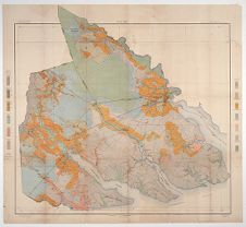
SOILS.Excluding Swamp, six distinct types of soil have been recognized and mapped in the area. The actual and relative extent of each type is shown in the following table:
| Soil. | Acres. | Per cent. | Soil. | Acres. | Per cent. |
| Portsmouth silt loam | 110,016 | 37.3 | Norfolk silt loam | 9,344 | 3.2 |
| Swamp | 57,536 | 19.6 | Norfolk fine sand | 6,976 | 1.9 |
| Norfolk fine sandy loam | 43,968 | 15.1 | |||
| Portsmouth loam | 41,536 | 14.3 | Total | 294,848 | |
| Portsmouth fine sandy loam | 25,472 | 8.6 |
The Norfolk fine sand consists of a loose, incoherent sandy soil, in most cases extending to a depth of 3 feet or more. In some instances, however, there is a slight tendency to coherency at 30 inches, indicating the presence of some silt and clay. The texture throughout the greater part of the section is that of a medium to fine sand, few coarse grains being present. The surface 7 or 8 inches ranges from a yellowish brown to a gray and possesses a variable amount of organic matter. Below this depth the color changes abruptly to a uniform yellow, which in most instances continues to 3 feet or more, though loose white sand was in some localities, especially on the terrace along the Chowan County line, encountered at 30 inches.
The Norfolk fine sand occurs in relatively small, irregular, isolated patches along the upper courses of Perquimans and Pasquotank Rivers and the smaller streams in both counties. Its best representation, however, occurs along the northern half of the Perquimans-Chowan county boundary line, where it is found extending in a slightly interrupted strip about 8 miles long and 1 mile wide. Small bodies of Norfolk fine sand occur infrequently, scattered about as islands or ridges in some of the larger river swamps, as well as in the “desert.” They are too difficult of access to make them of much agricultural value, and they were usually too small and irregular to warrant their designation on the map.
Along the Chowan County line the soil occupies a nearly flat-topped terrace, attaining a maximum elevation of about 50 feet, or
from 20 to 25 feet higher than the general level of Perquimans County, half a mile eastward, off the terrace. The surface of the Norfolk fine sand here is generally slightly undulating, as is also the case in other parts of the area, where it occurs along the margins of swamps and streams. In the latter positions it lies from 3 to 10 feet above the level of the drainage.
Good natural drainage is secured over the greater part of the terrace phase of the type by reason of its somewhat rolling surface and the loose, porous character of the subsoil, which allows the ready percolation of excess rain waters. In a few small local spots of depression water stands for a short time following rains, and in some of these places organic matter has accumulated in sufficient quantity to color the soil almost black. Along the margins of the rivers and swamps the porosity of the Norfolk fine sand, together with its natural fall and nearness to drainage channels, secures for it adequate drainage in most cases without resort to artificial means.
The Norfolk fine sand is derived from the coarser sediments brought down from the Piedmont Plateau and deposited during submergence under the Atlantic Ocean or its estuaries. These sediments have since been rearranged and redistributed in the course of subsequent erosion. The terrace phase of the Norfolk fine sand, however, probably marks an old beach line, and the mineral particles have undergone comparatively little change in position or arrangement since the recession of the ocean.
The Norfolk fine sand is the highest type of trucking soil in the area, and is the most suitable soil for the production of the earliest vegetables and small fruits. It is especially adapted to early peas, asparagus, and sweet and Irish potatoes. It is also a good peanut soil. It is not very retentive of fertilizers, and is too droughty a soil for corn and cotton. The physical condition of the soil would be greatly improved by the liberal application of barnyard manure.
With the exception of a few peas and Irish potatoes little trucking is done in the area, and the type is devoted to various ordinary farm crops. Cotton and corn are grown, the former yielding about half a bale to the acre under fertilization, and the latter from 5 to 15 bushels. Sweet potatoes for home consumption are grown upon this type, and to some extent for shipment, and give fair yields. In Perquimans County a portion of the area of the type is devoted to the production of peanuts. Little fruit is grown, except on the terrace phase on the western edge of Perquimans County, where the Scuppernong and Mish grapes are cultivated both for home consumption and market.
The following table shows the results of mechanical analyses of typical samples of the Norfolk fine sand. The figures represent the averages for two samples each of soil and subsoil.
| Number. | Description. | Fine gravel. | Coarse sand. | Medium sand. | Fine sand. | Very fine sand. | Silt. | Clay. |
| Per cent. | Per cent. | Per cent. | Per cent. | Per cent. | Per cent. | Per cent. | ||
| 12451, 12449 | Soil | 0.0 | 3.6 | 12.7 | 66.1 | 4.4 | 7.0 | 6.1 |
| 12452, 12450 | Subsoil | .1 | 3.2 | 10.8 | 69.7 | 4.0 | 7.5 | 4.5 |
The soil of this type is a yellowish-gray fine sandy loam extending to a depth of about 10 inches. The first 6 inches of this section is not infrequently a quite incoherent fine sand, becoming loamy before the limiting depth of the soil is reached. The subsoil to an observed depth of 36 inches is a mottled yellow and gray fine sandy loam, becoming quite heavy in the intermediate depths and containing considerable silt and clay. At from 30 to 36 inches a tendency is frequently shown toward a sandier, coarser texture. There are a few areas of local extent where the surface soil is a darker gray than usual, and where the subsoil shows rather less of the yellow iron coloring. This condition is usually found in localities contiguous to the Portsmouth fine sandy loam or Portsmouth silt loam.
The greater proportion of this type lies in the central and upper parts of the two counties, where it usually occurs in positions adjacent to streams and drainage sloughs and swamps.
Slight undulations are usually exhibited in the topography of the Norfolk fine sandy loam, and the natural drainage is somewhat better than that of the Portsmouth silt loam. Except immediately along the streams, however, ditching is necessary to fit the land for cultivation.
The Norfolk fine sandy loam is of sedimentary origin, and is the result of the same processes which operated in forming the other soils of the area. To the assorting power of water is due, in some measure at least, the absence of the type from the lower river necks and the deposition of these coarser sediments higher up the stream.
Except that the texture of this type is rather light for corn, it is one of the best soils in the area for general farm purposes. It is a very good soil for cotton, possessing a subsoil retentive of moisture and fertilizers. Cotton comes to earlier maturity than upon the heavier gray soils and gives fair yields, about three-fourths bale to the acre being a good average. Corn produces about 18 bushels per acre. It is not so well suited to peanuts as is the Norfolk fine sand.
There is a phase of the Norfolk fine sandy loam, occurring mainly along the narrow drainage swamps and also adjacent to the swamps that border the narrow parts of the Perquimans and Pasquotank
Rivers in the upper parts of the two counties and in the vicinity of Hertford and Elizabeth City, which differs somewhat from the general description above given, more especially as regards adaptation to crops. The soil from 10 to 18 inches is a brown, slightly loamy sand of fine texture, underlain to a depth of 36 inches by a heavier yellowish to reddish sandy loam, becoming quite compact in the lower depths. In some localities, however, especially near areas of the Norfolk fine sand, the subsoil is less compact, possessing a loose, loamy consistency throughout.
This phase of the Norfolk fine sandy loam is perhaps the best all-round trucking soil of the area, and is well adapted to the production of strawberries, peas, early radishes, Irish and sweet potatoes, and other vegetables and fruits requiring a light, easily drained soil. It should also prove admirably adapted to bright tobacco. In Perquimans County, besides corn and cotton, peanuts are also grown to a considerable extent upon this phase of the type.
The following table shows the results of mechanical analyses of typical samples of the soil and subsoil of the Norfolk fine sandy loam. The figures represent the averages for five samples each of the soil and the subsoil.
| Number. | Description. | Fine gravel. | Coarse sand. | Medium sand. | Fine sand. | Very fine sand. | Silt. | Clay. |
| Per cent. | Per cent. | Per cent. | Per cent. | Per cent. | Per cent. | Per cent. | ||
| 12457, 12455, 12176, 11664, 12459. | Soil | 0.1 | 2.3 | 4.2 | 44.9 | 19.6 | 21.3 | 7.2 |
| 12456, 12177, 12458, 11665, 12460. | Subsoil | .1 | 1.8 | 3.9 | 42.3 | 15.5 | 21.7 | 14.5 |
The Portsmouth fine sandy loam has an average depth of about 10 inches, and consists of a dark-gray or brownish-gray sandy loam which ranges from medium to fine in texture and contains considerable silt. It is for the most part mellow and loose enough in structure not to clod to any great extent. The subsoil is heavier and much more compact, and contains a larger percentage of silt. The color is an intermixed light and dark gray, mottled with yellow and brown iron stains. At 30 inches or less, looser, sandier material of a uniform light-gray color is commonly encountered.
In some parts of the area mapped, in the vicinity of Yeopim and along the Bear Swamp Road, the soil is looser and deeper than usual and the subsoil is better oxidized, as indicated by a more yellow color. It is recognized that in these localities some areas of Norfolk fine sandy loam exist, but they are too small and irregular in outline to permit of mapping on the scale used.
The Portsmouth fine sandy loam is principally confined to the upper two-thirds of the area, though it is represented in nearly all parts of both counties, except in the river or sound necks. The type is quite frequently found abutting upon the Portsmouth loam near the margins of the pocosons. It generally occupies flat or slightly depressed areas. There is seldom any topographical relief, and the drainage is always inadequate except as effected by artificial means. In many instances areas of Portsmouth fine sandy loam are situated at some distance from natural drainage channels, and long ditches have to be dug.
The Portsmouth fine sandy loam is derived from the sediments deposited in the most recent geologic age and in the same manner as the other soils of the area. Its darker color is due to the larger amount of organic matter accumulated under poorer natural drainage conditions.
The type is adapted to the production of general farm crops, and especially to those requiring a medium heavy soil that is easy of cultivation and yet able to maintain sufficient moisture for the needs of most crops during periods of comparative drought. It is a better soil for corn than for cotton, the rather too generous supply of moisture prolonging the growth and maturity of the cotton boll too far into the season. It is well adapted to late cabbage, radishes, turnips, and other vegetables of this class, which require a rather heavy, retentive soil.
Corn is the principal crop grown, and with moderate fertilization will produce about 20 bushels to the acre. Although probably 25 per cent of the cultivated area of this type is devoted to cotton, the soil is too heavy and late and the yield is unprofitably low, except upon the highest and best drained portions of the type.
Besides pine, which occurs on all the other arable types, the natural forest growth is characterized by the presence of sweet gum and black gum. Along ditches an abundant growth of cane is characteristic of this type, and is also present, though to a less extent, in some of the lowest areas of woodland.
The following table gives the results of mechanical analyses of typical samples of the Portsmouth fine sandy loam, the figures representing the average of two samples each of the soil and the subsoil.
| Number. | Description. | Fine gravel. | Coarse sand. | Medium sand. | Fine sand. | Very fine sand. | Silt. | Clay. |
| Per cent. | Per cent. | Per cent. | Per cent. | Per cent. | Per cent. | Per cent. | ||
| 12471, 12467 | Soil | 0 | 0.5 | 2.8 | 59.8 | 8.6 | 14.8 | 13.1 |
| 12468, 12472 | Subsoil | 0 | .4 | 2.5 | 55.2 | 6.8 | 15.7 | 19.3 |
PORTSMOUTH SILT LOAM.
The Portsmouth silt loam averages about 9 inches in depth, and consists for the most part of a friable silt loam of a very uniform texture. In some localities, however, the soil becomes somewhat coarser, and in a few instances even contains about 20 per cent of very fine sand. The predominant color is a medium gray, mottled sometimes with lighter and darker shades. The subsoil, extending from 9 to 36 inches, is a heavy gray silt loam, mottled with drab and with buff and brown iron stains. The subsoil, especially in its lower depths and nearer the surface in the heavier phases of the type, sometimes exhibits a greasy, waxy consistency, showing the presence of considerable clay.
The Portsmouth silt loam is by far the most uniform of any of the soil types in this survey in all its characteristics, the color, texture, and drainage exhibiting a striking sameness in the different areas where it is encountered. In one or two localities, however, as over a limited area about 5 miles northwest of Elizabeth City and again southeast of Newhope, in Durants Neck, the surface of the soil has a rather more ashy gray appearance and bears a close resemblance to the Leonardtown loam in general color, mottling, and texture. About 4 miles south of Elizabeth City there is a local area of the type which presents a considerably darker surface color, the texture, however, remaining about the same. The same dark appearance is also present near the boundary lines between this type and the Portsmouth loam.
The Portsmouth silt loam is the most extensive type in the area, constituting 37.3 per cent of the whole. It occurs in nearly all parts of both counties, but is most extensively and uniformly developed in the sound necks between Pasquotank and Little Rivers and between Little and Perquimans and Perquimans and Yeopim Rivers, extending out on each of these necks to Albemarle Sound. In the latter positions, as will be seen by reference to the map, it is found in broad connected areas, and save for the presence of Swamp and a narrow strip of Norfolk silt loam along the streams it makes few contacts with other soils.
Except along some of the stream margins, the topography appears wholly flat to the eye and is unrelieved by any elevations or undulations. The Portsmouth silt loam occupies a position of from 4 to 15 feet above sea level. Artificial drainage is always necessary and is usually accomplished by means of open ditches. Wide and deep roadside ditches, fringed with a sturdy and abundant growth of red cedars, are a strikingly characteristic feature of the type.
The Portsmouth silt loam was formed from the finer sediments brought down by the streams when they had their sources farther to
the westward. These sediments were deposited during a more or less complete submergence of the present Atlantic coast.
This type of soil is better adapted to the production or corn, grass, the small grains, and late vegetables—such as cabbage, kale, collards, etc.—than to cotton, sweet potatoes, or those truck crops requiring a looser, sandier soil, favoring earlier maturity. Its principal use, however, is for corn and cotton. Of the former the average yield is about 18 bushels to the acre, while the latter produces a little more that half a bale.
The following table shows the results of mechanical analyses of typical samples of this soil. The figures are averages for two samples of the soil and the subsoil.
| Number. | Description. | Fine gravel. | Coarse sand. | Medium sand. | Fine sand. | Very fine sand. | Silt. | Clay. |
| Per cent. | Per cent. | Per cent. | Per cent. | Per cent. | Per cent. | Per cent. | ||
| 12475, 11757 | Soil | 0.2 | 0.2 | 0.6 | 1.9 | 11.9 | 72.6 | 12.4 |
| 11758, 12476 | Subsoil | .0 | .2 | .7 | 3.5 | 11.1 | 67.4 | 16.4 |
The Portsmouth loam consists of a black, fine-grained loam ranging in depth from 10 to 24 inches. The soil contains a small amount of the finer grades of sand, but the predominant constituent is silt, which gives to the mass its characteristic mellow consistency. The soil possesses a large amount of organic matter, and upon it weeds and wild grass attain a very rank growth, interfering with the cultivation of crops. The subsoil is generally a uniform gray or somewhat mottled silt loam of a much greater degree of compactness than the soil. From 10 to 20 per cent of clay is present, and taken as a whole the subsoil does not vary markedly from that of the Portsmouth silt loam, except that there has been less oxidation and consequently less coloring from yellow iron stains. With the exception of an increase in the sand content in some localities, there is little variation in the main characteristics of the soil in different parts of the area surveyed.
The Portsmouth loam is confined to the northern and western parts of the area, where it is distributed in large, continuous bodies. It is found well developed in a section known as “Tadmore,” in the upper part of Pasquotank County, and in Bear Swamp, southwest of Hertford.
The type occupies nearly level or only slightly elevated areas, known as “pocosons,” where a semiswamp condition exists. These areas are characterized by a forest growth of interspersed pine and
black gum, together with some sweet gum and an occasional cypress, the undergrowth consisting of a tangled network of briers and cane not easily penetrated.
The drainage is always deficient, and there is much standing water present during the winter months. Extensive artificial drainage is necessary before cultivation is possible. This is usually accomplished by means of wide, open ditches, which have to be a mile or more in length in some instances in order to reach natural drainage ways.
The origin of the Portsmouth loam is similar to that of other types within the area. The black color of the soil is due to the organic matter present, facilities for the accumulation of which have been unusually good in these thickly forested and deeply shaded areas.
There is little question that well-drained areas of this type are well suited to the production of onions, celery, and some of the vegetables which are grown with success and profit upon the muck soils of the North, and the exploitation of the celery industry in particular is advocated. The soil is also fairly well adapted to corn.
Although cotton is grown to some extent and a luxuriant plant is produced, the bolls are late in maturing. The greater proportion of the cultivated area of this type is devoted to corn, which yields on an average about 25 bushels to the acre. Irish potatoes are grown to some extent and yield well. The greater proportion of this type has not been brought under cultivation.
The following table gives the results of mechanical analyses of typical samples of the Portsmouth loam, the figures showing the average composition of two samples each of the soil and subsoil:
| Number. | Description. | Fine gravel. | Coarse sand. | Medium sand. | Fine sand. | Very fine sand. | Silt. | Clay. |
| Per cent. | Per cent. | Per cent. | Per cent. | Per cent. | Per cent. | Per cent. | ||
| 11666, 12463 | Soil | 0.3 | 1.3 | 1.5 | 13.5 | 20.7 | 44.5 | 18.2 |
| 11756, 12464 | Subsoil | .2 | .4 | 1.0 | 8.9 | 20.0 | 44.3 | 24.9 |
The soil of the Norfolk silt loam to an average depth of about 9 inches is a pale yellowish to reddish-brown silt loam, exhibiting a rather coarser texture than the Portsmouth silt loam. The subsoil is a brownish-yellow, heavier, more compact silt loam, which is sometimes mottled to a slight extent with gray streaks. Immediately along the banks of some of the smaller streams and swamps, where the roads have cut down 3 or 4 feet, this subsoil works up like a yellow clay. Very often, however, a tendency to greater looseness is shown in the lower depths of the subsoil. A section along
Perquimans River showed a uniform grade of loose yellow fine sand at 4½ feet, extending to 11 feet or more.
The type is best developed along New Begun Creek, in the vicinity of Weeksville, in Pasquotank County, and along Yeopim River, Yeopim Creek, and Suttons Creek, in Perquimans County, and forms about 3 per cent of the entire area. It occurs as a narrow band, having an average width of about one-fourth mile, along these streams.
The surface is very nearly flat, exhibiting only slight undulation at its nearest approach to the streams.
Although the natural subsurface drainage is better on this type than on the Portsmouth silt loam, ditching is necessary to carry off all the surplus water and leave the soil in the best condition for cultivation.
The Norfolk silt loam is the result of the deposition of the coarser silt and finer sands along the margins of the streams when the land occupied a lower elevation than at the present time.
This type of soil is adapted to general farming purposes and to many of the truck crops. Its position near the water, especially of such bodies as lie along Perquimans River and the mouths of the larger creeks, guarantees comparative freedom from late frosts and gives it a value for trucking equal to that of a looser, warmer soil lying farther inland. It is a better cotton soil than the Portsmouth silt loam, and it also makes very good corn land. It is not so good for peanuts as the Norfolk fine sand and Norfolk fine sandy loam, though fair yields are produced.
Cotton yields about three-fourths bale to the acre, and even more with high fertilization. A large percentage of the type is devoted to the production of corn, which yields on an average about 20 bushels to the acre.
The following table shows the results of mechanical analyses of typical samples of the Norfolk silt loam, the figures being the average of the determinations on three samples each of the soil and subsoil:
| Number. | Description. | Fine gravel. | Coarse sand. | Medium sand. | Fine sand. | Very fine sand. | Silt. | Clay. |
| Per cent. | Per cent. | Per cent. | Per cent. | Per cent. | Per cent. | Per cent. | ||
| 12443, 12447, 12445. | Soil | Tr. | 0.7 | 1.9 | 10.6 | 23.1 | 53.9 | 9.3 |
| 12448, 12444, 12446. | Subsoil | 0 | .3 | 1.0 | 7.2 | 18.7 | 54.5 | 18.1 |
The Swamp mapped in Perquimans and Pasquotank Counties may be divided into two classes, the river swamps and the southern edge of the Dismal Swamp, including the interiors of the large pocosons,
like the “Desert” of Pasquotank County. The soil consists of a fine gray mud in the river swamps, while in the pocoson phase it is a fine-grained black mud extending to a depth of 3 feet or more. Along the upper and narrower parts of the Perquimans and Pasquotank Rivers it ranges from one-fourth to 1 mile in width. Associated with these are many narrow tributary swamps in all parts of the area, which are nearly dry during the summer season and show no definite stream channels, but during the rainy months of the winter are filled with an accumulation of surface water, which does not drain off until late in the spring. These river swamps are characterized by a growth of cypress and gum, the former predominating. No cypress is present on the higher part of the pocoson phase, such as the “Desert,” the original forest growth consisting mainly of pine. Much of the merchantable pine has been cut off in the last few years, leaving standing a forest of pine poles in an undergrowth of cane, briers, and gallberry bushes. As the “Desert” is more deeply penetrated in the direction of the Dismal Swamp the gums make their appearance, together with occasional specimens of cypress and juniper, the growth of pine at the same time becoming more scattering. There is much standing water in these pocosons during the winter, so that logging operations are carried on with difficulty, but during the summer months they become dry enough for oxen and horses to be used to draw the logs to the tramroads.
It is probable that at some time in the future these inland swamps will become valuable for agriculture, but until an expensive system of large main and lateral ditches is constructed they are valuable only for the pine and gum which they produce.
AGRICULTURAL METHODS.The agricultural methods of this part of North Carolina are those common to many of the States where negro labor is the only kind to be obtained, and where quite a large proportion of the land is worked under the tenant system. Shallow plowing is the rule, and is usually accomplished with a 1-horse implement, the land being thrown into high ridges in the cultivation of both corn and cotton.
It is the practice of some of the farmers to drill in stock peas (or soy beans) after corn receives the last cultivation. Then, after the corn is harvested, the hogs, of which a great many are annually raised in the area, are turned in and allowed to fatten upon the ripe and standing peas. Peanuts are considered an even more economical feed for hogs than stock peas, and the crop is said by many to pay the expense of cultivation and harvesting in hog feed and vines for fodder.
Commercial fertilizers are in general use throughout the area, comparatively little barnyard manure being made. The practice exists
of composting in the fields or near the stables, in the early spring months, what little manure is collected, along with leaves and some soil, this compost being either plowed in when the land is prepared or distributed as a top dressing after the cotton or corn is planted.
The cornstalks are left standing in the fall after the ears are stripped from them, and these, together with the cotton stalks, are generally broken down in the spring with a club, or chopped down with a heavy grub hoe. For the accomplishment of this work a very profitable implement is lately coming into use in the shape of a cylindrical stalk cutter, designed to be drawn over the fields by two horses, cutting the stalks one row at a time into foot lengths, so that they can be easily turned under by the plow. This implement effects a great saving in both time and labor and should come into more general use.
The vehicle in almost universal use in the area both for hauling loads on the farm and for general road use is the high two-wheeled cart. This “Perquimans cart,” as it is often called, needs but a simple harness consisting of a collar and hames, connected directly to the cart shafts by short draft chains in place of the ordinary traces. The weight of the shafts is carried by a broad, heavy, leather strap, resting in a simple wooden saddle at the back and passing entirely around the animal. The cart is of light draft and is very useful about the farm and might be profitably copied in other sections of the country, but for the hauling of produce to market and other heavy road work it is an expensive vehicle, requiring for the same load double the number of drivers as the four-wheeled wagon.
AGRICULTURAL CONDITIONS.During years when fair yields are received and crops can be sold at a profitable margin, the farmers of the area express little discontent, are able to meet their store debts with little difficulty, and enjoy a fair degree of prosperity. On the other hand, when prices are low, as the result of overproduction or the manipulation of the market by speculators, the resulting hardships are keenly felt. Some of the owners of large farms live in roomy, well built, and comfortably furnished houses, while in some parts of the area the general appearance of the homes of some of the poorer farmers and negro tenants is uninviting. Houses, outbuildings, and fences all present a dull gray appearance, having received neither paint nor whitewash in many years.
While some of the farmers have large holdings of land—from 200 to 1,000 acres or more—according to the Twelfth Census only about 44 per cent of the farms of the area are worked by their owners, the remainder being let out to tenants. The usual arrangement is for
the owner to furnish all tools, teams, and seed, and to receive from the tenant one-half the crop, although in a few cases a cash rental per acre is charged.
According to statistics the average size of the farms in Perquimans and Pasquotank Counties is about 75 acres, which includes many small farms owned by the more thrifty negroes. The partition of the larger estates into farms of smaller acreage would result in a more thorough system of agriculture and would be of distinct advantage to the community.
Almost sole dependence must be placed upon the negro race for farm laborers. They are usually hired by the day, the men receiving from 50 cents to $1 without board.
The figures of the Twelfth Census show that about 50 per cent of the entire area was at that time devoted to the production of corn, while the acreage given to cotton ranged from 5 per cent in Pasquotank County to 14 per cent in Perquimans County. It is believed that during the past year (1904) cotton was planted on nearly 20 per cent of the cultivated land of the area, though the amount will undoubtedly be decreased in 1905. This area forms practically the northern limit of the cotton belt, and unless the farmers are able to secure better and more stable prices the production of the crop will be to a large extent unwillingly abandoned within the next few years. Although over 1,000,000 pounds of rice were reported in 1900, less than half a dozen acres were grown during the past year, due to the impossibility of competing with more southern rice sections better adapted to its culture. Peanuts form an important crop with some of the farmers in the more sandy parts of Perquimans County, and as a crop they are particularly well adapted to the Norfolk fine sand and Norfolk fine sandy loam. Up to the present time comparatively little trucking has been engaged in, with the exception of relatively unimportant crops of sweet and Irish potatoes and early peas, for shipment to the northern markets. Few berries or fruits are grown except for home consumption. Save for a little milk peddled in Elizabeth City no dairying industry exists. The cattle are native scrubs, small, poorly cared for, and often underfed, procuring their own living in the woods, swamps, and fields nearly the whole year through. Hogs are quite extensively raised in all parts of the area. They forage for themselves to a large extent, and up to the time when they are ready to be fattened require comparatively little care and are very profitable.
The suitability of the Portsmouth loam and Portsmouth silt loam for corn is well recognized in the area. The most striking instance of this is seen in the “Tadmore” district of the upper part of Pasquotank County, where corn growing amounts to specialization. Irish and sweet potatoes and peanuts are generally grown upon the
sandier parts of the farms, while the soils of intermediate texture are usually chosen for cotton.
The eastern counties of North Carolina, including the area surveyed, seem to be fitted by nature, in respect of soil and climatic conditions and geographical location, for a general trucking industry. Soils of different degrees of retentiveness and covering the whole range of textural characteristics, from the loosest sand to the finest silt loam, are found situated both inland and along the broadened estuarine portions of both Pasquotank and Perquimans Rivers, where the influence of frosts is least felt. The Norfolk fine sand and the loose phase of the Norfolk fine sandy loam are excellent soils for strawberries and the earliest summer vegetables, such as peas, early Irish potatoes, snap beans, asparagus, melons, etc., while the well-drained areas of Portsmouth fine sandy loam and the looser phase of the Portsmouth silt loam afford good locations for cabbage, cauliflower, kale, spinach, and late potatoes. The black, fine-textured soil of the Portsmouth loam offers opportunities for the development of a profitable celery and onion industry.
Railroad transportation in the area is furnished by the Norfolk and Southern Railroad, which passes through the center of both counties, with Edenton, N.C., at one terminus and Norfolk at the other. Elizabeth City and the northern edge of Perquimans County are also served by the Suffolk and Carolina Railroad. The Norfolk and Southern company operates a very comfortable and commodious line of steamers between Elizabeth City and Newbern, touching at Roanoke Island and Oriental, while other steamers carry freight and passengers between Elizabeth City and Norfolk, both by way of the upper Pasquotank River and the Dismal Swamp Canal and by the Currituck Sound route. Numerous sound schooners and other small sailing craft come up Pasquotank River to Elizabeth City, some bringing farm produce or fish and oysters in exchange for general merchandise and others engaged in the lumber and shingle trade. Perquimans River is navigable for a number of miles above Hertford, and an important lumber industry is established at that point. At the present time, however, there are no steamers connecting Hertford with any of the Albemarle Sound ports, and with the exception of an occasional fishing or oyster boat there is very little traffic on the lower part of the river.
The wagon roads of the area are for the most part conveniently laid out, well drained, and kept in good state of repair throughout the year. A system of turnpiking and bridging at the river-swamp approaches to the main bridges and ferries over the upper portions of Perquimans and Pasquotank Rivers would greatly facilitate travel during the wet winter months, when the water is often very high and the mud deep.
The county seats of Perquimans and Pasquotank Counties are Hertford and Elizabeth City, respectively. The former has a population of about 2,000, the latter 10,000. There are no other towns of more than 300 population within the area, so that when the small local demand for farm produce is supplied the bulk of the shipments are made to the northern markets by way of Norfolk, which is about 53 miles from Elizabeth City and 70 from Hertford. Packages of truck would reach New York via Norfolk and the Old Dominion Line in about twenty-four hours, and in slightly less time by the all-rail route.