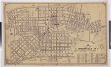
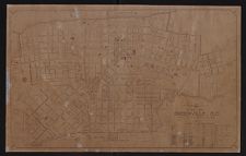
Map of Greenville, N.C.
- Title
- Map of Greenville, N.C.
- Description
- Scale [ca. 1:4,860]. Shows wards, street names, and points of interest. Includes index. Marked with concentric circles showing distance from the center of town. Notes: "Population 1930--10,168." "Source: Greenville City Public Works Dept."--Handwritten note on map. "Donated to Geog. Dept. Map Library by: John Ewald Nov. 1971."--Handwritten note on map.
- Date
- June 1933
- Original Format
- maps
- Extent
- 21cm x 27cm
- Local Identifier
- G3904.G8 F7 1930 .M37
- Subject(s)
- Spatial
- Location of Original
- Joyner NC Maps
- Rights
-
This item has been made available for use in research, teaching, and private study. Researchers are responsible for using these materials in accordance with Title 17 of the United States Code and any other applicable statutes. If you are the creator or copyright holder of this item and would like it removed, please contact us at als_digitalcollections@ecu.edu.
http://rightsstatements.org/vocab/InC-EDU/1.0/ - Permalink
- https://digital.lib.ecu.edu/1034
- Preferred Citation
- Cite this item
- This item
-
 Map of Greenville, N.C.
- My Collections Login
- Printable Feedback Form


Related Search Results

Public access is provided to these resources to preserve the historical record. The content represents the opinions and actions of their creators and the culture in which they were produced. Therefore, some materials may contain language and imagery that is outdated, offensive and/or harmful. The content does not reflect the opinions, values, or beliefs of ECU Libraries.
Contact Digital Collections
If you know something about this item or would like to request additional information, click here.
Comment on This Item
Complete the fields below to post a public comment about the material featured on this page. The email address you submit will not be displayed and would only be used to contact you with additional comments or questions.