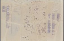
Map of Saint Paul's Episcopal Churchyard. Edenton, NC.
- Title
- Map of Saint Paul's Episcopal Churchyard. Edenton, NC.
- Description
- Cemetery map with handwritten research notes. This item is too large for the scanning bed, but efforts were made to include all printed areas of the map. Adjustments to the scanned image have been made to increase readability. - mid 20th century
- Extent
- 92.23cm x 59.97cm
- Local Identifier
- 1215-s11-fos3
- Location of Original
- East Carolina Manuscript Collection
- Permalink
- https://digital.lib.ecu.edu/65659
- Preferred Citation
- Cite this item
- This item
-
 Map of Saint Paul's Episcopal Churchyard. Edenton, NC.
- My Collections Login
- Printable Feedback Form
- Location of Original
- Elizabeth Vann Moore Papers from the East Carolina Manuscript Collection
- View all digitized items from the Elizabeth Vann Moore Papers
Related Search Results

Public access is provided to these resources to preserve the historical record. The content represents the opinions and actions of their creators and the culture in which they were produced. Therefore, some materials may contain language and imagery that is outdated, offensive and/or harmful. The content does not reflect the opinions, values, or beliefs of ECU Libraries.
Contact Digital Collections
If you know something about this item or would like to request additional information, click here.
Comment on This Item
Complete the fields below to post a public comment about the material featured on this page. The email address you submit will not be displayed and would only be used to contact you with additional comments or questions.