A New and Correct Map of the Province of North Carolina (Moseley Map)
- Title
- A New and Correct Map of the Province of North Carolina (Moseley Map)
- Description
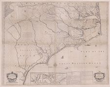
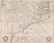
- A new and correct map of the Province of North Carolina by Edward Moseley, late surveyor general of the said province ([London]: Sold at the Three Crowns, 1733). Shows settlements, inhabitants, soil conditions, rivers, and principal products, with insets showing Port Brunswick or Cape Fear Harbour, Port Beaufort or Topsail Inlet, Ocacock [Ocracoke] Inlet, Explanation, and Directions for Ocacock [Ocracoke] Inlet.
- Date
- 1733
- Extent
- 146cm x 116cm
- Local Identifier
- MC0017
- Permalink
- https://digital.lib.ecu.edu/62315
- Preferred Citation
- Cite this item
- This item
-
 A New and Correct Map of the Province of North Carolina (Moseley Map)
- My Collections Login
- Printable Feedback Form
Related Search Results


Public access is provided to these resources to preserve the historical record. The content represents the opinions and actions of their creators and the culture in which they were produced. Therefore, some materials may contain language and imagery that is outdated, offensive and/or harmful. The content does not reflect the opinions, values, or beliefs of ECU Libraries.
Contact Digital Collections
If you know something about this item or would like to request additional information, click here.
Comments
That's my great-great-grandfather about six times back
Comment on This Item
Complete the fields below to post a public comment about the material featured on this page. The email address you submit will not be displayed and would only be used to contact you with additional comments or questions.
As someone researching early Welsh settlers in NC, this map illustrates where they set up home and just how numerous they were - in addition to the two Welsh settlements marked on the map, there are many obviously Welsh names listed as landholders.