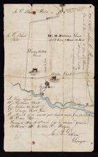
Surveyor's Map of W. H. Fortescue's Land in Hyde Co., N.C.
- Title
- Surveyor's Map of W. H. Fortescue's Land in Hyde Co., N.C.
- Description
- An illustrated manuscript surveyor's map (1848) done by James F. Latham showing boundaries of W.H. Fortescue's land in Hyde Co., N.C., found in the Credle Family Papers #532. Shows roads, landownership, Slader Creek, and other landmarks such as houses and trees. Note indicates the map was done "for a division between William H. & John E. Fortescue." Another note reads "William H. Fortescue to John E. Fortescue, 100 acres, Dec. 5, 1849." No scale given.
- Date
- March 18, 1848
- Original Format
- maps
- Extent
- 19cm x 31cm
- Local Identifier
- 0532-b1-fc
- Creator(s)
- Subject(s)
- Spatial
- Location of Original
- East Carolina Manuscript Collection
- Rights
-
This item has been made available for use in research, teaching, and private study. Researchers are responsible for using these materials in accordance with Title 17 of the United States Code and any other applicable statutes. If you are the creator or copyright holder of this item and would like it removed, please contact us at als_digitalcollections@ecu.edu.
http://rightsstatements.org/vocab/InC-EDU/1.0/ - Permalink
- https://digital.lib.ecu.edu/37533
- Preferred Citation
- Cite this item
- This item
-
 Surveyor's Map of W. H. Fortescue's Land in Hyde Co., N.C.
- My Collections Login
- Printable Feedback Form
- Location of Original
- Credle Family Papers from the East Carolina Manuscript Collection
- View all digitized items from the Credle Family Papers
Related Search Results

Public access is provided to these resources to preserve the historical record. The content represents the opinions and actions of their creators and the culture in which they were produced. Therefore, some materials may contain language and imagery that is outdated, offensive and/or harmful. The content does not reflect the opinions, values, or beliefs of ECU Libraries.
Contact Digital Collections
If you know something about this item or would like to request additional information, click here.
Comments
Comment on This Item
Complete the fields below to post a public comment about the material featured on this page. The email address you submit will not be displayed and would only be used to contact you with additional comments or questions.
This map shows a "church" according to the High Tides (Volume 16 No.1, spring 1995) which is the former location of St. John's Episcopal Church before it was moved via barge in about 1909 to its current Sladesville. There are references to a church as early as 1743 in this area. I am also hoping to find the map which shows the earlier St. John's on Chapel Creek (previously Moses Creek). The church shown here was rebuilt using remaining sound timbers about 1875 by Mr. Fortescue and M. Makely. A graveyard still exists at this site. The High Tides (spring 2015, Vol. 36No.1) discusses 300 years of Anglicanism in Hyde and gives more detail.