Soil Survey
Series 1935, No. 3. Issued November 1938
Carteret County
North Carolina
By
S. O. PERKINS, in Charge, and M. W. BECK
United States Department of Agriculture
and
E. F. GOLDSTON, J. A. SUTTON, and
WILLIAM GETTYS
North Carolina Department of Agriculture and
North Carolina Agricultural Experiment Station
[Illustration:
United States Department of Agriculture 1862 Agriculture is the Foundation of Manufacture and Commerce 1889
Seal of the United States Department of Agriculture]
UNITED STATES DEPARTMENT OF AGRICULTURE
BUREAU OF CHEMISTRY AND SOILS
In cooperation with the
North Carolina Department of Agriculture and
North Carolina Agricultural Experiment Station
For sale by the SUPERINTENDENT OF DOCUMENTS, WASHINGTON D. C.
Price 40 cents
BUREAU OF CHEMISTRY AND SOILS
HENRY G. KNIGHT, Chief
W. W. SKINNER, Assistant Chief
F. L. TEUTON, Chief, Information Division
Soil Survey DivisionCHARLES E. KELLOGG, Chief
W. E. HEARN, Inspector, District 2
J. W. McKERICHER, in Charge Map Drafting
CooperationNorth Carolina Department of Agriculture
W. A. GRAHAM, Commissioner
and
North Carolina Agricultural Experiment Station
R. Y. WINTERS, Director
C. B. WILLIAMS, in Charge Soil Survey
CONTENTS| Page | |
| County surveyed | 1 |
| Climate | 3 |
| Agricultural history and statistics | 4 |
| Soil-survey methods and definitions | 7 |
| Soils and crops | 8 |
| Light-colored well-drained soils | 9 |
| Norfolk fine sandy loam | 10 |
| Norfolk fine sandy loam, deep phase | 11 |
| Norfolk fine sand | 12 |
| Craven fine sandy loam | 13 |
| Craven fine sandy loam, flat phase | 14 |
| Dunbar fine sandy loam | 14 |
| Light-colored imperfectly drained soils | 15 |
| Onslow fine sandy loam | 15 |
| Onslow loamy fine sand | 16 |
| Bladen fine sandy loam | 16 |
| Bladen fine sandy loam, low phase | 17 |
| Plummer fine sandy loam | 18 |
| Black poorly drained soils | 18 |
| Portsmouth fine sandy loam | 19 |
| Portsmouth fine sandy loam, swamp phase | 19 |
| Portsmouth loam | 20 |
| Bayboro loam | 20 |
| Hyde loam | 21 |
| Organic soils | 21 |
| Pamlico muck | 22 |
| Pamlico muck, shallow phase | 22 |
| Peat | 23 |
| Miscellaneous soils and land types | 23 |
| Blanton fine sand | 23 |
| Portsmouth fine sand | 24 |
| Leon fine sand | 24 |
| St. Johns fine sand | 25 |
| St. Lucie fine sand | 25 |
| Swamp | 26 |
| Tidal marsh | 26 |
| Coastal beach | 27 |
| Coastal beach, scrub phase | 27 |
| Land uses and agricultural methods | 27 |
| Morphology and genesis of soils | 29 |
| Summary | 33 |
| Map. |
SOIL SURVEY OF CARTERET COUNTY, NORTH CAROLINA
By S. O. PERKINS, in Charge, and M. W. BECK, United States Department of Agriculture, and E. F. GOLDSTON, J. A. SUTTON, and WILLIAM GETTYS, North Carolina Department of Agriculture and North Carolina Agricultural Experiment Station
COUNTY SURVEYEDCarteret County is in the southeastern part of North Carolina, its eastern and southern boundaries bordering the Atlantic Ocean (fig. 1). Beaufort, the county seat, is 135 miles southeast of Raleigh, the State capital. The county is very irregular in outline, being cut by large short tidal streams, bays, and sounds. The total land area is 532 square miles, or 340,480 acres.
[Illustration:
Figure 1.—Sketch map showing location of Carteret County, N. C.
]
The relief in general is that of a low flat plain, broken only by narrow shallow valleys. The most noticeable features are the gently rolling or undulating areas which extend inland from the mouths of streams for a few hundred feet to a mile or more. In a few places along Bogue Sound, bluffs rise from 5 to 15 feet above sea level. The areas bordering the marsh near the mouth of Hunters Creek, along Bogue Sound, Whiteoak River and its small tributaries, and along part of Newport River and Core Creek have a more rolling relief than elsewhere in the county. The intervening areas have an undulating to flat relief broken only by small slight ridges, hummocks, and depressions. The banks along the ocean in most places are very hummocky and dunelike, except on Portsmouth Island and Core Banks, where they are nearly level. In the northern, northeastern, and northwestern parts of the county are extensive areas of almost level land which include the great Open Grounds and Lakes Pocosin. These large nearly level areas have an almost imperceptible gradient from the center outward. Many smaller flat areas occur near the sources of streams.
The elevation ranges from sea level to about 30 feet above. The highest point in the county is probably in the vicinity of Stella. The elevation at Beaufort is 10 feet above sea level.
Drainage is effected through Whiteoak, Newport, North, Neuse, and South Rivers, and short tidal streams. Part of the upland near
the streams, especially along Bogue Sound and Whiteoak River is naturally well drained, but on practically every farm ditches are necessary to carry off the surplus water. There are no natural drainageways in the pocosins and other flats. Owing to their low position and lack of natural drainage outlets, the swamps and marshes cannot be drained and are covered with water at intervals throughout the year. The stream valleys are narrow and the streams are sluggish, but in the earlier days some of the streams furnished enough power to run gristmills, the sites of which are marked by old dams and mills. The streams rise at an elevation of 10 feet below the general level of the upland, and their mouths are at sea level. The entire northeastern half of the county is so low and flat that during the storm of September 1933 water from Neuse River and Pamlico Sound covered all that part of the county to a depth ranging from 3 to 8 feet.
In the eastern part of the county is a large area of treeless land, locally known as the Open Grounds, now owned by the University of Chicago. Several years ago an attempt was made to reclaim this land. Canals and ditches were dug at considerable expense, but the project has been abandoned. This large open treeless area has never been forested, according to information from the earlier settlers. It does, however, support a thick undergrowth of titi, baybushes, gallberry bushes, coarse grasses, and in some places bamboo and reeds.
Most of the forested areas have been cut over and the trees are being replaced by young pines. The original forest on the well-drained areas consisted principally of longleaf pine and a few loblolly pine, and in a few places a good growth of these trees is found. In some of the less well drained areas, most of the tree growth consists of loblolly pine with some pond pine and longleaf pine. In the pocosins and bordering the Open Grounds, the principal growth is a gnarly topped pine. The hardwood growth is negligible and includes only a few small red, white, post, and scrub oaks, hickory, dogwood, beech, and maple. Sweetgum, tupelo gum, and some cypress, poplar, ash, swamp maple, birch, and water oak comprise the tree growth on the more swampy areas. There is an undergrowth of baybushes, myrtle, gallberry, some holly, and various kinds of briers on nearly all the forested areas.
Carteret County was one of the original precincts of the Lords Proprietor and derived its name from one of them, Sir George Carteret. The earliest settlements in the county were made between 1700 and 1710. The settlers were mostly English, French Huguenots, and some Welsh Quakers. The present population consists of their descendants and persons who have migrated from other parts of the State and from Virginia.1
The 1930 census reports the population of the county as 16,900, of which 10,460 are classed as rural. The average density of the rural population is 18.2 persons a square mile. Native whites constitute 84.7 percent, Negroes 15 percent, and foreign-born whites 0.3 percent. The population is very unevenly distributed, as practically all the inhabitants live within a mile of navigable waters. The most
[note]thickly populated part is along United States Highway No. 70 from Newport to Morehead City and from Beaufort to Atlantic, and in the vicinities of Marshallburg, Straits, Gloucester, Harkers Island, Roe, Stacy, Davis, Bogue, and Stella.
Beaufort, with a population of 2,957, is the county seat. Morehead City, with a population of 3,483, is the largest town in the county and lies just across Newport River from Beaufort. Other important towns are Atlantic with a population of 685 and Newport with 481. Marshallburg, Davis, Sealevel, Stacy, Stella, and Smyrna are important trading centers.
Transportation facilities are good. Nearly every section is within easy reach of a railroad station, hard-surfaced road, or water transportation. The Atlantic, North Carolina and the Norfolk Southern Railroads extend into the county through Newport and Morehead City to Beaufort. Transportation for the northeastern part is by bus, truck, or boat. The county is also well supplied with highways. United States Highway No. 70 enters the northwestern part and passes through Newport, Morehead City, Beaufort, and along Core Sound to Atlantic. A State highway enters near the mouth of Whiteoak River, runs along the southern side, and intersects with the Federal highway just west of Morehead City. Another State highway extends from Beaufort to Harlowe Church and continues to New Bern in Craven County. These three roads are hard-surfaced with sand asphalt. The few secondary roads are kept in fairly good repair. The inland waterway passes through Bogue Sound and between Morehead City and Beaufort, up Core Creek, into Adams Creek, and thence into Neuse River. This waterway affords transportation for the county as well as passage for private yachts and boats playing between Florida and the North.
Schools and churches are within easy access of everyone. Most of the schools are consolidated and have modern buildings. Telephone service is available in most sections. Either star or rural free delivery mail routes extend to all parts.
There are several lumber mills in the county, the largest of which is in Beaufort. Several mills manufacture fish and crab boxes. Factories for manufacturing fish scrap, fish meal, and fish oil are located near Beaufort and Morehead City.
The shipping of fish, crabs, clams, scallops, and oysters is an important business and the main source of income of a large part of the population on Cedar Island, in the section between Atlantic and Davis, on Harkers Island, and in Portsmouth, Salter Path, and Lukens. As many as 200,000 pounds of fish are shipped out of Beaufort in 1 week. Richmond, Washington, Baltimore, Philadelphia, and New York are the principal northern markets. Considerable revenue is derived in Beaufort and Morehead City from summer visitors. The people around Davis, Cedar Island, and other places along the sounds receive some revenue for accommodating hunters during the open season of migratory birds.
CLIMATEOwing to the proximity of the Atlantic Ocean, the climate of Carteret County is mild throughout the year. The sea breezes along the coast during the hot summer and the mild winters make this an ideal climate. Cover crops and hardy vegetables can be grown during
the winter, and outdoor work can be carried on. The ground very seldom freezes and then only a thin crust forms which thaws very quickly. The snowfall is very light and lasts only a short time. Broccoli, turnip tops, and cabbage can be grown successfully during the winter. Truck crops, such as early cabbage, English peas, potatoes, beets, string beans, and tomatoes, are profitable early spring crops. As many as two, and sometimes three, crops are produced on the same land in 1 year.
The average annual rainfall is 51.26 inches. It is well distributed throughout the year, being heaviest during the growing season.
The frost-free period, between the average last killing frost in the spring (Mar. 8) and the average first in the fall (Dec. 3), is 270 days, or almost 9 months. Frost has been recorded as early as November 2 and as late as April 15.
Table 1, compiled from the records of the United States Weather Bureau station at Beaufort, gives the more important climatic data for Carteret County.
| Temperature | Precipitation | ||||||
| Month | Mean | Absolute maximum | Absolute minimum | Mean | Total amount for the driest year (1911) | Total amount for the wettest year (1908) | Snow, average depth |
| °F. | °F. | °F. | Inches | Inches | Inches | Inches | |
| December | 49.1 | 73 | 8 | 4.41 | 4.70 | 4.95 | 0.8 |
| January | 48.1 | 73 | 4 | 3.96 | 2.37 | 4.80 | .6 |
| February | 48.4 | 71 | 13 | 4.03 | .95 | 5.00 | .2 |
| Winter | 48.5 | 73 | 4 | 12.40 | 8.02 | 14.75 | 1.6 |
| March | 53.5 | 83 | 24 | 3.95 | 4.16 | 6.08 | 1 |
| April | 61.1 | 83 | 32 | 3.27 | 1.80 | 4.27 | .0 |
| May | 69.5 | 92 | 45 | 3.45 | 1.26 | 11.07 | .0 |
| Spring | 61.4 | 92 | 24 | 10.67 | 7.22 | 21.42 | .0 |
| June | 76.3 | 97 | 53 | 4.65 | 1.72 | 2.81 | .0 |
| July | 79.9 | 96 | 60 | 6.05 | 1.91 | 12.33 | .0 |
| August | 79.5 | 96 | 62 | 5.44 | 4.73 | 11.49 | .0 |
| Summer | 78.6 | 97 | 53 | 16.14 | 8.36 | 26.63 | .0 |
| September | 76.1 | 95 | 50 | 4.75 | 3.65 | 5.39 | .0 |
| October | 66.7 | 87 | 37 | 4.41 | 3.49 | 10.73 | .0 |
| November | 56.7 | 78 | 24 | 2.89 | 2.03 | 1.89 | 1 |
| Fall | 66.5 | 95 | 24 | 12.05 | 9.17 | 18.01 | .0 |
| Year | 63.7 | 97 | 4 | 51.26 | 32.77 | 80.81 | 1.6 |
| 1 Trace. |
Agriculture and fishing have been the chief occupations since the first permanent settlement. Agriculture began about 1700 and was confined to the better drained soils near the mouths of the streams and sounds and to areas where drainage could be effected by open ditches. The early agriculture consisted of the production of corn, wheat, rice,
and oats for subsistence crops, and sweetpotatoes and some potatoes and cotton for cash crops. Cattle, sheep, and hogs were raised. From the earliest reports, there were a large number of marsh ponies on the marshes and banks bordering the Atlantic Ocean. Practically all the ponies were drowned in the storm of September 1933. The production of lumber, tar, pitch, and turpentine constituted an important industry. Turpentine, pitch, tar, rosin, corn, rice, cotton, lumber, and piling were the principal products exported. About 1900 the production of pitch, tar, and turpentine ceased, owing to the resources being practically exhausted, but the lumber industry has continued.
According to the 1935 Federal census, land in farms included 17 percent of the area of the county, or 62,330 acres, of which 17,549 acres were cropland or plowable pasture, 2,208 acres woodland pasture, 1,080 acres other pasture, 34,221 acres woodland not pastured, and 7,272 acres other land. There were 885 farms, and their average size was 70.4 acres. Of these, 601 ranged from 3 to 49 acres and 3 included 1,000 or more acres. In addition, there are some large landholdings and a few large timber holdings comprising several thousand acres. The Federal Government has recently acquired over 30,000 acres of forest and cut-over land in the southwestern part of the county for a national forest.
According to the 1880 Federal census the leading crops, in order of their acreages, were corn, cotton, sweetpotatoes, wheat, and rice. The present-day agriculture is based on the production of corn, hay, sweetpotatoes, potatoes, peanuts, soybeans, tobacco, cotton, and truck crops. The tobacco, cotton, truck crops, potatoes, and sweetpotatoes are cash crops. Table 2 gives the acreages of the principal crops for the census years from 1879 to 1934, inclusive.
| Crop | 1879 | 1889 | 1899 | 1909 | 1919 | 1929 | 1934 |
| Acres | Acres | Acres | Acres | Acres | Acres | Acres | |
| Corn | 5,156 | 6,618 | 5,575 | 5,567 | 4,478 | 4,299 | 4,852 |
| Sweetpotatoes | 834 | 1,253 | 787 | 1,286 | 1,050 | 1,417 | 1,740 |
| Peanuts | 334 | 519 | 1,227 | 41 | 1,352 | 1,493 | |
| Potatoes | 81 | 204 | 128 | 530 | 1,200 | 1,535 | |
| Soybeans | 180 | 1,232 | 1,068 | ||||
| Tobacco | 1 | 172 | 291 | 991 | 1,719 | 1,007 | |
| Cotton | 2,936 | 2,600 | 1,408 | 2,343 | 3,849 | 969 | 587 |
| Hay | 49 | 74 | 247 | 915 | 541 | 2,153 | 2,496 |
The acreage in corn has been fairly constant since 1879, but the acre yield has increased. In 1934, 59,641 bushels of corn were obtained from 4,852 acres. It is grown to greater or less extent on all the cultivated soils. It is used mainly as a subsistence crop to feed the work animals, to fatten hogs, and to be ground into meal for home use. A little is sold for cash.
The acreage in cotton has decreased considerably; only 587 acres were planted in 1934, yielding 356 bales. Cotton yields in this county are higher than the average for the State.
The production of tobacco has steadily increased. In 1934 this crop was grown on 1,007 acres which yielded 766,080 pounds. Tobacco is grown on the light-colored well-drained soils in the western part of the county.
About $400,000 annually is derived from the sale of sweetpotatoes, potatoes, cabbage, tomatoes, turnip tops, broccoli, snap beans, English peas, watermelons, and cantaloups. Cabbage and tomato plants also are sold. Most of the truck crops are grown in the vicinity of Beaufort, near Morehead City, and in the North River section.
In 1879 only 49 acres were devoted to hay. In 1934 this crop was grown on 2,496 acres which yielded 2,003 tons. The recent expansion is owing to an increase in the number of cattle. Most of the hay is obtained from legumes. Legumes for hay were grown on 2,306 acres and yielded 1,844 tons in 1934. Soybeans became an important crop in 1919. They were grown on 1,068 acres and yielded 8,409 bushels in 1934.
Practically no rice and very little wheat has been grown since 1900. The production of potatoes, sweetpotatoes, and peanuts has steadily increased. The acreage in vegetables, other than potatoes and sweetpotatoes, has likewise increased, and in 1934 watermelons, cabbage, snap beans, and tomatoes for sale were produced on 546, 508, 418, and 81 acres, respectively. English peas, broccoli, and turnip tops are also grown.
In 1935 there were 282 horses, 708 mules, 1,473 cattle, 255 sheep, 4,039 hogs, and 27,537 chickens on farms. The number of cattle was considerably greater than that reported in 1930 although not so great as the number in 1920. Some hogs and poultry are shipped out of the county.
Three small dairies are located in the vicinities of Beaufort and Morehead City. The milk supply seems to be sufficient for local demands. Most of the dairy cows are Jerseys and Guernseys.
Table 3 gives the value of all agricultural products, by classes, in 1929.
| Crop | Value | Livestock and products | Value |
| Cereals | $70,023 | Domestic animals | $189,918 |
| Other grains and seeds | 34,409 | Dairy products sold | 28,128 |
| Hay and forage | 41,034 | Poultry and eggs | 72,404 |
| Vegetables (including potatoes and sweetpotatoes) | 395,753 | Wool | 72 |
| Fruits and nuts | 10,823 | Total | 290,522 |
| Farm garden vegetables (excluding potatoes and sweetpotatoes) for home use only | 25,618 | Total agricultural products | 1,135,211 |
| All other field crops | 229,363 | ||
| Forest products for home use and for sale | 37,666 | ||
| Total | 844,689 |
Fertilizer is in general use by all the farmers, and most of it is bought ready mixed. In 1929 fertilizers were used on farms reporting an expenditure of $131,130, or an average of $194.47 a farm. The principal grade used for tobacco is a 3-8-52 mixture, for corn 4-8-4, cotton 3-8-3, watermelons and cantaloups 3-8-6, cabbage 6-6-6 with a side dressing of nitrate of soda, potatoes 5-7-5 or 6-6-5, sweetpotatoes 3-8-8, and snap beans 5-7-5. Land plaster is used for peanuts.
[note]Burnt or ground oystershells are used by some farmers for corn, hay, and cotton.
During 1929 feed was purchased on 312 farms at a total cost of $30,578, or an average of $98 a farm.
Farm laborers, both white and Negro, were hired on 417 farms, and a total sum of $74,036 was paid in wages in 1929, or $177.54 a farm. Wages range from 75 cents to $1.25 a day. In most cases vegetable gatherers are paid by the piece or package, earning about $2.25 a day.
Owners operated 77.5 percent of the farms in 1935, tenants 21.8 percent, and managers 0.7 percent. A few of the farms are rented for cash, the rental ranging from $3 to $8 an acre. When land is rented on a share basis, the landowner furnishes the land and one-third of the fertilizer and receives one-third of the crop, and when the landlord furnishes the land, work animals, feed, implements, and one-half of the fertilizer and seed, he receives one-half of the crop.
Most of the farmhouses are substantial and kept in fairly good repair, but most of the tenant houses are small. The better farmers have barns sufficiently large to shelter the livestock and store some hay and grain. They also have outbuildings for storage of machinery. There are a few tractors in the county.
SOIL-SURVEY METHODS AND DEFINITIONSSoil surveying consists of the examination, classification, and mapping of soils in the field.
The soils are examined systematically in many locations. Test pits are dug, borings are made, and exposures, such as those in road or railroad cuts, are studied. Each excavation exposes a series of distinct soil layers, or horizons, called, collectively, the soil profile. Each horizon, as well as the parent material, is studied in detail; and the color, structure, porosity, consistence, texture, and content of organic matter, roots, gravel, and stone are noted. The reaction of the soil,3 and its content of lime and salts are determined by simple tests in the field. Drainage, both internal and external, and other external features, such as the relief, or lay of the land, are taken into consideration, and the interrelation of the soils and vegetation are studied.
The soils are classified according to their characteristics, both internal and external, special emphasis being given to those features influencing the adaptation of the land for the growing of crops, grasses, and trees. On the basis of these characteristics, the soils are grouped into classification units. The three principal ones are (1) series, (2) type, and (3) phase. Areas of land, such as swamp or coastal beach which have no true soil, are called (4) miscellaneous land types.
The most important of these groups is the series, which includes soils having the same genetic horizons similar in their important characteristics and arrangement in the soil profile, and developed from a particular type of parent material. Thus the series includes soils having essentially the same color, structure, and other important internal characteristics, and the same natural drainage conditions
[note]and range in relief. The texture of the upper part of the soil, including that commonly plowed, may vary within a series. The soil series are given names of places or geographic features near which they were first found. Thus, Norfolk, Craven, Bladen, and Portsmouth are names of important soil series in this county.
Within a soil series are one or more soil types, defined according to the texture of the upper part of the soil. Thus, the class name of the soil texture, such as sand, loamy sand, sandy loam, loam, silt loam, clay loam, silty clay loam, and clay, is added to the series name to give the complete name of the soil type. For example, Portsmouth fine sandy loam and Portsmouth loam are soil types within the Portsmouth series. Except for the texture of the surface soil, these soil types have approximately the same internal and external characteristics. The soil type is the principal unit of mapping and because of its specific character is usually the soil unit to which agronomic data are definitely related.
A phase of a soil type is recognized for the separation of soils within a type which differ in some minor soil characteristic which may, nevertheless, have an important practical significance. Differences in relief, stoniness, and the degree of accelerated erosion are frequently shown as phases. For example, within the normal range of relief for a soil type, there may be parts which are adapted to the use of machinery and the growth of cultivated crops and other parts which are not. Even though there may be no important differences in the soil itself or in its capability for the growth of native vegetation throughout the range in relief, there may be important differences in respect to the growth of cultivated plants. In such an instance the more sloping areas of a soil type may be segregated on the map as a sloping or hilly phase. Similarly, soils having differences in stoniness may be mapped as phases, even though these differences are not reflected in the character of the soil or in the growth of native plants.
The soil surveyor makes a map of the county or area, showing the location of each of the soil types, phases, and miscellaneous land types, in relation to roads, houses, streams, lakes, section and township lines, and other local cultural and natural features of the landscape.
SOILS AND CROPSSome of the land that was farmed 40 or 50 years ago, evidence of which can be seen in traces of old corn and cotton rows, is now reforested. This is particularly noticeable in the Merrimon section.
There is a vast area of open muck land on which no trees have grown since white men settled the country. There are large areas of tidal marsh, particularly in the northeastern part of the county, and many smaller areas are along North, Newport, South, and Neuse Rivers. Parts of two large pocosins extend into the northwestern and northeastern parts. Large areas of fine sand lie along and north of the State highway extending from Whiteoak River to Morehead City and in the vicinity of Atlantic. None of the above-mentioned areas is cleared or farmed. Practically all of the original timber growth was cut a long time ago, and a large part of the second growth is now being cut.
Most of the land is forested land, cut-over land, open grounds, tidal marsh, or coastal beach. Only a small proportion of the land
is cultivated, principally in the vicinity of Newport, south of the State highway along Bogue Sound, in the vicinities of Morehead City and Merrimon, along the State highway between Beaufort and Harlowe Church, and in a narrow strip bordering United States Highway No. 70 from Beaufort to Atlantic in the vicinities of Marshallburg, Straits, and Stella, and along Adams Creek.
The great drawback to farming is that nearly all of the productive soils lie only a few feet above sea level and have a high water table. Because of these features, crops are drowned in some seasons. Large areas of soils potentially good for cultivated crops and pastures could be reclaimed and made good agricultural lands if they were drained. Farms are located wherever possible near some natural drainageway. Drainage of these lands can be effected by canals and open ditches only by community organization, since the individual cannot drain his land until some main drainageway has been established.
In many places a close relationship exists between agriculture and soils. The large number of soils in Carteret County, based on the characteristics of the soils and their agricultural use, may be placed in five groups as follows: (1) Light-colored well-drained soils, (2) light-colored imperfectly drained soils, (3) black poorly drained soils, (4) organic soils, and (5) miscellaneous soils and land types.
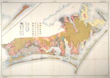
In the following pages of this report the soils are described in detail, and their agricultural relationships are discussed; their distribution is shown on the accompanying soil map; and table 4 gives their acreage and proportionate extent.
| Type of soil | Acres | Percent | Type of soil | Acres | Percent |
| Norfolk fine sandy loam | 1,920 | 0.6 | Bayboro loam | 3,136 | 0.9 |
| Norfolk fine sandy loam, deep phase | 1,344 | .4 | Hyde loam | 1,728 | .5 |
| Pamlico muck | 83,008 | 24.4 | |||
| Norfolk fine sand | 7,040 | 2.1 | Pamlico muck, shallow phase | 27,968 | 8.2 |
| Craven fine sandy loam | 7,936 | 2.3 | Peat | 1,024 | .3 |
| Craven fine sandy loam, flat phase | 768 | .2 | Blanton fine sand | 6,720 | 2.0 |
| Dunbar fine sandy loam | 1,152 | .3 | Portsmouth fine sand | 8,640 | 2.5 |
| Onslow fine sandy loam | 8,192 | 2.4 | Leon fine sand | 10,560 | 3.1 |
| Onslow loamy fine sand | 896 | .3 | St. Johns fine sand | 12,480 | 3.7 |
| Bladen fine sandy loam | 9,728 | 2.9 | St. Lucie fine sand | 1,792 | .5 |
| Bladen fine sandy loam, low phase | 2,176 | .6 | Swamp | 11,200 | 3.3 |
| Plummer fine sandy loam | 5,440 | 1.6 | Tidal marsh | 56,896 | 16.7 |
| Portsmouth fine sandy loam | 28,608 | 8.4 | Coastal beach | 13,952 | 4.1 |
| Portsmouth fine sandy loam, swamp phase | 3,648 | 1.1 | Coastal beach, scrub phase | 2,944 | .9 |
| Portsmouth loam | 19,584 | 5.7 | Total | 340,480 |
This group includes Norfolk fine sandy loam, Norfolk fine sandy loam, deep phase, Norfolk fine sand, Craven fine sandy loam, Craven fine sandy loam, flat phase, and Dunbar fine sandy loam. These soils cover nearly 6 percent of the total area of the county. They are the leading soils in the production of tobacco, sweetpotatoes, watermelons, and cotton. They occur near the larger streams in the southern and western parts and in the Merrimon section of the county. They border marshes and swamps along Newport, Neuse, and Whiteoak Rivers, and Adams Creek and their tributaries, and
occur along Bogue Sound. These soils occupy nearly level, gently rolling, and undulating areas, and their relief and the texture and structure of both the surface soil and subsoil afford good natural drainage. These soils lie well for agricultural purposes and for the use of all kinds of farm machinery.
Soils of this group have gray, grayish-brown, or light-brown surface soils which are uniformly of fine sand, loamy fine sand, and fine sandy loam texture. The surface soil of Dunbar fine sandy loam is somewhat darker than the corresponding layer of any other soil in the group. The subsoils range from yellow or reddish-yellow to reddish-brown friable fine sands or fine sandy clays. Nearly all of the subsoils are underlain by mottled yellow, light-red, and gray fine sandy clay parent material. These soils are deficient in organic matter, but they are mellow and friable and, therefore, are very easy to till. The subsoils are sufficiently friable to maintain good moisture conditions for growing plants.
Because of the texture of the surface soil, the friability of the subsoil, and good natural drainage, these soils warm early in the spring and are the first on which farming begins. Although they are naturally low in plant nutrients, their physical properties are so favorable that they respond readily to fertilization, and they produce as profitable crops as any soil in the county. All these soils are slightly acid, but this condition is corrected by the application of small quantities of lime, especially on land used for peanuts and other legumes.
A large part of this land is cleared and cultivated. These are considered the best soils in the county for the production of cotton, peanuts, watermelons, cantaloups, and some truck crops. All the tobacco grown in the county is produced on them.
All the original longleaf pine, loblolly pine, some second-growth pine, and other trees have been cut. The forest growth at present consists of old-field pine, loblolly pine, second-growth scrub pine, a few young longleaf pines, oaks, hickories, sweetgums, and dogwoods.
Norfolk fine sandy loam.—Norfolk fine sandy loam is considered the best soil in this group for the growing of bright-leaf tobacco, sweetpotatoes, cotton, English peas, cabbage, string beans, and beets. Because of its physical properties and good natural drainage, this soil probably is the most dependable one in the county. It responds readily to the application of commercial fertilizer and holds fertilizer and manure well. It is also retentive of moisture for the growing of crops. It can be built up to a fair state of productivity.
In cultivated fields the 6- or 8-inch surface layer is gray or grayish-brown fine sandy loam. It is underlain by a subsurface layer of pale-yellow fine sandy loam. The subsoil, which begins at a depth ranging from 10 to 15 inches, is yellow friable fine sandy clay and grades into mottled yellow, light-red, and gray fine sandy clay at a depth ranging from 24 to 30 inches. In this county the underlying parent material is nearer the surface than in the higher lying Coastal Plain counties, owing probably to the low elevation. In the less well drained areas or in places where this soil joins the Portsmouth or other poorly drained soils, gray mottlings appear in the subsoil at a depth ranging from 15 to 20 inches below the surface. In some of the more rolling areas, the subsoil is reddish-yellow or light-red
friable fine sandy clay and the depth to the mottled parent material is greater. These rolling areas would have been mapped as Ruston fine sandy loam had they occupied a larger acreage. In bodies adjoining the black Portsmouth soils, the surface soil is darker.
Norfolk fine sandy loam occurs in a few small scattered areas bordering drainageways, swamps, or marshes near Newport River in the vicinities of Newport and Wildwood. Other bodies are near Otway, Gloucester, and Marshallburg, and northeast of Beaufort.
Although Norfolk fine sandy loam is not extensive, it is an important agricultural soil. Probably 90 percent of the land is under cultivation. About 30 percent of the cultivated land is devoted to the production of bright-leaf tobacco; 30 percent to corn; 20 percent to sweetpotatoes, cabbage, and other vegetables; and 20 percent to cotton. This is one of the important soils for tobacco in the State. Yields in this county range from 700 to 1,000 pounds an acre when 1,000 pounds of a 3-8-5 fertilizer are applied. Corn yields from 20 to 25 bushels, with the use of 300 pounds of a 4-8-4 fertilizer. The average yield of sweetpotatoes is 135 bushels an acre, but as many as 275 bushels have been reported. Cabbage is fertilized with 1,500 pounds of a 6-6-6 grade of fertilizer and side-dressed with 200 pounds of nitrate of soda. Yields range from 4 to 5 tons an acre. Cotton receives 400 pounds of a 3-8-3 fertilizer and produces about one-half bale an acre. A small acreage is used for the production of snap, or string, beans, English peas, peanuts, and hay. Peanuts are usually hogged off. Some rye is grown for winter pasture and soil improvement.
Norfolk fine sandy loam, deep phase.—The deep phase of Norfolk fine sandy loam differs from the typical soil in that the depth to the yellow friable fine sandy clay subsoil is greater. The surface and subsurface layers in most places are lighter in color and prevailingly more sandy in the deeper soil. The subsurface layer continues downward to a depth ranging from 22 to 30 inches. The subsoil is thinner than it is under the typical soil, but it is underlain by the same kind of mottled fine sandy clay material.
There are only a few areas of this soil in the county, the largest of which are northwest and south of Peletier and northwest of Newport.
This soil occupies gently rolling to rolling areas near the breaks of stream courses, and the land is well drained; when cultivated it is subject to some erosion. The greater part of it is in forest consisting mainly of longleaf and loblolly pines, oak, dogwood, holly, and hickory. Probably not more than 25 percent of the land has been cleared. The principal crops grown are tobacco, peanuts, watermelons, and corn. The yield of tobacco ranges from 500 to 700 pounds an acre with an application of 1,000 pounds of a 3-8-5 fertilizer. Corn yields from 10 to 20 bushels an acre. Peanuts are usually hogged off. Some rye and cowpeas are sown for hay and for soil improvement.
This soil is not so well suited to general farming as is typical Norfolk fine sandy loam, but, with proper crop rotation and fertilization, fair yields of bright-leaf tobacco, corn, peanuts, and truck crops could be obtained.
Norfolk fine sand.—Norfolk fine sand is the most extensive Norfolk soil mapped in the county. In cultivated fields the surface soil of Norfolk fine sand is gray or grayish-brown mellow fine sand to a depth ranging from 8 to 12 inches. In wooded areas a thin layer of decayed leaves, twigs, and roots and a 2- or 3-inch layer of dark-gray fine sand cover the surface. At an average depth of 12 inches, the surface soil is underlain by yellow loose mellow fine sand which continues to a depth of more than 3 feet. Underlying this is bright-yellow, light-yellow, orange, or reddish-brown fine sand.
In places where this soil is associated with Blantonfine sand, the surface soil and subsoil are lighter in color, and in a few areas the surface soil is more brown and the subsoil reddish yellow. Along Bogue Sound where large quantities of sea shells have been deposited, the surface soil is dark gray or brown, due, probably, to the presence of lime which holds the organic matter. The lime in the soil has favored the growth of plants and grasses which are the source of organic matter in the soil. In slight depressions or level areas, where drainage is not so well established, the surface soil is dark gray and the subsoil grayish yellow. A few spots of Portsmouth fine sand and Norfolk loamy fine sand are included with mapped areas of this soil. South and west of Cedar Point and along Bogue Sound are small areas of Ruston fine sand which have been included with Norfolk fine sand. These areas have brown, light reddish-brown, or yellowish-brown surface soils and reddish-yellow or yellowish-red fine sand subsoils. Below a depth of 40 inches this fine sand in most places is yellow or brownish yellow, resembling the material under Norfolk fine sand. Practically all this included soil is cleared, and it is used for the production of watermelons, cantaloups, corn, and peanuts. All these crops are fertilized, and the yields are slightly higher than those obtained under similar treatment on Norfolk fine sand.
The largest areas of Norfolk fine sand lie west and southwest of Cedar Point and in one almost continuous body bordering Bogue Sound, between the State highway and the sound. Small areas are west of Newport and east of Merrimon.
The soil is exceptionally well drained. The land is level, undulating, or gently rolling. Owing to the openness of both surface soil and subsoil, the soil is somewhat droughty, but the fine texture and the incorporation of organic matter in the soil provide such good moisture-holding capacity that crops seldom suffer from drought.
Probably 80 percent of this soil is cleared, and the rest is in forest of longleaf and loblolly pines and a few small oak, dogwood, holly, hickory, and old-field pine. Old-field pine seems to make rapid growth on this soil.
Watermelons, cantaloups, corn, and peanuts are the principal crops grown. The famous Bogue Sound watermelons, which are said to have superior flavor to watermelons grown elsewhere in this section of the State, are grown on this soil. Due to blight, watermelons are planted on the same piece of land only once in every 4 to 7 years. Some farmers allow the land to lie idle or fallow during the intervening years, and others plant peanuts, corn, peas, and some truck crops. The dark-colored areas nearest to the sound,
which, on account of the deposits of shells, are not suited to watermelons, produce larger yields of peanuts and corn than any other areas of Norfolk fine sand.
Watermelons yield from 700 to 1,000 melons an acre, when 1,000 pounds of a 3-8-6 grade of fertilizer are used. Corn yields from 10 to 25 bushels when 300 pounds of a 3-8-3 fertilizer are applied. Most farmers add from 75 to 100 pounds of nitrate of soda an acre as a side dressing.
Craven fine sandy loam.—In cultivated fields the surface layer of Craven fine sandy loam is gray or brownish-gray fine sandy loam to an average depth of 7 inches. The subsurface layer is pale-yellow loamy fine sand or fine sandy loam. The subsoil, beginning at a depth ranging from 10 to 17 inches, is brownish-yellow or olive-drab tough slightly plastic clay or fine sandy clay which grades into mottled light-gray and brownish-yellow somewhat friable clay at a depth ranging from 25 to 30 inches. In wooded areas an inch or two of leafmold is on the surface. The parent material or the material underlying the subsoil is essentially the same as that under Norfolk fine sandy loam, that is, the subsoil grades into mottled yellow, light-red, and gray heavy fine sandy clay or clay. The heavy subsoil causes this soil to be less well drained than the Norfolk soil, although it is better drained than Dunbar fine sandy loam. Craven fine sandy loam does not warm so early in the spring as do the Norfolk soils. Therefore, it is not so well suited to truck crops, but the staple crops are not affected by these characteristics, because of the long growing season.
In places where this soil grades into Onslow fine sandy loam the surface soil is darker, and a few hard brown concretions are on the surface and mixed with the soil in cultivated fields. Small spots of Onslow fine sandy loam, Dunbar fine sandy loam, and Bladen fine sandy loam are included with Craven fine sandy loam as mapped. On some of the slopes or breaks there are spots which have more brown in the surface soil and a somewhat red heavy slightly plastic clay subsoil. Such areas would have been mapped as Cuthbert fine sandy loam had they been larger. One such spot is near Stella.
Craven fine sandy loam occurs in several small bodies widely distributed throughout the county, except the northeastern part. The largest areas are in the vicinity of Stella along Whiteoak River and Hunters Creek, in the vicinity of Merrimon along Adams Creek, along Newport River, and along Harlowe Creek. This soil is associated with the Norfolk, Onslow, Bladen, and Dunbar soils, and in cultivated fields the soil closely resembles Norfolk fine sandy loam.
This soil ranges in relief from gently rolling or sloping nearest to the streams or swamps to nearly level in places where it joins the Onslow, Dunbar, Bladen, or Portsmouth soils. Areas nearest the slopes, where the relief is more rolling or sloping, are subject to sheet erosion, and in places the yellow clay is at or near the surface.
Approximately 80 percent of this land is cleared. The remaining forest growth consists principally of oak, longleaf and loblolly pines, dogwood, hickory, holly, and beech. Gallberry and myrtle bushes form the undergrowth. About 45 percent of the farm land is in corn, soybeans, and peanuts, 30 percent in tobacco, 15 percent in cotton, 5 percent in sweetpotatoes and cabbage, and 5 percent in
other truck crops. Corn yields from 20 to 30 bushels an acre when 300 pounds of a 4-8-4 fertilizer are applied. Tobacco usually receives 1,000 pounds of a 3-8-5 mixture, and it yields from 600 to 1,000 pounds an acre. Cotton yields about one-half bale when 400 pounds of a 3-8-3 fertilizer is used.
Craven fine sandy loam is probably the best soil in the county for general farming. Before the infestation of the boll weevil, cotton yields were as high as 1 bale an acre.
Craven fine sandy loam, flat phase.—Craven fine sandy loam, flat phase, differs from the typical soil in that it has more nearly level or flat relief, is less well drained, and none of the land is cleared. The topmost surface layer consists of an inch or two of dark-gray fine sandy loam. It is underlain by a 4- or 6-inch layer of gray loamy fine sand or very fine sand. The subsurface layer is pale-yellow fine sandy loam. The subsoil, which begins at a depth ranging from 9 to 14 inches, is heavy plastic olive-drab clay, and below a depth of 25 to 30 inches it is mottled gray and yellow rather heavy fine sandy clay which is not plastic like the upper part of the subsoil. This flat soil occupies a small acreage in the northern part of the county in the vicinity of Merrimon. Because of the level relief and the heavy plastic subsoil, both surface and internal drainage are poor. All this land is in forest or is cut-over land. The principal trees are white, post, and water oaks, loblolly pine, maple, and some sweetgum and beech; and gallberry and myrtle bushes form the undergrowth.
This soil, owing to its high water table and impervious subsoil, should be left in forest or used for pasture.
Dunbar fine sandy loam.—In cultivated fields the surface layer of Dunbar fine sandy loam is gray or dark-gray light fine sandy loam 6 or 8 inches thick, and the 4- to 6-inch subsurface layer is pale-yellow friable fine sandy loam. The subsoil, to a depth ranging from 20 to 24 inches, is yellow rather heavy but friable fine sandy clay, below which the material is mottled yellow, gray, and in some places bright-red heavy slightly plastic fine sandy clay or clay. In virgin areas, the surface soil in most places is very dark gray fine sandy loam to a depth of 4 or 6 inches. In places, closely associated with the Onslow soils, a few brown concretions are scattered over the surface and mixed with the surface soil.
Dunbar fine sandy loam comprises only a few small areas. The largest body lies southeast of Lukens; several smaller bodies are around Otway, in the vicinity of Woodville Church, and in the vicinity of Whitehouse Forks in the western part of the county.
This soil occurs near small drainageways. The relief ranges from level to gently sloping. Surface drainage is fairly good, but internal drainage is rather poor. Owing to the low position of the land and the compact lower subsoil layer, or the material underlying the subsoil, open ditches are necessary in most areas to insure adequate drainage for farming.
Owing to its small extent this is not an important agricultural soil, and very little of it has been cleared for farming. The greater part is in forest consisting mainly of loblolly and longleaf pines, a few scrub oak, dogwood, sweetgum, and hickory, and there is an undergrowth of gallberry, myrtle bushes, and wire grass.
Most of the small cultivated acreage is used for truck and vegetable crops. Crop yields and fertilizer treatment are about the same as on the associated Norfolk and Onslow soils. Dunbar fine sandy loam is better suited for forestry or pasture than for cultivated crops.
LIGHT-COLORED IMPERFECTLY DRAINED SOILSIncluded in this group are Onslow fine sandy loam, Onslow loamy fine sand, Bladen fine sandy loam, Bladen fine sandy loam, low phase, and Plummer fine sandy loam. The surface soils are gray or dark gray, but the subsoils are markedly different in texture, structure, and consistence. The subsoils of the Onslow soils are characterized by a so-called hardpan, or iron crust, those of the Bladen soils by a distinctly heavy plastic clay or fine sandy clay; and those of the Plummer soil by friable fine sandy loam, fine sandy clay, or loamy fine sand.
These soils have a level to undulating relief and are naturally poorly drained or imperfectly drained. Very little of Plummer fine sandy loam has been used for agriculture, whereas a considerable acreage of the Bladen and Onslow soils is devoted to the production of staple and special crops.
Bladen fine sandy loam is inherently a good soil. When drained and properly handled, it produces good yields of the staple crops and is well suited to the production of potatoes and soybeans.
Onslow fine sandy loam.—In cultivated fields, the surface soil of Onslow fine sandy loam is somewhat darker than any of the soils in the light-colored group and is gray or dark-gray light-textured fine sandy loam 6 or 8 inches thick. In wooded or unplowed areas, a 2- to 6-inch layer of rust-brown or ocherous-yellow concretionary hardpan underlies the surface soil. This hard layer is locally called “sand rock.” It is composed of fine sand cemented with iron and organic matter. In wooded areas, the 1- to 2-inch surface soil is dark gray, owing to the presence of organic matter. The subsurface layer below the hardpan layer is pale-yellow or gray and yellow fine sandy loam to a depth ranging from 10 to 20 inches. The subsoil is brownish-yellow or olive-drab heavy fine sandy clay to a depth ranging from 28 to 40 inches. The underlying material is mottled gray, yellow, and light-red fine sandy clay or heavy clay.
In places the surface soil is shallow and the pale-yellow layer between the hardpan layer and the subsoil is very thin. In plowed areas most of the hardpan layer has been broken up by the plow and brought to the surface and mixed with the surface soil. This hard layer, when exposed, breaks up into small brown particles, giving the plowed fields a brown tinge. In some other places where the land is less well drained, the surface soil is darker and the subsoil is mottled yellow and gray rather heavy slightly plastic fine sandy clay.
The largest areas of this soil occur in the vicinity and north of Peletier. Other areas are near Newport, Wildwood, Morehead City, Beaufort, Woodville Church, Otway, Smyrna, Straits, Gloucester, and Marshallburg.
The relief ranges from level, or nearly level, to undulating, or very gently rolling. Owing to the level or nearly level relief, together
with the impervious hardpan and heavy subsoil, this soil in places is inadequately drained. In wooded virgin areas the hardpan does not allow free downward movement of water, and, during seasons of heavy rainfall, the water stands on the surface for a considerable time and on cultivated fields results in damage to crops.
Probably 85 to 90 percent of this soil is cleared, of which about 90 percent is cultivated and 10 percent is in pasture. This soil is used mostly for general farming in the western part of the county, whereas near Morehead City, Beaufort, Otway, and Marshallburg, it is used mainly for truck crops. Probably 40 percent of the farmed area in the western part of the county is used for corn, 25 percent for tobacco, 25 percent for cotton, and 10 percent for truck crops, such as potatoes, sweetpotatoes, cabbage, English peas, and snap beans.
The fertilizer treatment for this soil is as follows: 300 pounds an acre of 4-8-4 fertilizer for corn, 1,000 pounds of 3-8-5 for tobacco, 400 pounds of 3-8-3 for cotton, and 1,000 pounds of 3-8-8 for sweetpotatoes. When so fertilized corn yields about 25 bushels an acre, tobacco 700 to 900 pounds, cotton one-half bale, and sweetpotatoes about 200 bushels. Cabbage yields between 4 and 5 tons an acre if fertilized with 1,500 pounds of a 6-6-6 mixture. Following cabbage, the land is generally planted to late sweetpotatoes or corn without any additional fertilizer. Potatoes are also planted on this soil and followed by sweetpotatoes or corn.
Onslow loamy fine sand.—The surface soil of Onslow loamy fine sand is gray loamy fine sand, 6 or 8 inches deep, underlain by a 1- to 3-inch hard brown layer which, unlike that underlying Onslow fine sandy loam, varies considerably in thickness and hardness. This so-called hardpan layer is underlain by pale-yellow loamy fine sand to a depth ranging from 12 to 15 inches. This grades into brownish-yellow loamy fine sand or fine sandy loam, and, at a depth ranging from 30 to 35 inches, little clay material is present. In slight depressions the surface soil is dark gray and the underlying material is gray or yellow mottled with gray loamy fine sand.
The largest areas of this soil are in the vicinity and north of Peletier. Other areas are along the State highway bordering Bogue Sound southwest of Wildwood.
The relief is undulating to gently rolling, and drainage is fair to good. Only a small part of this soil is cleared and under cultivation. The principal forest growth is pine, post oak, and some white oak, dogwood, and holly.
Watermelons are the principal crop and give satisfactory yields on land where moisture conditions are favorable and heavy applications of fertilizer are made. All other crop yields are low. This soil is probably best suited to forestry.
Bladen fine sandy loam.—In cultivated fields the 6- to 9-inch surface soil of Bladen fine sandy loam when dry is gray or grayish-brown fine sandy loam and in less well drained areas is nearly black. The subsurface layer is light-gray fine sandy loam faintly mottled with rust brown to a depth ranging from 10 to 15 inches. This is underlain by a steel-gray or bluish-gray heavy plastic fine sandy clay or plastic clay mottled with yellow and ocherous brown to a depth of 40 or more inches. When dry the subsoil becomes hard
and cracks, but when wet it is plastic and sticky. In places the subsoil contains vertical streaks of dark-gray or nearly black silty material which was probably brought down from the surface soil through holes made by crawfish or water-loving insects at a time when this soil was wetter than it is at present or before it was drained for farming purposes.
In wooded areas the 4- to 6-inch surface soil is dark gray to nearly black, whereas the subsurface layer is light gray. The subsoil grades from a heavy clay with thin lenses of gray fine sand to a plastic clay.
Included with this soil are some areas in the vicinity of Merrimon which differ from the typical soil. In these areas the 3- to 6-inch surface soil is gray or dark gray and is underlain by a grayish-brown or brownish-gray fine sandy loam to a depth ranging from 10 to 15 inches. This grades into gray and yellowish-brown mottled sticky fine sandy clay. The subsoil layer is composed of thin lenses of gray fine sand and yellowish-brown plastic clay.
Bladen fine sandy loam occurs in fairly large areas in the northern, central, and western parts of the county. The largest bodies are near Merrimon, Sealevel, Davis, Harlowe Church, and Morehead City, west of Newport, northeast of Stella, along Harlowe and Core Creeks, and the western shore of North River.
Probably not over 20 percent of this soil has been cleared, owing to its low position and poor drainage. The forest growth consists chiefly of loblolly pine, black gum, sweetgum, holly, and a few water oaks and post oaks and myrtle, gallberry, and some baybushes.
About 55 percent of the cleared land is planted to corn, 25 percent to cotton, and 20 percent to vegetable crops including sweetpotatoes and potatoes. Corn yields from 20 to 40 bushels an acre, when an application of 300 pounds of a 4-8-4 fertilizer is applied, cotton one-half to three-fourths of a bale with an application of 400 pounds of a 3-8-3 fertilizer, potatoes from 40 to 70 barrels with an application of 2,000 pounds of a 5-7-5 fertilizer, sweetpotatoes 130 to 160 bushels with an application of 1,000 pounds of a 3-8-8 fertilizer, and cabbage about 5 tons an acre with an application of 1,500 pounds of a 6-6-6 fertilizer. When corn is planted following potatoes or cabbage no additional fertilizer is used. Bladen fine sandy loam is potentially a good agricultural soil and, with artificial drainage, more of it could be used advantageously.
The poorer drained areas of this soil should be used for pasture.
Bladen fine sandy loam, low phase.—This soil differs from the typical soil mainly in that it occupies a low position near the tidal marsh. The 10- to 15-inch surface soil of Bladen fine sandy loam, low phase, is dark-gray or nearly black heavy fine sandy loam to loam. The subsoil is heavy plastic clay or fine sandy clay and contains more brownish-yellow or yellow mottling than that underlying the typical soil.
This soil occupies a small total acreage. Bodies are north of Beaufort, southwest of Otway, north of Morehead City, and north of Merrimon and along Core Creek and the western shore of North River.
This soil grades into tidal marsh on one side and into Bladen fine sandy loam or the Portsmouth soils on the other. It occupies low
level permanently wet areas, and water stands on the surface part of the year. None of it is cultivated.
The forest growth consists mainly of scrub pine with an undergrowth of gallberry, myrtle, coarse grasses, and some rushes. This soil cannot be used for farming purposes as it lies from only a few inches to 1 or 2 feet above sea level. It cannot be drained without diking and pumping. This soil can be used for pasture and forestry.
Plummer fine sandy loam.—Plummer fine sandy loam has a surface layer of gray or light-gray light-textured fine sandy loam, from 6 to 15 inches deep. The subsoil is light-gray mottled with yellow friable or crumbly fine sandy clay or loamy fine sand to a depth of 38 or more inches. In wooded areas the 2- to 4-inch surface soil is dark gray, and in places the subsoil is gray fine sandy loam or loamy fine sand, whereas in other places, especially in the vicinity of Peletier, the subsoil is yellow (predominantly) and gray mottled fine sandy clay or loamy fine sand. The lower part of the subsoil is saturated with water, and in most places the underlying material is gray water-soaked fine sand.
Plummer fine sandy loam occurs mainly in the northwestern and northeastern parts of the county. The largest areas lie northeast of Merrimon between Stella and the Lake Pocosin. Smaller areas occur west of Newport, northeast of Wildwood, north of Morehead City, northeast of Beaufort, south and west of Otway, and north of Southwest Creek, a tributary of South River. These areas occur mainly on stream flats, in depressions, and on gentle slopes near swamps.
The relief is nearly flat to gently undulating, and drainage is poorly established. Most of this soil is waterlogged throughout the winter and in some places the greater part of the year.
Only a few small areas of Plummer fine sandy loam are cultivated. Garden vegetables and corn are the principal crops. The forested areas support scattered growths of pine, sweetgum, black gum, scrub oak, and water oak, and an undergrowth of gallberry, briers, reeds, and coarse grasses.
Plummer fine sandy loam is difficult to drain because ditch banks cave in badly. Even where this soil is drained and farmed, crop yields are very low. Its best use is for forestry and pasture.
BLACK POORLY DRAINED SOILSThis group comprises the black poorly drained soils of the county which have been mapped as Portsmouth fine sandy loam, Portsmouth fine sandy loam, swamp phase, Portsmouth loam, Bayboro loam, and Hyde loam, and occupy 88.6 square miles. The black color of these soils is caused by a large content of organic matter that has accumulated through the decay of vegetation over a long period when the land was in a swampy condition. These soils occupy level areas or very slight depressions in which natural drainage has not been established. They are naturally strongly acid and require heavy applications of lime. These soils also require artificial drainage to reclaim them for agricultural use. Such drainage can be effected in larger areas by district or community cooperation.
These soils are inherently rich in organic matter and are considered good soils, perhaps the best in the county, for the production of corn, soybeans, cabbage, and potatoes.
Portsmouth fine sandy loam.—The 8- to 12-inch surface soil of Portsmouth fine sandy loam is dark-gray or black fine sandy loam, underlain by a subsurface layer of gray heavy fine sandy loam from 5 to 7 inches thick. The subsoil is light-gray friable fine sandy clay faintly mottled with yellow or brown to a depth of about 40 inches. In virgin areas the surface soil is black. In places the subsoil is rather heavy sticky fine sandy clay, whereas in other places it is gray fine sandy loam or loamy fine sand. Below 40 inches the underlying material is more friable and, at a depth ranging from 48 to 60 inches, it grades into light-gray fine sand mixed with little clay material and is saturated with water. In uncleared areas where no ditches have been constructed the water rises to about 3 feet from the surface. As mapped this soil includes spots of Portsmouth loam, Bladen loam, and Bladen fine sandy loam which are too small to separate on a small-scale map.
Portsmouth fine sandy loam occurs in all parts of the county, except on Harkers and Cedar Islands and the banks along the ocean. The largest areas lie between Whiteoak River and the Lakes Pocosin, east of Newport, west of Wildwood, northwest of Harlowe Church, east of Lukens, and along the upper part of South River. Large areas also occur along the Craven County line north of Beaufort, near Woodville Church, Otway, Straits, Marshallburg, Stacy, and Sealevel. Smaller areas occur elsewhere in the county.
Owing to the flatness of this land, it has very poor natural drainage, and streams have not cut far into it. It is necessary to drain this land before any of it can be used for farming purposes.
Not over 10 percent of Portsmouth fine sandy loam has been cleared and reclaimed for farming. It supported a good growth of longleaf and loblolly pines, but the greater part has been cut over. In some sections considerable merchantable timber remains. The tree growth consists of longleaf and loblolly pines, a few black gum, and sweetgum. There is an undergrowth of gallberry, myrtle, baybushes, several kinds of grasses, ram's-horn, pitcherplant, and Venus flytrap. Most all the cultivated areas are used for truck crops. The principal crops are potatoes and cabbage, with corn planted between the rows after cultivation. Some cotton, soybeans, oats, turnips, broccoli, English peas, and tomatoes are grown.
Potatoes yield from 50 to 90 barrels an acre and cabbage about 5 tons. Following potatoes or cabbage, corn yields 20 to 30 bushels an acre, and when it is the only crop grown in a year, 30 to 45 bushels. Potatoes receive an application of 2,000 pounds of a 5-7-5 or 6-6-5 fertilizer an acre, and cabbage 1,500 pounds of a 6-6-6 fertilizer and 200 pounds of nitrate of soda as a side dressing. Corn does not receive any additional fertilizer if planted after potatoes or cabbage. This soil is considered one of the best for the production of potatoes, cabbage, oats, and soybeans, and more of it could be cleared and drained for farm use. The main difficulty is the expense of draining, as interior areas are so far from drainageways.
Portsmouth fine sandy loam, swamp phase.—Portsmouth fine sandy loam, swamp phase, is not so well drained and has a higher content of decayed organic matter than the typical soil. The surface soil is also thicker and more loamy, silty, and in places mucky. The subsoil is more gray or brownish gray and contains fewer yellow mottlings.
This soil is not so extensive as the typical soil. Fairly large areas are mapped 6 miles east of Lukens, southwest of Merrimon, north of Davis, southeast of Harlowe Church, northwest of Newport, and east of Stella. This land is naturally poorly drained and remains in a swampy or semiswampy condition the greater part of the winter and spring. It occupies a very low position and cannot be used for farm crops except by diking and pumping. It supports a forest growth consisting principally of tupelo gum, swamp maple, a few cypress and bay, and a thick growth of briers and other vegetation. The best use of Portsmouth fine sandy loam, swamp phase, is for forestry.
Portsmouth loam.—The surface soil of Portsmouth loam is deeper and contains a larger quantity of organic matter than Portsmouth fine sandy loam. The surface soil is black mellow loam from 10 to 18 inches deep, underlain by a subsoil of gray or mottled yellow and gray friable fine sandy clay to a depth of 40 or more inches. Below 45 inches the underlying parent material is gray wet fine sand.
For the most part this soil has no subsurface layer, and the black surface soil grades directly into the subsoil. The surface soil is so highly charged with organic matter that it has a silty or almost mucky feel. The subsoil in places is heavy sticky fine sandy clay. It is difficult to establish boundaries between Portsmouth loam and Portsmouth fine sandy loam, and as mapped each includes areas of the other soil. The high organic-matter content is derived from the accumulation of partly decayed vegetable matter. Decay has been retarded by the wet conditions under which the soil has developed.
Portsmouth loam is widely distributed. The largest areas are mapped north of Newport, west and northeast of Harlowe Church, north of Beaufort, south and east of Merrimon, between Otway and Smyrna, near Davis, and north of Stacy. Smaller areas are in the southwestern part of the county and elsewhere.
At present the greater part of Portsmouth loam is cut-over land or forested with crooked knotty pine, tupelo gum, black gum, swamp maple, baybushes, and a thick undergrowth of myrtle, bamboo, and briers. In some places there is a heavy growth of broomsedge and reeds, which give these areas greater value as pasture for cattle.
Only a very small proportion is used for crops. Corn, potatoes, and cabbage are grown, and, if the land could be economically drained, these crops with proper fertilization would give excellent yields. This soil occupies flat or slightly depressed positions and is extremely poorly drained. Owing to its low, nearly level relief and high water table, the expense of draining the greater part of this soil is too great for the average farmer.
Bayboro loam.—The 10- to 18-inch surface layer of Bayboro loam is dark grayish-brown or brownish-black mellow fine sandy loam, loam, or silt loam, highly charged with organic matter which gives the soil a silty feel. It is underlain by a subsurface layer, 5 or 6 inches thick, of steel-gray heavy clay loam faintly mottled with yellow. The subsoil, between depths of 18 and 40 inches, is gray heavy plastic clay mottled with ocherous yellow. The underlying material is yellow and light-gray soft plastic clay.
The principal areas of Bayboro loam occur northeast and southeast of Harlowe Church, just north of Merrimon, north and northeast
of Beaufort, and southwest of Otway, and a few small areas are in the vicinity of Peletier.
The relief of Bayboro loam is nearly level, and drainage is poor. This soil lies only about 5 feet above sea level and must be ditched before it can be farmed.
About 50 percent of this soil is cleared and under cultivation. The rest is forested with loblolly pine, black gum or tupelo gum, sweetgum, and maple, with an undergrowth of myrtle and baybushes. Broomsedge flourishes in cut-over areas. About 60 percent of the cultivated land is used for the production of potatoes and 40 percent for cabbage, turnip tops, and broccoli. Corn is usually planted between rows of potatoes and cabbage. Broccoli is gathered early in the spring, and a second crop of cabbage, tomatoes, or corn is planted.
Corn following potatoes is not fertilized. Otherwise corn ordinarily receives from 200 to 300 pounds an acre of a 4-8-4 fertilizer, potatoes 2,000 pounds of a 5-7-5 fertilizer, sweetpotatoes 1,000 pounds of a 3-8-3 fertilizer, and broccoli and cabbage 1,500 pounds of a 6-6-6 fertilizer.
When thoroughly drained by open ditches, this is one of the best soils in the county for growing vegetables and for general farming. It returns large yields of potatoes, cabbage, corn, and cotton. Yields of corn and soybeans can be increased by a liberal application of lime.
Hyde loam.—The surface soil of Hyde loam, to a depth of 18 to 40 inches, is brownish-black mellow and friable loam highly charged with well-decayed organic matter. The subsoil is gray, bluish-gray, steel-gray, or brownish-gray heavy fine sandy clay to slightly plastic clay and in places is streaked with rust brown. In some places the surface soil is somewhat mucky, and in other places it is shallower than in the typical soil. The more mucky spots occupy slightly lower positions and are less well drained.
Hyde loam is of small extent and occurs principally along the Craven County line, west of Newport, northwest and west of Harlowe Church, and north of Beaufort.
Probably 60 percent of this soil has been cleared, but only a small acreage is farmed, although the land is cultivated easily. Most of the large body along the Craven County line is cleared. The land has been farmed, but it was not in cultivation when this survey was made. This area has been ditched and is suitable for the production of farm crops. The greater part of Hyde loam occupies slightly depressed or low flat areas and is naturally poorly drained. The forest growth consists mainly of tupelo gum and maple and some pond pine.
The small cultivated areas produce excellent yields of potatoes, corn, cabbage, turnip tops, soybeans, and oats. The large yields of corn and soybeans obtained from this soil in other parts of the State indicate that more of this land could be reclaimed for profitable farming.
ORGANIC SOILSThe organic soils comprise Pamlico muck, Pamlico muck, shallow phase, and peat and constitute a large part of the central and northern parts of the county. At present none of these soils is used for
farming. They are composed largely of organic matter in various stages of decomposition and contain only a small quantity of mineral matter. Peat is more fibrous than Pamlico muck. When dry, both Pamlico muck and peat will burn readily. All these soils are very strongly acid.
Pamlico muck.—The surface soil of Pamlico muck is black or brownish-black decayed and partly decayed vegetable matter. There is little change in color of the soil to a depth ranging from 15 to 25 inches were it grades into slick bluish-black mucky material containing little mineral matter. At a depth ranging from 40 to 50 inches, it is underlain by brown or light-gray fine sandy clay, clay, or loamy fine sand. In places the underlying material consists of sea shells mixed with fine sand and clay. The surface soil in most places has been burned to a depth of 6 inches or 1 foot, leaving black granular charred cubes of organic matter on the surface. In other places large quantities of coarse vegetable matter, such as roots, fibers, twigs, and leaves, are mixed with the surface soil. In the areas designated as Pamlico muck the topmost foot or more was probably peat before burning occurred, and in places some peaty muck is included with Pamlico muck in mapping.
The principal areas of Pamlico muck are in the northern and northwestern parts of the county. The largest area, locally known as the Open Grounds, is in the northern part, and the next largest is the Lakes Pocosin in the northwestern part. Other areas are developed north of Beaufort, Harlowe Church, and Peletier, and on Cedar Island near Roe.
Areas of Pamlico muck are nearly level but are slightly higher near the center, sloping imperceptibly outward, as evidenced by the slow flow of water to the east and west in the drainage canal in the Open Grounds. In most places the water table is near the surface. In the Open Grounds the water table ranges from 3 to 6 feet above sea level, and in the Lakes Pocosin it probably ranges from 10 to 15 feet above sea level. Numerous streams have their source near the outer border of these large bodies of Pamlico muck. Water stands on or near the surface during winter and is only a foot or so below the surface in summer. The only places where water does not reach the surface are those areas near the canals and ditches in the Open Grounds. Observations along the canals and ditches indicate that the water does not drain down through the underlying slick bluish-black fine material, but runs along the top of this layer. Most of these areas are spongy on the surface. Some holes have been burned 2 or 3 feet deep.
The Open Grounds from the time of earliest settlement have never been forested. The vegetation consists mainly of titi, gallberry, and baybushes, bamboo, sedge grasses, and reeds, and a few pine. The Lakes Pocosin supports a tree growth consisting mostly of gnarly topped pine, together with a few gums, swamp maple, and cypress.
Pamlico muck is not an agricultural soil in this county under the present cropping system. It furnishes some pasture for cattle. This soil is strongly acid, and plants which are tolerant to an extremely acid soil and require mainly nitrogen for their growth might do well.
Pamlico muck, shallow phase.—Pamlico muck, shallow phase, differs from typical Pamlico muck in that the depth of the surface
soil is less, ranging from 15 to 20 inches, or 25 inches where it adjoins the typical muck. The underlying material is essentially the same as that underlying the typical soil. Some of the smaller bodies associated with fine sandy soils are underlain by a loamy fine sand or fine sand, and in most of these areas a little fine sand is mixed with the first few inches of surface material.
The largest areas of this soil border the Open Grounds and Lakes Pocosin, and smaller ones are scattered throughout the western part of the county and in the vicinities of Sealevel, Atlantic, and Beaufort.
The surface soil where it adjoins areas of the typical soil is level or nearly so, but the smaller scattered areas occupy slight depressions. Drainage is everywhere poor. Only a small area near Beaufort has been cleared, but no crops are grown on it. The tree growth is mainly gnarly topped pine, together with a few loblolly pine and an undergrowth of briers and baybushes. This soil is not suited to farming and only furnishes a small quantity of timber and some pasture.
Peat.—The material classed as peat consists of brown fibrous remains of partly decayed vegetation to a depth of 3 or more feet. It is soft and spongy and very light in weight when dry. It is underlain by gray fine sand, clay, or in a few places calcareous material. Peat occupies low level areas which are either covered with water or saturated throughout the year.
The largest bodies of peat border the marsh on Cedar Island and north of Merrimon. Under present economic conditions peat has no agricultural value and is not used for farming. It supports a scant growth of scrub pine and marsh grass. The greater part of it is in a semimarshy condition and is treeless.
MISCELLANEOUS SOILS AND LAND TYPESThis group includes Blantonfine sand, Portsmouth fine sand, Leon fine sand, St. Johns fine sand, St. Lucie fine sand, swamp, tidal marsh, coastal beach, and coastal beach, scrub phase. These miscellaneous soils and land types are widely distributed. They present a wide range in character of the soil and drainage conditions from the excessively drained St. Lucie fine sand to the poorly drained tidal marsh and swamp.
The fine sands are inherently poor soils, whereas swamp and tidal marsh are inherently much better soils. A few small areas of Blantonfine sand and St. Johns fine sand are under cultivation, and are used primarily for the production of garden vegetables and corn. The best use for these soils, except tidal marsh and coastal beach, is for forest. Leon fine sand and St. Johns fine sand are well suited to longleaf and loblolly pines, and swamp supports a good growth of cypress, tupelo gum, swamp maple, and some ash. Tidal marsh affords scant pasture for cattle and ponies.
St. Johns fine sand and Leon fine sand differ from the other members of this group in that they are characterized by the presence of a hardpan layer at a depth ranging from 15 to 30 inches.
Blantonfine sand.—In cultivated fields, the surface soil of Blantonfine sand is light-gray, gray, or pale-yellow fine sand to a depth of 6 inches. The subsoil is grayish-yellow or very light gray loose fine sand. In wooded areas the topmost 1 or 2 inches is gray fine sand, owing to the presence of a small quantity of organic matter.
This layer is underlain in most places by a thin layer stained with brown and containing a few brown concretions. The subsoil extends from a depth of 12 or 15 inches to 50 or more inches and contains splotches of white fine sand.
In places where Blantonfine sand is associated with the Norfolk soils it has more color in the surface soil and subsoil, and in other places the lower part of the subsoil is yellow and has a loamy texture. Some small areas west of Cedar Point which have a light-gray surface soil from 8 to 15 inches deep and a yellow loose subsoil were included in mapping.
Blantonfine sand occurs mainly in the western part of the county in the vicinities of Peletier, Newport, Ocean, and Bogue, and on Bogue and Shackleford Banks. The relief ranges from gently rolling to sloping and hummocky. Natural surface and internal drainage ranges from good to excessive, owing to the openness of the fine sand and the prevailing undulating relief.
Only small spots of this soil have been cleared. Most of it is cut over. The trees are mainly turkey oak, blackjack oak, and a few longleaf and loblolly pines, and the undergrowth is wire grass. Watermelons and cantaloups are grown in places where this soil is associated with Norfolk fine sand. The best use of this land is for forest.
Portsmouth fine sand.—Portsmouth fine sand has been partly burned, leaving a shallow black fine sand or mucky fine sand, underlain by white or brown fine sand. Nearly all these areas were covered with water at the time this survey was made. The surface soil ranges in depth from a few inches to 20 inches and contains large quantities of decayed vegetable matter which in places constitutes a sufficient proportion of the soil to make it mucky.
This soil is developed largely in the western and southwestern parts of the county. The largest areas are southwest of Newport, west of Morehead City, northeast of Ocean, near Peletier, northeast of Sealevel, and on Cedar Island. The soil occupies flats and slight depressions near sources of streams and is associated with Leon, Blanton, St. Lucie, and St. Johns soils. The relief is nearly level, and natural drainage has not been established.
None of this soil is cleared. The present vegetation consists of a few dead gnarly topped pine which have been killed by fire and a thick growth of gallberry, briers, and baybushes. This soil is best suited to forestry, although only a poor quality of trees can be grown.
Leon fine sand.—The surface soil of Leon fine sand is light-gray fine sand to a depth ranging from 12 to 22 inches, underlain by dark-brown to almost black hardpan, from 4 to 12 inches thick. The cementing material in this hardpan layer consists mostly of organic matter. The subsoil below the hardpan is gray or light-gray fine sand, in places stained with light brown. In places there are two or more brown hard layers within a depth of 5 feet with white or brown fine sand between. In most of the wooded areas the first 2 or 3 inches of soil contain some organic matter which imparts a salt-and-pepper color. Areas in which the first 5 or 7 inches of surface soil is medium dark gray and which are less well drained than the typical soil are included in mapping. The brown layer in other included areas is only slightly cemented.
Leon fine sand occurs mainly in the western part of the county near Newport and in the northeastern part. Some of the largest areas are around Atlantic, several small areas are on Cedar Island, and other large areas are near Ocean, Bogue, and Morehead City.
This soil occupies low ridges or interstream divides and gentle slopes near drainageways. The relief ranges from level to gently sloping. Natural surface drainage is fairly good, but internal drainage is retarded by the hardpan layer.
Leon fine sand has very little agricultural value, and none of it has been cleared for farming. Most of it is cut-over land and is used to some extent for pasture. In the west-central part some areas have a good growth of young longleaf pine, and some of the original longleaf pine remains on most areas. In places there is a growth of scrub oak and turkey oak, and an undergrowth of gallberry and wire grass. A few small gardens are maintained on this soil in the vicinity of Atlantic. This land is best suited to forest.
St. Johns fine sand.—St. Johns fine sand is associated with Leon fine sand but occupies a lower position in depressions and bays. The surface soil is black or dark-gray fine sand from 10 to 15 inches deep and is slightly mucky in places. It is underlain by a 5- to 10-inch dark-brown hardpan layer similar to that underlying Leon fine sand. Below the hardpan is grayish-brown fine sand which, at a depth of about 30 inches, grades into white fine sand similar to quicksand.
Along the borders between baylike areas of St. Johns fine sand and Leon fine sand, the surface soil is dark-gray or salt-and-pepper gray fine sand. In some places the brown layer is not hard, and in others there is more than one hardpan or brown layer. In some of the depressions the surface soil was at one time muck and peat but has since been burned. Water now stands on the surface during a part of the year. Areas of Portsmouth fine sand are included with this soil as mapped.
St. Johns fine sand is widely scattered throughout the county. Some of the larger areas lie northeast of Atlantic, and on Harkers and Cedar Islands. Several areas are in the vicinity of Newport and between Newport River and Bogue Sound, north of Sealevel, Beaufort, and Marshallburg, and elsewhere in the county.
This soil is nearly level, and both surface and internal drainage are poor. A few better drained areas have been cleared and are used for growing corn and vegetables. This soil has little value except for forest. Some areas support a scattered growth of longleaf pine. The lower depressions have a growth of stunted gnarly topped pine and a thick growth of gallberry, briers, and baybushes.
St. Lucie fine sand.—St. Lucie fine sand is white loose incoherent fine sand 3 or more feet deep. This soil is almost entirely quartz and contains no silt or clay. Only in places is there even a small quantity of organic matter in the first inch or two of surface soil which gives the material a salt-and-pepper color. In places a slightly hard brown layer appears at a depth ranging from 34 to 40 inches. In areas on Harkers and Cedar Islands the soil contains slightly more organic material and is not such a pure white quartz as elsewhere. In other places a pale-yellow fine sand substratum is reached below a depth of 30 inches.
Most areas of this soil are in the vicinities of Beaufort, Harkers Island, Cedar Point, and Ocean. They range from gently rolling areas to low ridges and knobs. They are slightly higher than the surrounding areas of Leon fine sand and Blantonfine sand. Drainage is excessive. This soil is very droughty, does not hold organic matter or fertilizer, and is inherently poor. It is therefore unsuited to farming, and none of it is cultivated. The best use for this land is forestry. The sand can be utilized in the manufacture of concrete blocks. The original tree growth was mostly longleaf pine, but only scrub oak and a few pine remain, together with an undergrowth of wire grass.
Swamp.—Areas which lie along streams and which are saturated with water the greater part of the year are mapped as swamp. The color, texture, and structure of the surface material are not uniform. Some of the larger swamp areas consist of black mucky material. In places it is dark-gray loam or fine sandy loam underlain by blue or brown clay or fine sandy clay, mottled with yellow. The material mapped as swamp represents a soil condition rather than a definite soil and cannot be separated into soil types.
Swamp borders practically all the streams of the county, ranging in width from a few feet to three-fourths of a mile. The largest areas are along Newport River, along the marsh north of Atlantic, along Southwest, Hunters, and Brown Creeks, and along Whiteoak River.
The Swamp areas are nearly flat and slope gradually in the direction of stream flow. The land is subject to overflow and in places is completely covered with water most of the year since the elevation is only slightly above sea level. Artificial drainage is impractical. Probably the best utilization of these swamp areas is for growing timber. The principal trees are cypress, tupelo gum, swamp maple, and some ash. Narrow strips of swamp along some of the smaller streams may be drained sufficiently to support some pasture for cattle during the summer and fall.
Tidal marsh.—The surface soil of tidal marsh to a depth ranging from 6 to 10 inches is dark-gray, drab, or black loam, clay, silty loam, or heavy fine sandy loam containing rust-brown streaks. The material is oozy and full of grass roots. It is underlain by steel-gray, bluish-gray, or gray mottled with yellow heavy clay or fine sandy clay. In places at lower depths the material is a loamy fine sand, and in other places at a little higher elevation where it is associated with the low phase of Bladen fine sandy loam, the lower part of the subsoil is gray mottled with ocherous-yellow slick plastic clay. The underlying material ranges from fine sand to heavy plastic clay, or beds of sea shells and clay.
Extensive areas of tidal marsh occur on Cedar Island, and along Neuse,, South,, and North Rivers, Ward and Oyster Creeks, and Newport and Whiteoak Rivers. Other areas are along the bay side of the banks and scattered along the sounds.
Areas of tidal marsh are level. Because the greater part of the land is submerged during high tide and contains an excess of salt, none of it is used for farming. It supports a growth of coarse grass which is cut for hay and furnishes pasture for a few cattle, hogs, and ponies.
In its present condition tidal marsh cannot be used for any purpose other than for hay and pasture.
Coastal beach.—Coastal beach consists of white, gray, or light-brown fine, medium, or coarse sand to a depth of several feet. The prevailing texture is that of fine sand. Shells are scattered throughout the sand.
It occurs along the Atlantic Ocean, along the entire length of the county between Bogue Sound and the ocean, and in a small strip along Neuse River near the mouth of South River. The areas range from a few feet to about a mile wide and from near sea level to about 30 feet above sea level. The relief is irregular and comprises ridges, knolls, dunes, and depressions which are constantly changed by the tide and wind. The area on Core Banks from Portsmouth Island to Cape Lookout is a flat bare beach which overflows at extreme high tides. Coastal beach has no agricultural vlue. A little grass grows in spots on the sides and between the dunes and is the only vegetation.
Coastal beach, scrub phase.—Coastal beach, scrub phase, has the same color as typical coastal beach. It comprises more ridges, knolls, dunes, and depressions, and differs from typical coastal beach mainly in that it supports a growth of scrub pin oak, myrtle, small cedar, some yaupon, and some grass in poorly drained spots which affords a little pasture for livestock. The surface soil in the poorly drained spots is dark gray.
Areas of this type of land occur between typical coastal beach and Bogue Sound. Some of the cedar is large enough to be cut for fence posts and other purposes.
During the severe storm in September 1933, several inlets were cut through the beach from Portsmouth to Cape Lookout, and this condition has made fishing much better.
LAND USES AND AGRICULTURAL METHODSThe State Agricultural Experiment Station has over a period of years conducted field experiments on soils similar to those found in Carteret County. Fertilizer recommendations based on the results of those experiments follow:
(1) Norfolk fine sand: Watermelons, from 400 to 600 pounds an acre of a 3-8-6 mixture; corn, 300 to 400 pounds of 4-8-4, supplemented by a side dressing of 75 to 100 pounds of nitrate of soda or its equivalent of sulphate of ammonia when corn is about 18 inches high. (2) Norfolk fine sandy loam, Craven fine sandy loam, and Onslow fine sandy loam: Tobacco, from 800 to 1,000 pounds of a 3-8-6 mixture or, following a leguminous crop turned under, 800 pounds of 2-10-6; cotton, 400 to 600 pounds of 4-8-4 plus 100 pounds of nitrate of soda or its equivalent of sulphate of ammonia, the nitrate to be applied after the cotton has been chopped to a stand; corn, 250 to 300 pounds of 4-8-4 and 100 pounds of nitrate of soda or its equivalent when corn is 2 feet high. (3) Dark-colored soils, such as Portsmouth fine sandy loam, Bladen loam, Bladen fine sandy loam, Hyde loam, and Portsmouth loam: Corn, 250 to 300 pounds of a 4-8-4 mixture; cotton, 400 pounds of 4-10-4.
The recommendation for early potatoes on all these soils is from 1,600 to 2,000 pounds of a 5-7-5 fertilizer, and for all vegetables commonly grown 1,000 to 2,000 pounds of 5-7-5. If the larger application is used, part of it should be applied broadcast. For sweetpotatoes on the better drained or light-colored soils it is suggested that 1,000 to
1,200 pounds of 3-8-8 fertilizer be used, and when grown for late harvest, 600 to 800 pounds of 3-8-8. For all small grains on both light- and dark-colored soils an application of 300 pounds of 4-8-4 fertilizer is advisable. The recommendation for peanuts on the better drained soils is 200 pounds of 2-8-4 fertilizer and for the poorly drained soils, 200 pounds of 0-10-6.
The most favorable soil reaction for peanuts is about pH 6.5. If the reaction is higher than this, 300 pounds of gypsum should be applied on the foliage at blooming time. Where tobacco is to be grown on the same soil the reaction should be about pH 5.6. If these two crops are to be grown in rotation, it is necessary to use gypsum, as this will supply the peanuts with the needed calcium without increasing the alkalinity of the soil.
Information furnished by the county agent indicates that farmers are now using 1,000 pounds an acre of 3-8-5 or 3-8-6 fertilizer for tobacco; 2,000 pounds of 5-7-5 for early potatoes; 1,000 pounds of 3-8-8 for sweetpotatoes; 1,000 pounds of 3-8-6 for watermelons; 300 pounds of 4-8-4 for corn; 400 pounds of 3-8-3 for cotton; and for all vegetables commonly grown about 1,000 pounds of 5-7-5.
A 2-year rotation system is usually followed. Potatoes are followed by corn or soybeans and the next year cabbage followed by sweetpotatoes when planted on light sandy soils. Tobacco is generally planted every other year, and corn, peanuts, or sweetpotatoes follow tobacco. Where tobacco is grown on the same land year after year, rye is sown after the tobacco and disked into the land the following spring. Watermelons are planted on the same land only every 4 to 7 years, as a blight attacks the vines. Most farmers use the 7-year interval. Any other crops commonly grown may be produced on this land.
Practically all soils are badly in need of lime, especially the dark poorly drained soils. By the use of lime, together with a complete fertilizer, Pamlico muck, when properly drained, is capable of producing crops. Without lime this soil will not produce crops. The soils of the county are strongly to very strongly acid. The results of pH determinations of several soils are given in table 5.
| Soil type and sample no. | Depth | pH | Soil type and sample no. | Depth | pH |
| Norfolk fine sand: | Inches | Craven fine sandy loam: | Inches | ||
| 239101 | 0 - 1 | 3.9 | 239130 | 0 - 1½ | 4.1 |
| 239102 | 1 - 3 | 4.0 | 239131 | 1½-10 | 4.6 |
| 239103 | 3 -12 | 4.7 | 239132 | 10 -28 | 4.7 |
| 239104 | 12 -40 | 4.8 | 239133 | 28 -42 | 4.6 |
| Onslow fine sandy loam: | Bladen fine sandy loam: | ||||
| 239109 | 0 - 6 | 4.6 | 239137 | 0 - 5 | 3.6 |
| 239110 | 6 - 7½ | 5.4 | 239138 | 5 -17 | 4.2 |
| 239111 | 7½-12 | 5.0 | 239139 | 17 -48 | 4.3 |
| 239112 | 12 -20 | 4.8 | Portsmouth loam: | ||
| 239113 | 20 -48 | 4.4 | 239140 | 0 -12 | 3.8 |
| St. Johns fine sand: | 239141 | 12 -40 | 4.3 | ||
| 239114 | 0 -14 | 3.9 | Bayboro loam: | ||
| 239115 | 14 -21 | 4.5 | 239145 | 0 -12 | 4.0 |
| 239116 | 21 -40 | 4.9 | 239146 | 12 -18 | 4.4 |
| Pamlico muck: | 239147 | 18 -42 | 4.5 | ||
| 239126 | 0 - 6 | 3.4 | |||
| 239127 | 6 -22 | 3.5 | |||
| 239128 | 22 -46 | 3.4 | |||
| 239129 | 46 -65 | 4.0 | |||
| 1 Determinations made by the hydrogen-electrode method in the laboratories of the Bureau of Chemistry and Soils. |
Owing to the low elevation, drainage is not easily effected. Large areas of potentially good agricultural lands are unfit for cultivation because of poor drainage and are better adapted to forestry. Present economic conditions do not warrant the necessary expenditure to drain these areas. Leon fine sand, St. Johns fine sand, St. Lucie fine sand, and Blantonfine sand are all very good forest soils but are poor for cultivated crops. Some of the poorly drained soils are good forest soils.
For additional information on agricultural methods and management, the State Agricultural Experiment Station recommends the following bulletins:
North Carolina Agricultural Experiment Station Bulletin 255, Influence of Crop Rotation and Soil Treatments Upon the Yield of Crops on Norfolk Sandy Loam Soil; 262, Value of Lime on Norfolk Sandy Loam Soil as Shown by the Relative Yields and Profits of Crops Grown in Rotation Under Different Soil Treatments; 281, Approved Practices for Peanut Growers; 283, Results of Five Years' Fertilizer Experiments With Irish Potatoes in Eastern North Carolina; and 292, Crop Response to Lime and Fertilizer on Muck Soil.
North Carolina Agricultural College Extension Agronomy Information Circulars 87, Tobacco Fertilizer Recommendations for 1935; and 88, Fertilizer Analyses for Different North Carolina Crops, Including the Best Percentages of Water Insoluble Nitrogen of Totals in Fertilizer Mixtures Recommended.
MORPHOLOGY AND GENESIS OF SOILSCarteret County lies along the Atlantic seaboard within what is known as the flatwoods section of the Atlantic Coastal Plain. It is in the Red and Yellow soils region of the United States. Elevations range from sea level to about 30 feet above, and a large part of the land is from 2 to 8 feet above sea level. The county is strongly indented by broad deep tidal streams, which are flanked by areas of tidal marsh. Natural drainage has not been established in large areas of flat relief which maintain the constructional form of the land as laid down by the sea. Except in a few of the higher lying areas, the water table is near the surface.
The soils have developed in a warm temperate climate under an average annual rainfall of 51.26 inches. All the mineral soils were originally forested with pines and some oaks, and, in addition, with some gum and cypress on the more poorly drained areas. All the better drained soils are naturally low in organic matter. Many of the flatter areas have remained in a wet swampy condition for a long period, and vegetation has flourished, decayed, and become a part of the soil. All the soils of the county are slightly to very strongly acid.
The soils may be broadly grouped into (1) mineral soils, and (2)Bog or organic soils.
The mineral soils constitute about one-half of the area of the county. All the mineral soils have developed through soil-forming processes from unconsolidated beds of fine sand, fine sandy clays, and clay. The parent material varies considerably from place to place, and its influence is shown in the texture and structure of the B horizon. The parent material underlying the Bladen and Craven soils is much heavier than that underlying the Norfolk, Dunbar, and Onslow soils.
The acreage of well-drained light-colored and light-textured soils is comparatively small. These soils occur mainly in the west-central
part of the county along Bogue Sound and Neuse, Newport, and Whiteoak Rivers, and are included in the Craven, Norfolk, Blanton, and St. Lucie series. With the exception of the Norfolk and Craven soils, none of the soils have normally developed profiles. Even the profiles of the Norfolk and Craven soils are by no means so well developed as in the higher part of the Atlantic Coastal Plain. The B horizon is thin, and mottlings appear nearer the surface. These are the only soils which show any appreciable amount of eluviation in the A horizon and illuviation in the B horizon.
The youthfulness of the profiles of most soils is directly caused by imperfect drainage and a high water table, which have impeded the soil-forming processes and prevented the normal development of the soils. The various stages of soil development, from the youngest to the most mature, are shown by the series beginning with tidal marsh and continuing through the Bladen, Portsmouth, Dunbar, Craven, and Norfolk soils.
Chemical and mechanical analyses of typical profiles of several important soils similar to those in Carteret County are given in tables 6 and 7.
| Soil type and sample no. | Location | Depth | SiO2 | TiO2 | Al2O3 | Fe2O3 | MnO | CaO | MgO |
| Inches | Percent | Percent | Percent | Percent | Percent | Percent | Percent | ||
| Norfolk fine sandy loam: | Wayne County, N.C | ||||||||
| C-294 | Wayne County, N.C | 0-12 | 35.97 | 1.23 | 32.14 | 10.70 | 0.01 | 0.35 | 0.58 |
| C-295 | Wayne County, N.C | 12-34 | 37.54 | 1.10 | 34.41 | 12.41 | .01 | .50 | .52 |
| C-296 | Wayne County, N.C | 36-80 | 38.73 | .90 | 34.10 | 11.97 | .01 | .28 | .42 |
| Dunbar fine sandy loam: | Lenoir County, N.C | ||||||||
| C-298 | Lenoir County, N.C | 0- 5 | 41.47 | 1.90 | 26.91 | 4.75 | .02 | .15 | .36 |
| C-299 | Lenoir County, N.C | 5-14 | 43.48 | 1.60 | 33.20 | 6.69 | .02 | .07 | .58 |
| C-300 | Lenoir County, N.C | 14-28 | 43.70 | 1.22 | 32.62 | 8.21 | .02 | .07 | .58 |
| C-301 | Lenoir County, N.C | 28-44 | 40.81 | 1.35 | 29.94 | 12.92 | .02 | .09 | .64 |
| Portsmouth fine sandy loam: | Lenoir County, N.C | ||||||||
| C-308 | Lenoir County, N.C | 0-15 | 33.50 | 1.92 | 22.23 | 2.09 | .02 | .41 | .15 |
| C-309 | Lenoir County, N.C | 16-35 | 45.27 | 3.63 | 33.78 | 2.30 | .01 | .12 | .16 |
| C-310 | Lenoir County, N.C | 50-60 | 46.54 | 2.57 | 32.00 | 3.71 | .01 | .19 | .28 |
| Soil type and sample no. | Location | K2O | Na2O | P2O5 | Ignition loss | Organic matter | Molecular ratio | pH | |
| SiO2 Al2O3 | SiO2 R2O3 | ||||||||
| Percent | Percent | Percent | Percent | Percent | |||||
| Norfolk fine sandy loam: | Wayne County, N.C | ||||||||
| C-294 | Wayne County, N.C | 0.52 | 0.18 | 0.10 | 17.83 | 4.65 | 1.90 | 1.57 | 5.1 |
| C-295 | Wayne County, N.C | .53 | .27 | .10 | 14.03 | 1.06 | 1.86 | 1.51 | 4.6 |
| C-296 | Wayne County, N.C | .30 | .20 | .07 | 14.29 | .77 | 1.93 | 1.57 | 4.6 |
| Dunbar fine sandy loam: | Lenoir County, N.C | ||||||||
| C-298 | Lenoir County, N.C | .26 | .31 | .10 | 23.41 | 13.23 | 2.61 | 2.35 | 4.9 |
| C-299 | Lenoir County, N.C | .28 | .22 | .05 | 14.61 | 2.36 | 2.23 | 1.97 | 4.5 |
| C-300 | Lenoir County, N.C | .33 | .01 | .05 | 13.09 | .88 | 2.27 | 1.96 | 4.4 |
| C-301 | Lenoir County, N.C | .36 | .15 | .07 | 13.20 | .99 | 2.24 | 1.81 | 4.4 |
| Portsmouth fine sandy loam: | Lenoir County, N.C | ||||||||
| C-308 | Lenoir County, N.C | .19 | .19 | .08 | 39.38 | 30.98 | 2.56 | 2.41 | 4.1 |
| C-309 | Lenoir County, N.C | .30 | .18 | .06 | 14.06 | 2.35 | 2.28 | 2.19 | 4.3 |
| C-310 | Lenoir County, N.C | .46 | .31 | .09 | 14.24 | 2.34 | 2.47 | 2.30 | 4.4 |
| 1 Data taken from U. S. Department of Agriculture Technical Bulletin No. 594, The Chemical Composition of Soils and Colloids of the Norfolk and Related Soil Series. |
| Soil type and sample no. | Location | Depth | Fine gravel (2-1 mm) | Coarse sand (1-0.5 mm) | Medium sand (0.5-0.25 mm) | Fine sand (0.25-0.1 mm) | |
| Norfolk fine sandy loam: | Inches | Percent | Percent | Percent | Percent | ||
| C-294 | Wayne County, N. C | 0-12 | 1.7 | 6.6 | 9.9 | 25.9 | |
| C-295 | Wayne County, N. C | 12-34 | 1.0 | 5.1 | 7.7 | 20.4 | |
| C-296 | Wayne County, N. C | 36-80 | 1.2 | 4.8 | 7.9 | 19.7 | |
| Dunbar fine sandy loam: | |||||||
| C-298 | Lenoir County, N. C | 0-5 | .3 | 1.2 | 3.4 | 29.3 | |
| C-299 | Lenoir County, N. C | 5-12 | .3 | 1.0 | 3.3 | 27.8 | |
| C-300 | Lenoir County, N. C | 16-28 | .4 | .9 | 2.9 | 23.4 | |
| C-301 | Lenoir County, N. C | 28-44 | .4 | 1.0 | 2.9 | 21.8 | |
| Portsmouth fine sandy loam: | |||||||
| C-308 | Lenoir County, N. C | 0-15 | .8 | 5.1 | 7.2 | 33.6 | |
| C-309 | Lenoir County, N. C | 16-35 | .9 | 4.2 | 5.9 | 30.4 | |
| C-310 | Lenoir County, N. C | 50-60 | 1.0 | 6.2 | 8.8 | 34.9 | |
| Pamlico muck: | |||||||
| C-313 | Jones County, N. C | 0-24 | 4.8 | 10.5 | 16.7 | 29.3 | |
| C-311 | Jones County, N. C | 0-36 | 3.3 | 7.8 | 15.9 | 23.4 | |
| C-312 | Jones County, N. C | 40-60 | 4.1 | 11.5 | 17.3 | 30.1 | |
| Soil type and sample no. | Location | Very fine sand (0.1-0.05 mm) | Silt (0.05-0.005 mm) | Clay (0.005-0 mm) | Colloid 2 (0.002-0 mm) | Organic matter by H2O2 | |
| Norfolk fine sandy loam: | Percent | Percent | Percent | Percent | Percent | ||
| C-294 | Wayne County, N. C | 17.8 | 28.4 | 8.9 | 4.9 | 0.07 | |
| C-295 | Wayne County, N. C | 14.0 | 22.7 | 28.8 | 23.5 | .02 | |
| C-296 | Wayne County, N. C | 13.7 | 21.3 | 31.3 | 30.1 | .00 | |
| Dunbar fine sandy loam: | |||||||
| C-298 | Lenoir County, N. C | 23.4 | 31.1 | 8.0 | 4.7 | 3.2 | |
| C-299 | Lenoir County, N. C | 22.4 | 32.9 | 11.6 | 7.5 | .6 | |
| C-300 | Lenoir County, N. C | 19.4 | 30.9 | 21.8 | 16.6 | .1 | |
| C-301 | Lenoir County, N. C | 17.7 | 29.7 | 26.2 | 23.0 | .2 | |
| Portsmouth fine sandy loam: | |||||||
| C-308 | Lenoir County, N. C | 21.3 | 19.2 | 6.7 | 3.0 | 6.0 | |
| C-309 | Lenoir County, N. C | 21.6 | 21.6 | 15.2 | 11.1 | .2 | |
| C-310 | Lenoir County, N. C | 19.4 | 14.2 | 15.3 | 11.9 | .2 | |
| Pamlico muck: | |||||||
| C-313 | Jones County, N. C | 3.9 | 14.4 | 7.4 | 5.4 | 12.3 | |
| C-311 | Jones County, N. C | 6.8 | 12.9 | 7.6 | 3.1 | 21.1 | |
| C-312 | Jones County, N. C | 4.1 | 14.2 | 17.6 | 14.8 | .8 | |
| 1 Data taken from U. S. Department of Agriculture Technical Bulletin No. 594, The Chemical Composition of Soils and Colloids of the Norfolk and Related Soil Series. | |||||||
| 2 The colloids do not include organic matter. |
A profile description of Craven fine sandy loam soil as observed along the road 2 miles south of Merrimon is as follows:
A0 and A1. 0 to 1½ inches, dark-brown leafmold and dark-gray loamy fine sand.
A2. 1½ to 10 inches, yellow loamy fine sand.
B1. 10 to 28 inches, olive-drab slightly plastic heavy clay.
B2. 28 to 42 inches, mottled yellow, gray, and brown fine sandy clay.
C. 42 inches +, light-gray, yellow, and light-red mottled friable fine sandy clay.
Craven fine sandy loam, flat phase, has poorer surface drainage, the B1 horizon is thin, and the mottlings in the B2 horizon are nearer the surface.
Norfolk fine sandy loam differs essentially from Craven fine sandy loam in having yellow friable fine sandy clay in the B horizon and mottled and friable fine sandy clay in the C horizon instead of
mottled heavy clay. The deep phase of Norfolk fine sandy loam represents those areas where the eluviated A horizon is much deeper and lighter colored than in the typical soil.
Dunbar fine sandy loam differs from Norfolk fine sandy loam in having a darker surface soil and a thinner B horizon; the C horizon is the same.
Norfolk fine sand, Blantonfine sand, and St. Lucie fine sand are well drained. The principal difference between these fine sands is in color.
Following is a profile description of Onslow fine sandy loam as observed in an area of virgin soil 2 miles northeast of Beaufort on United States Highway No. 70.
A1. 0 to 4 inches, dark-gray loamy fine sand or fine sandy loam.
A2. 4 to 6 inches, light-gray loamy fine sand.
B1. 6 to 10 inches, dark-brown concretionary cemented fine sand, locally called hardpan. The cementing material is iron and organic matter.
B2. 10 to 15 inches, pale-yellow fine sandy loam.
B3. 15 to 28 inches, olive-drab yellow heavy fine sandy clay.
C1. 28 to 48 inches, mottled light-gray, yellowish-brown, and light-red heavy slightly plastic fine sandy clay.
C2. 48 inches +, light-gray friable sandy clay.
Onslow loamy fine sand differs from Onslow fine sandy loam in that it is loamy fine sand to a depth of 3 or more feet and the brown layer is thinner and more imperfectly developed.
A profile description of Portsmouth fine sandy loam, a Half-Bog soil, as observed in an area of virgin soil 3 miles east of Newport, follows:
1. 0 to 9 inches, black fine sandy loam, highly charged with organic matter.
2. 9 to 18 inches, gray heavy fine sandy loam.
3. 18 to 40 inches, gray friable fine sandy clay mottled with yellow.
4. 40 inches +, white loamy fine sand, saturated with water.
Portsmouth fine sandy loam, swamp phase, differs from the typical soil in that the black layer is deeper and occupies lower lying and less well drained areas. Portsmouth loam has a deep surface layer and a more uniformly gray color than Portsmouth fine sandy loam. Portsmouth fine sand has a black fine sand surface soil and a gray fine sand subsoil.
Plummer fine sandy loam differs from Portsmouth fine sandy loam mainly in having a gray loamy fine sand surface soil.
The Bladen soils occur in close association with the Portsmouth and Bayboro soils. They differ essentially from the Portsmouth and Bayboro soils in having less organic matter and, therefore, lighter color in the surface soil and a heavier subsoil. The low phase of Bladen fine sandy loam occupies a very low position, grading from tidal marsh on one side to an elevation of 2 feet above sea level on the other. As mapped, Bayboro loam has a black loam surface soil and a steel-gray, mottled with brownish yellow, heavy plastic clay subsoil.
Hyde loam is not materially different from Bayboro loam except that the layer of black surface soil overlying the steel-gray heavy plastic subsoil is deeper.
Leon fine sand and St. Johns fine sand are characterized by a well-defined so-called “hardpan” layer or ortstein, characteristic of the Ground-Water Podzol. The depth of this layer below the
surface ranges from 12 to 30 inches, and its thickness ranges from 2 to 15 inches. The upper part of this layer is hard and black, whereas the lower part is soft and brown. In places two or more hardpan layers occur in a profile to a depth of 5 to 6 feet. The hardpan layer is composed of fine sand, cemented and stained with organic matter. Leon fine sand has a light-colored surface soil and is fairly well drained, whereas St. Johns fine sand has a black and poorly drained surface soil.
The Bog, or organic, soils comprise about one-third of the county. These soils have been classed as peat, Pamlico muck, and Pamlico muck, shallow phase. They consist largely of organic matter in various stages of decomposition and contain only a small quantity of mineral matter. The organic matter in Pamlico muck is fairly well decomposed and is black, whereas peat is brown, fibrous, and less decomposed.
The large areas of tidal marsh consist of muck and peaty material and also areas of mineral soils which contain considerable organic matter.
Swamp denotes those areas which are permanently wet and consist of a mixture of materials.
Bordering the Atlantic Ocean are strips of land ranging from a few hundred feet to a mile in width, of light-brown fine sand which has been mapped as coastal beach. Areas of this fine sand that support a growth of oak, cedar, and yaupon have been classed as coastal beach, scrub phase.
SUMMARYCarteret County is in the southeastern part of North Carolina, the eastern and southern boundaries bordering the Atlantic Ocean for a distance of about 80 miles. The general relief is low and flat, and the elevation ranges from sea level to about 30 feet above. The county is indented by numerous tidal streams, many of which are broad, particularly near Bogue Sound. The greater part of the area is so low and flat that natural drainage has not been established. There are large areas of tidal marsh and higher lying areas of waste land, known as the Open Grounds. Undulating to gently rolling areas border the streams or swamps.
The county was settled about 1700, and the first settlements were made on the better drained lands along the principal drainageways. The population is very unevenly distributed, as practically all of the inhabitants live within 1 mile of navigable waters. Railroad facilities are fair, and public roads lead to the main parts of the populated sections. Richmond, Washington, Baltimore, Philadelphia, and New York are the principal outside markets.
The climate is mild and pleasant most of the year. The frost-free season is 270 days, or almost 9 months. Hardy truck crops can be grown during the winter and many crops in the early spring. The abundant mean annual rainfall of 51.26 inches is well distributed throughout the year.
Only a small proportion of the land is farmed, and the rest is cut-over land, large treeless areas, tidal marsh, and coastal beach.
Agriculture is based on the production of corn, sweetpotatoes, potatoes, peanuts, and tobacco, together with some cotton and a wide
variety of vegetables. Many persons live on the islands or near Bogue and Core Sounds and make their living by catching fish, oysters, shrimp, and crabs. Some fishermen carry on part-time farming—that is, they produce enough corn and vegetables for home consumption.
The light-colored well-drained soils of the Norfolk, Craven, and Dunbar series dominate the agriculture of the county. On these soils is produced all the tobacco and most of the cotton, peanuts, watermelons, sweetpotatoes, and early vegetables. These soils warm early in the spring. They are not the most fertile soils in the county, but they possess such good physical properties that they respond readily to fertilization and are very easily tilled.
The surface soils of the Bladen, Bayboro, Portsmouth, and Hyde series are dark colored to black. This dark color is due to a high content of organic matter. They occupy low level areas and are poorly drained. The cultivated areas have been artificially drained. The necessary artificial drainage of large areas of these potentially good lands can be accomplished most effectively by district or community cooperation. Good yields of corn, potatoes, soybeans, cabbage, and many truck crops are obtained when these soils are properly drained.
In addition to the agricultural soils, there are extensive areas of Pamlico muck, swamp, tidal marsh, coastal beach, and various kinds of fine sand, which are not used for farming purposes. Of these, the Leon, St. Johns, Blanton, and Plummer soils, and swamp can be used advantageously for the production of timber. The large areas of Pamlico muck and peat do not support a good forest growth, and in some places there are no trees.
Carteret County has a large area of undeveloped land that could be reclaimed by canals and ditches and would support a much larger population when economic conditions warrant the extension of agriculture. These soils would be suitable for the production of staple crops and potatoes, cabbage, turnip tops, beans, and sweetpotatoes.
Authority for printing soil survey reports in this form is carried in the Appropriation Act for the United States Department of Agriculture for the fiscal year ending June 30, 1933 (47 U. S. Stat. p. 612), as follows:
There shall be printed, as soon as the manuscript can be prepared with the necessary maps and illustrations to accompany it, a report on each soil area surveyed by the Bureau of Chemistry and Soils, Department of Agriculture, in the form of advance sheets bound in paper covers, of which not more than two hundred and fifty copies shall be for the use of each Senator from the State and not more than one thousand copies for the use of each Representative for the congressional district or districts in which a survey is made, the actual number to be determined on inquiry by the Secretary of Agriculture made to the aforesaid Senators and Representatives, and as many copies for the use of the Department of Agriculture as in the judgment of the Secretary of Agriculture are deemed necessary.
[Illustration:
Areas surveyed in North Carolina shown by shading. Detailed surveys shown by northeast-southwest hatching.
]