U.S. DEPARTMENT OF AGRICULTURE,BUREAU OF SOILS—MILTON WHITNEY, Chief. IN COOPERATION WITH THE NORTH CAROLINA DEPARTMENT OF AGRICULTURE, W. A. GRAHAM, COMMISSIONER; B. W. KILGORE, STATE CHEMIST, AND DIRECTOR OF AGRICULTURAL EXPERIMENT STATION; C. B. WILLIAMS, AGRONOMIST.
SOIL SURVEY OF BEAUFORT COUNTY,NORTH CAROLINA.
BYW. B. COBB, In Charge, and E. S. VANATTA, of the U. S.Department of Agriculture, and L. L. BRINKLEY, S. F.DAVIDSON, and F. N. McDOWELL, of the NorthCarolina Department of Agriculture.W. EDWARD HEARN, Inspector, Southern Division.[Advance Sheets—Field Operations of the Bureau of Soils, 1917.]
United States Department of Agriculture 1862 Agriculture is the Foundation of Manufacture and Commerce 1889Seal of the United States Department of Agriculture
WASHINGTON:GOVERNMENT PRINTING OFFICE.1919
U.S. DEPARTMENT OF AGRICULTURE,BUREAU OF SOILS—MILTON WHITNEY, Chief. IN COOPERATION WITH THE NORTH CAROLINA DEPARTMENT OF AGRICULTURE, W. A. GRAHAM, COMMISSIONER; B. W. KILGORE, STATE CHEMIST, AND DIRECTOR OF AGRICULTURAL EXPERIMENT STATION; C. B. WILLIAMS, AGRONOMIST.SOIL SURVEY OF BEAUFORT COUNTY,NORTH CAROLINA.BYW. B. COBB, In Charge, andE. S. VANATTA, of the U. S.Department of Agriculture, andL. L. BRINKLEY, S. F. DAVIDSON, andF. N. McDOWELL, of the North Carolina Department of Agriculture. W. EDWARD HEARN, Inspector, Southern Division. [Advance Sheets—Field Operations of the Bureau of Soils, 1917.] United States Department of Agriculture 1862 Agriculture is the Foundation of Manufacture and Commerce 1889
Seal of the United States Department of AgricultureWASHINGTON:GOVERNMENT PRINTING OFFICE.1919
BUREAU OF SOILS.
Milton Whitney, Chief of Bureau.
Albert G. Rice, Chief Clerk.
SOIL SURVEY.Curtis F. Marbut, In Charge.
G. W. Baumann, Executive Assistant.
COMMITTEE ON THE CORRELATION AND CLASSIFICATION OF SOILS.Curtis F. Marbut, Chairman.
Hugh H. Bennett, Inspector, Southern Division.
W. Edward Hearn, Inspector, Southern Division.
Thomas D. Rice, Inspector, Northern Division.
W. E. McLendon, Inspector, Northern Division.
Macy H. Lapham, Inspector, Western Division.
J. W. McKericher, Secretary.
LETTER OF TRANSMITTAL.U. S. Department of Agriculture, Bureau of Soils,
Washington, D. C., March 3, 1919.
Sir: I have the honor to transmit herewith the manuscript report and map covering the survey of Beaufort County, N. C., and to recommend that they be published as advance sheets of Field Operations of the Bureau of Soils, 1917, as authorized by law. This work was done in cooperation with the North Carolina Department of Agriculture.
Respectfully,
Milton Whitney, Chief of Bureau.
Hon. D. F. Houston, Secretary of Agriculture.
CONTENTS.
| Page. | |
| Soil Survey ofBeaufort County, North Carolina. By W. B. Cobb, In Charge, and E. S. Vanatta, of the United States Department of Agriculture, and L. L. Brinkley, S. F. Davidson, and F. N. McDowell, of the North Carolina Department of Agriculture | 409 |
| Description of the area | 409 |
| Climate | 412 |
| Agriculture | 413 |
| Soils | 418 |
| Norfolk fine sand | 421 |
| Norfolk fine sandy loam | 422 |
| Norfolk very fine sandy loam | 425 |
| Ruston sandy loam | 425 |
| Dunbar very fine sandy loam | 426 |
| Coxville very fine sandy loam | 427 |
| Coxville silt loam | 428 |
| Bladen fine sandy loam | 429 |
| Bladen very fine sandy loam | 430 |
| Bladen loam | 431 |
| Bladen silt loam | 433 |
| Portsmouth fine sand | 434 |
| Portsmouth fine sandy loam | 435 |
| Portsmouth loam | 436 |
| Hyde loam | 438 |
| Muck | 439 |
| Swamp | 440 |
| Tidal marsh | 441 |
| Summary | 441 |
| FIGURE. | Page. |
| Fig. 1. Sketch map showing location of the Beaufort County area, North Carolina | 409 |
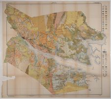
MAP.
Soil map, Beaufort County sheet, North Carolina.
SOIL SURVEY OF BEAUFORT COUNTY, NORTH CAROLINA.By W. B. COBB, In Charge, and E. S. VANATTA, of the United States Department of Agriculture. and L. L. BRINKLEY, S. F. DAVIDSON, and F. N. McDOWELL, of the North Carolina Department of Agriculture.—Area Inspected by W. EDWARD HEARN.
DESCRIPTION OF THE AREA.Beaufort County is in the eastern part of North Carolina. It is bounded on the north by Martin and Washington Counties, on the east by Hyde County, on the south by Pamlico and Craven Counties, and on the west by Pitt County. Washington, the county seat, is about 100 miles east of Raleigh and about 110 miles southwest of Norfolk, Va.
The county is very irregular in shape, the boundaries being formed in part by streams and embayments. Its length is approximately 40 miles from east to west, and its greatest width is about 33 miles. The land area of the county is 840 square miles, or 537,600 acres.
Beaufort County is located on the lower lying marine terraces of the Atlantic Coastal Plain, or in what is commonly known as the “flatwoods region.” It is divided in two parts by the Pamlico River, a wide tide-water stream or estuary with irregular shore lines.
Fig. 10.-Sketch map showing location of the Beaufort County area, North CarolinaThe surface of the county is low and generally level, with undulating or gently rolling areas near the streams in the western part. The surface geological formations1 are the Wicomico formation, which occurs in the southwestern part of Chocowinity Township and represents the most elevated part of the county; the Chowan formation, occurring at a slightly lower level and extending throughout the greater part of the western half of the county; and the Pamlico formation, occupying the eastern half of the county and the low-lying country along the Pamlico River and Tranters Creek.
The Wicomico and Chowan terrace areas consist of bodies of tableland, along the edges of which the tributaries of the larger streams have their source, with slightly undulating areas along these small streams and steeper slopes as the small tributaries converge, forming the branches and creeks that flow into the Pamlico River. In some
1 The Coastal Plain of North Carolina. By Wm. Bullock Clark, Benjamin L. Miller, L. W. Stephenson, B. L. Johnson, and Horatio N. Parker. North Carolina Geological and Economic Survey.places along the south side of the Pamlico River points of the upland terminate in low bluffs at the edge of the water, and the small streams have cut rather deep channels, forming comparatively steep valley slopes.
The larger level areas in the western part of the county occur as swamps, or pocosons, having a relatively high elevation. The most important of these are Great Swamp and Dismal Swamp, to the west and east of Pinetown in the north-central part of the county, and Big Pocoson, in the southern part of Chocowinity Township. The two former extend into Washington and Martin Counties, on the north, while Big Pocoson extends into Craven County, on the south.
The topography of the Pamlico terrace in the eastern part of the county is practically level. Along the rivers and some of the small streams there are some undulating areas, but in many places the surface is flat to the edge of the water. In a number of instances the streams are bordered by areas of tidal marsh or swamp but very little lower than the adjacent upland. In other instances, however, there are intermittent strips of higher, usually sandy soil between the level upland and the water.
The bottom lands of the county are represented by narrow swampy strips along the upper parts of the streams. These occur chiefly in the western half of the county.
The slope of the northern part of the county is in the same general direction as the course of the Pamlico River. The highest point in the county north of the Pamlico River is at Woolard Crossroads, in the northwestern part near the Martin County line, where the elevation is 61 feet above sea level. The slope from that point eastward is more gradual than westward toward Tranters Creek and southward to the Pamlico River. The elevation along Tranters Creek and at Washington is about 10 feet, while the elevation of the extreme eastern part of the county, in the vicinity of Belhaven and Leechville, varies from 2 or 3 to 5 feet above sea level. South of the river the slope is chiefly eastward, except in the extreme western part of the area, where it is northward toward the river. The range in elevation is approximately the same as on the north side of the river. The highest point, which occurs about 3 miles north of the Craven County line on the Vanceboro Road, is 67 feet above sea level, according to a United States Geological Survey bench mark.
The drainage of Beaufort County as a whole is poor. Near the streams, especially in the western part of the county, there are strips of well-drained land, but back a few hundred feet or sometimes a few feet from the stream the country is flat and the drainage poor. The drainage of the county is effected by the Pamlico River and its tributaries, the most important of which are the Pungo River, which forms a part of the eastern boundary of the county; Pantego and Pungo Creeks, tributaries of the Pungo River; North, Bath, Upper Goose, Broad, and Tranters Creeks,
which flow into Pamlico River from the north; and Goose Creek, which forms part of the east county boundary, and South, Durham, Blount, and Chocowinity Creeks, which enter the Pamlico from the south. The streams are comparatively short and sluggish. The rivers and lower parts of the creeks are broad and have channels sufficiently deep to accommodate boats of varying sizes. Tide water reaches as far west as Washington and well up into most of the creeks.
In general the county is so low and so nearly level that it is necessary for farmers to resort to artificial drainage. Small ditches are dug by hand on practically every farm, and in some sections, such as East Dismal, Pantego, and Jackson Swamps, important drainage districts have been established and large canals, to which smaller laterals are directed, have been dredged. Other such drainage districts are projected.
Beaufort County was formed from Bath County in 1741. The white population is largely of English and Scotch descent. In the 1910 census the total population is reported as 30,877, of which 70.6 per cent is classed as rural. The density of the rural population is given as 26 persons per square mile. About 42 per cent of the population consists of negroes.
Washington, the county seat, is located in the western part of the county. Its population is given in the 1910 census as 6,211. Belhaven, the next largest town in the county, is located on the Pantego River in the northeastern part of the county. Its population is reported as 2,863. The population of the other towns and shipping points ranges below 500. Aurora, Pinetown, Pantego, Bath, Leechville, Edward, Chocowinity, and Blount Creek are towns of local importance. Terra Ceia, a new town in the recently developed East Dismal Swamp drainage district, is an important point for the shipping of corn.
The transportation facilities of Beaufort County are good. The main line of the Norfolk Southern Railway passes through Washington, which is about midway between Raleigh and Norfolk. A branch line reaches south to Belhaven, and another connects Pinetown and Bishops Cross. Another branch of the Norfolk Southern connects Chocowinity with Newbern, in Craven County. The Atlantic Coast Line crosses the northwestern part of the county, and a branch of this railroad connects Washington with Vandemere in Pamlico County, traversing that part of Beaufort County south of the Pamlico River. Thus nearly every part of the county is within easy hauling distance of some railroad shipping point. In addition to the rail facilities, the county has good water transportation. Freight and passenger boats operate on the
Pamlico and Pungo Rivers, and a number of the towns are situated on navigable creeks.
The dirt roads of the county are good during the greater part of the year, but usually are in bad condition during the winter months. Considerable interest is being taken in road improvement. The grading and straightening of roads is in progress throughout the county, and in most townships cross roads and forks are well marked with sign posts.
Rural mail delivery reaches all parts of the county. Telephone service is in use in some sections. School facilities in the towns and in a number of the rural districts are good.
Norfolk is the principal outside market, handling most of the corn, potatoes, and live stock shipped from the county. The cotton crop is largely marketed in Wilmington and Norfolk. Tobacco is marketed at warehouses in Washington.
CLIMATE.The climate of Beaufort County is mild throughout the year. According to the records of the Weather Bureau station at Belhaven, in the northeastern part of the county, the mean annual temperature is 62° F. The winters are generally mild, the average temperature for December, January, and February being 45.3° F. There are usually three or four cold periods during the winter when the temperature falls as low as 15° or 20° F., and a temperature as low as 11° F. has been recorded in February. However, such low temperatures are unusual. Occasional light snows fall in the winter, but they are so slight as to be of little importance.
The summer months have an average temperature of 78.5° F. Since the Weather Bureau station was established at Belhaven a maximum temperature of 102° F. has been reached, in July.
The growing season in Beaufort County is comparatively long. The average date of the last killing frost in the spring is April 1, and that of the first in the fall October 31, making the average growing season approximately seven months in length. Frosts have been recorded as late in the spring as April 26, and as early in the fall as October 11.
The average annual rainfall is 47.98 inches. The total precipitation for the driest year on record (1911) was 32.49 inches, and for the wettest year (1910), 74.74 inches. The greater part of the rain comes during the summer months, the average for June, July, and August being 19 inches. The rainfall for the rest of the year is rather evenly distributed. The winter rains are lighter and occur more frequently than the summer rains. In the spring and summer there are, occasionally, short periods of drought in which crops suffer. These periods are sometimes followed by excessive rains
which do considerable damage to crops grown under imperfect drainage conditions.
Occasional hail storms visit the county, but they are usually confined to small areas, and the damage to crops from this source is comparatively slight.
The following table gives the normal and extreme monthly, seasonal, and annual temperature and precipitation as recorded at Belhaven:
| Month. | Temperature. | Precipitation. | ||||
| Mean. | Absolute maximum. | Absolute minimum. | Mean. | Total amount for the driest year (1911). | Total amount for the wettest year (1910). | |
| ° F. | ° F. | ° F. | Inches. | Inches. | Inches. | |
| December | 44.0 | 76 | 14 | 3.17 | 2.85 | 3.40 |
| January | 45.8 | 80 | 16 | 3.76 | 2.65 | 1.94 |
| February | 46.0 | 78 | 11 | 3.33 | 1.15 | 4.79 |
| Winter | 45.3 | 80 | 11 | 10.26 | 6.65 | 10.13 |
| March | 50.1 | 91 | 19 | 3.48 | 4.33 | 1.66 |
| April | 61.6 | 94 | 27 | 2.97 | 2.71 | 2.84 |
| May | 70.3 | 96 | 36 | 4.03 | 1.35 | 9.81 |
| Spring | 60.7 | 96 | 19 | 10.48 | 8.39 | 14.31 |
| June | 70.8 | 100 | 50 | 6.24 | 2.52 | 10.91 |
| July | 79.6 | 102 | 53 | 5.58 | 3.15 | 11.11 |
| August | 79.0 | 96 | 55 | 7.18 | 1.88 | 17.67 |
| Summer | 78.5 | 102 | 50 | 19.00 | 7.55 | 39.69 |
| September | 73.7 | 101 | 41 | 4.21 | 4.26 | 5.98 |
| October | 64.4 | 90 | 27 | 2.43 | 3.74 | 4.15 |
| November | 52.4 | 83 | 22 | 1.60 | 1.90 | .48 |
| Fall | 63.5 | 101 | 22 | 8.24 | 9.90 | 10.61 |
| Year | 62.0 | 102 | 11 | 47.98 | 32.49 | 74.74 |
Beaufort County was settled about 200 years ago, at which time the agriculture consisted chiefly in the growing of corn, wheat, and oats and the raising of live stock, principally for home consumption. Subsequently cotton was introduced and became one of the most important crops. In 1879, according to the 1880 census, corn was the leading crop in the county in point of acreage, being grown on somewhat more than 20,000 acres. Cotton was second in area, with about 12,000 acres. Sweet potatoes were grown on about 1,700 acres, oats on about 1,400, rice on about 1,000, and wheat on less
than 400 acres. In the 1890 census corn is reported on about the same acreage, while the acreage devoted to cotton had increased to about 16,000 acres, the oat acreage had nearly doubled, and the growing of sweet potatoes and rice had increased. The acreage devoted to wheat had been reduced considerably.
By 1900 the corn acreage had increased to about 26,000 acres, while the cotton acreage had declined. The acreage in oats was slightly decreased, the crop being reported on about 2,000 acres. Rice occupied about the same acreage as in 1889, while the acreage in sweet potatoes increased somewhat. Tobacco, Irish potatoes, cowpeas, and peanuts had become important crops, and hay and forage crops occupied a combined area of nearly 2,000 acres. In the 1900 census the value of live stock and live-stock products is given as $188,684.
In the 1910 census corn is reported on about 26,000 acres, with a yield of 531,000 bushels, and cotton on 15,000 acres, with a production of 9,000 bales. Hay and forage crops occupied a total of approximately 4,500 acres, 3,900 acres of which were devoted to grains cut green. Somewhat less than 1,000 acres were in oats, about 1,100 acres in peanuts, and 1,800 acres in cowpeas. Sweet potatoes are reported on about 2,800 acres, and Irish potatoes on 1,200 acres. About 1,700 acres were in tobacco. A total of 16,700 apple trees and 15,500 peach trees is reported, and nearly 3,000 grape vines. The same report states the number of farm animals sold or slaughtered as 106 calves, 1,856 other cattle, 18,492 hogs, and 501 sheep. There were in this year 2,432 dairy cows on farms. The following table gives the value of farm products of the county as given in the 1910 census:
| Cereals | $405,628 |
| Other grains and seeds | 46,861 |
| Hay and forage | 70,141 |
| Vegetables | 239,289 |
| Fruits and nuts | 25,118 |
| All other crops (chiefly cotton and tobacco) | 1,050,075 |
| Live stock and products: | |
| Animals sold or slaughtered | 202,638 |
| Dairy products, excluding home use | 21,295 |
| Poultry and eggs | 87,412 |
| Wool, mohair, and goat hair | 531 |
| Total value | 2,148,988 |
Since the last census was taken Beaufort County has undergone considerable agricultural development. New land has been opened up and the acreage of a number of crops has been considerably increased. About 35,000 acres are now devoted to corn.1 The cotton acreage probably is less than it was in 1910, while Irish potatoes have
1 Estimates of the acreage of different crops were obtained from the county agent, Mr. J. F. Latham.become one of the important cash crops, the estimated present acreage being 4,500. Soy beans have been grown in the county in a small way for about 30 years, but not extensively until recently. They now practically have taken the place of cowpeas and occupy an estimated acreage of about 8,000 or 9,000 acres. The area in tobacco has been increased to about 3,500 acres and the growing of sweet potatoes and peanuts is steadily increasing.
The agriculture of Beaufort County consists mainly of general farming, although in the vicinity of Terra Ceia, and in other parts of the county on swampy soils there are many farms devoted almost exclusively to the production of corn, while many of the farmers in the county, especially in the vicinity of Aurora, make a specialty of potatoes. The main cash crops are cotton, tobacco, corn, soy beans, potatoes, and sweet potatoes. Corn and soy beans are also used as feed crops for the work stock and other farm animals. The principal other crops used for this purpose are peanuts, oats, part cut for hay, clover, and orchard grass. About 140 acres of wheat were planted in the county in the fall of 1916, and a number of the farmers are planning to grow wheat in the fall of 1917. Wheat should become a more important crop. A modern flour mill is located at Washington.
More or less corn is grown on every farm. The majority of the farmers grow it for home use, but a number produce it for outside markets. Soy beans are grown principally for seed, which is sold to farmers throughout the State of North Carolina and to a small extent in adjacent States. Some of the crop is shipped to a mill in Elizabeth City, where it is made into oil and bean meal. That part of the crop not sold or saved for seed is fed to live stock on the farm. A part of the crop is cut for hay. Soy beans and cowpeas frequently are planted together for this purpose.
Most of the potatoes and sweet potatoes produced in the county are sold to buyers from Norfolk. A part of the crop is consumed on the farm or sold at local markets. The cotton produced in the county goes principally to Norfolk, although some of it is sold in Wilmington. Tobacco is disposed of at the local markets in Washington. A part of the peanut crop is shipped out of the county, and a part is used for hog pasture, the hogs being fattened on the peanuts and finished on corn.
The oat crop is used chiefly for feeding work stock on the farms, the greater part of it being cut green for hay. The other hay crops consist principally of redtop, orchard grass, red clover, and alsike clover. These, however, are not grown very extensively, and the entire production is consumed on the farms of the county. Some Sudan grass is grown. The growing of winter cover crops is increasing.
English peas, onions, radishes, string beans, lima beans, cabbage, collards, watermelons, and cantaloupes are grown on nearly every farm for home use, and sometimes for local markets. Tomatoes, strawberries, and cucumbers also are grown. Home demonstration work is actively carried on in the county, and members of the girls' clubs can vegetables and fruits for use at home and for sale.
Very few horses and mules are produced for market. Cattle are well distributed over the county, being most numerous near the swamps and large uncultivated areas. They are fed to some extent in the winter, but subsist mainly by grazing. There is no stock law over most of the county, the cattle being allowed to graze on the open range. Cattle that are marketed are grazed throughout the spring and summer and sold to buyers from Norfolk and Richmond in the fall. A number of the farmers feed small quantities of grain shortly before the cattle are sold. Dairying is practiced to a limited extent, and only to supply local markets.
Hogs are generally grazed the greater part of the year, but are finished on peanuts, cowpeas, soy beans, and grain before being sold to buyers in the fall and winter. Large numbers are shipped to Norfolk, while others are slaughtered for home consumption and the local markets. Hogs are most extensively raised along the Pungo River northeast of Belhaven, although they are well scattered over the county.
Sheep and goats are raised for wool and hair, and are slaughtered for home use and for sale at the local markets. They are largely confined to the central part of the county north of the Pamlico River. Poultry is raised on every farm and generally constitutes an important source of the farm income.
The topography and soil, to a small extent, influence the character of the crops grown. Potatoes usually are grown on light-textured soils, which are naturally or artificially well drained, the Bladen types being considered the best soils for this crop. Tobacco gives best results when grown on well-drained soils, and is generally found on types of the Norfolk, Dunbar, and Ruston series. Low-lying, dark-colored soils, rich in organic matter, such as the Portsmouth, Hyde, and Bladen soils and Muck are considered best for corn.
The better farmers in the county use two-horse plows and riding cultivators and thoroughly prepare the seed bed before planting. The operators of smaller farms use one-horse implements. Tractors have been used only experimentally. About 10 per cent of the land is plowed in the fall. Swamp land is generally prepared for cultivation by cutting and burning the timber. Corn is the first crop planted on such new land, the seeds being planted in a hole made in the unplowed land by means of a sharpened stake. It is not cultivated the first year. As the land gradually becomes cleared by
subsequent burnings and the rotting of logs and stumps, the “sticking” of corn is abandoned and cultivation is resorted to.
The equipment of the different farms varies considerably. Most of the farm houses are good-sized, comfortable buildings. There are a number of very attractive farm houses in the county. Owing to the mildness of the winters the barns are not so carefully constructed as the houses. Nearly every farm is well stocked with modern farm implements, including planters and cultivators. The work stock is generally of medium weight. The cattle and hogs are mainly grades. Some attention is being given to improving the live stock on the farms. By passing a stock law and establishing a larger number of dipping vats the outlook for the cattle industry probably would be greatly improved.
No definite crop rotation is practiced by the farmers of the county. On some farms corn is rotated with cotton, cowpeas or soy beans being planted in the corn. Occasionally tobacco follows corn and frequently sweet potatoes follow Irish potatoes.
The 1910 census reports a total expenditure of $139,754 for fertilizer, 1,828 farms reporting its use. At that time complete fertilizers were used on most of the crops, but recently very little potash has been available. On some of the more productive soils little commercial fertilizer is used until the land has been cropped several years. The general practice is to fertilize according to the crop and not according to the soil. The principal fertilizers used in the county at present are acid phosphate and cottonseed meal. Nitrate of soda is used on cotton. For corn from 300 to 500 pounds of acid phosphate and half as much cottonseed meal per acre is used on the lighter colored soils, while the mixture for the darker soils contains less of the meal. Cotton receives very much the same treatment, with sometimes an addition of fish scrap. Nitrate of soda is sometimes substituted for the cottonseed meal. The mixture applied to cotton usually will analyze about 4-6-1.1 Soy beans are generally fertilized with 300 to 500 pounds of acid phosphate, except where the crop is planted in corn when no fertilizer is used. Where the land seems inclined to be acid it is limed.
Tobacco land generally receives an application of about 1,000 pounds of fertilizer per acre. An 8-3-3 mixture was extensively used. Recently wood ashes have largely been used to supply potash. Potatoes receive from 1,000 to 2,000 pounds of a 5-8-0 mixture. When potash was available a 5-7-8 fertilizer was considered best for this crop.
A large part of the farm labor is performed by the farmer and his family. Farm laborers are drawn from both white and negro races, and are generally paid 75 cents to $1 a day. The higher rate is
1 Per cent of nitrogen, phosphoric acid, and potash, respectively.without board. For planting and harvesting corn in newly opened drainage districts laborers receive from $1.50 to $2.50 a day. The greater part of this work is performed by negro labor, and both men and women are employed. Laborers hired for long periods are paid from $15 to $20 a month with board. In the 1910 census 1,448 farms report the employment of labor, with a total expenditure of $231,522.
The farms vary in size from 20 or 30 acres to 1,000 acres or more. The average size is about 85 acres.1 The 1910 census reports a total of 2,951 farms in the county, comprising 46.3 per cent of the total land area. Of the land in farms 28.3 per cent, or about 24 acres per farm, is reported improved.
About 70 per cent of the farms are operated by the owners and practically all the remainder by tenants. The ratio between farms operated by owners and by tenants has changed very little during the last 40 or 50 years. Very little land is rented for cash. There are two prevailing systems of share renting. Under one system the land owner furnishes the land, the seed, work stock, and implements and receives one-half the crop; under the other the tenant furnishes everything but the land, and the owner receives one-third the crop.
The range in the selling price of land varies from $20 an acre for unimproved, forested land to about $250 an acre for well-located, improved farm land especially adapted to corn and potatoes. The prevailing price for average farm land is about $50 an acre. The average assessed value is given in the census of 1910 as $15.91 an acre.
SOILS.Beaufort County lies within the Coastal Plain soil province, and the soils are derived from unconsolidated sands and clays of sedimentary origin composed of materials brought down from the Piedmont Plateau and Appalachian Mountain regions and deposited on the sea floor in ancient times. These sediments since their elevation above water have been more or less modified by drainage, oxidation, erosion, the decay of plants, and, in isolated instances, by wind action. The percolating rain water has carried much of the finer material down from the surface, and this, together with the action of streams and erosion, has resulted in the subsoils having a generally heavier texture than the surface soils. The red and yellow colors in many of the soils are due largely to the oxidation of the iron-bearing minerals contained in the soil. The dark-gray and black colors are the result of the decay of varying quantities of organic matter. The mottling in some of the subsoils is due largely to imperfect drainage conditions, the subsoil being saturated at such frequent intervals
1 The census tabulates each tenancy as a farm.that the iron-bearing minerals in the soil have been only partly oxidized. The elevation and drainage in different parts of the county have caused considerable difference in the soils.
All of these factors acting upon the original material have produced a number of different soils and varied soil conditions. The soils are grouped broadly into soil series, the soils of each series being similar in origin, color of the surface soil, color and structure of the subsoil, and in topography and drainage. The soil series is divided into soil types on the basis of texture. Seven soil series including 15 soil types are recognized in Beaufort County. In addition to these normal soils three miscellaneous types, Muck, Swamp, and Tidal marsh, are mapped.
The surface soils of the Norfolk series are prevailingly gray. Directly below the surface there is a lighter gray or yellowish-gray layer which passes into a yellow friable sandy clay or sand. These soils occupy undulating to slightly rolling uplands throughout the Atlantic and Gulf Coastal Plain. The series is represented in Beaufort County by three types, the fine sand, fine sandy loam, and very fine sandy loam.
The Ruston types have a grayish or brownish surface soil, and a yellowish-red, reddish-yellow, or dull-red, friable sandy clay subsoil. Occasionally the lower part of the subsoil is mottled slightly with gray or yellow. The subsoil is generally less friable in structure than the subsoil of the Norfolk series. One member of this series, the Ruston sandy loam, is mapped in Beaufort County.
The Dunbar series is characterized by a gray surface soil, passing into a yellow, compact upper subsoil which below a depth of 15 to 20 inches is mottled with red and gray. The series is intermediate in position between the Norfolk and the Coxville series, being slightly less well drained than the former and better drained than the latter. The Dunbar very fine sandy loam is mapped.
The Coxville series comprises dark-gray to nearly black soils, with subsoils ranging from mottled yellow and gray clay, tough or moderately friable in the upper part to plastic, compact clay of a mottled drab or gray, red, and yellow color in the lower part. The topography is prevailingly flat, with frequent sparsely timbered areas. Two types, the very fine sandy loam and silt loam, are mapped in Beaufort County.
The soils of the Bladen series are characterized by gray or brownish to nearly black surface soils. The subsoils consist of mottled brown, yellow, and drab or bluish-gray, heavy, plastic clay. The series evidently is intermediate between Tidal marsh and the Coxville soils. It differs from the latter in not being so well drained and in the absence of red in the subsoil. Artificial drainage is necessary
in most areas before the Bladen soils can be utilized for agriculture. Four types, the fine sandy loam, very fine sandy loam, loam, and silt loam, are mapped in this county.
The surface soils of the types included in the Portsmouth series are dark gray to black, and high in organic matter. The subsoils are light gray to mottled gray and yellow, and in the heavier types are always plastic, though usually carrying a noticeable quantity of sand. These soils occur in flat to slightly depressed, poorly drained situations, and require ditching before they can be used for agriculture. The series is developed in the flatwoods or the low, seaward portion of the Coastal Plain. Scattered areas also are found in the poorly drained depressions of the higher Coastal Plain country. The Portsmouth series is represented in Beaufort County by the fine sand, fine sandy loam, and loam types.
The surface soil of the Hyde series is characterized by its black color and high organic-matter content. Typically the soil is black and uniform to a depth of 3 feet or more, but in places it grades into a gray sandy clay. The Hyde series is developed in flat or slightly depressed, poorly drained areas and usually is forested with a heavy growth of hardwood. The soil is very productive, but artificial drainage is necessary before it can be used for crop production. The Hyde loam is mapped in this county.
Large areas of Muck and smaller areas of Swamp and Tidal marsh are mapped. Muck consists of dark-brown or black, well-rotted vegetable matter containing varying quantities of mineral material. It occurs in swampy areas. The areas mapped as Swamp are lowlying, wet or swampy areas composed of miscellaneous material, principally Muck or Peat, generally mixed with varying quantities of soil material washed from near-by slopes. Areas mapped as Swamp in Beaufort County are of little value for agriculture, but usually support a growth of merchantable timber. Tidal marsh consists of flat, grassy areas bordering streams, subject to inundation by tides. The surface material is generally Peat, and the underlying material clay.
Some marl occurs in the county in the vicinity of Terra Ceia and near Blount Pocoson and Gum Swamp. It occurs at depths varying from 3 to 6 feet or more, and does not materially influence the soil. It is dug and used on acid soils to a small extent.
The following table gives the name and actual and relative extent of the several soil types mapped:
| Soil. | Acres. | Per cent. | Soil. | Acres. | Per cent. |
| Dunbar very fine sandy loam | 58,304 | 10.8 | Portsmouth fine sand | 26,496 | 4.9 |
| Portsmouth loam | 49,216 | 9.7 | Norfolk fine sand | 21,696 | 4.0 |
| Savanna phase | 2,624 | Norfolk fine sandy loam | 13,056 | 3.6 | |
| Bladen loam | 49,344 | 9.2 | Deep phase | 4,096 | |
| Portsmouth fine sandy loam | 37,312 | 8.7 | Flat phase | 2,240 | |
| Swamp phase | 9,408 | Bladen silt loam | 15,360 | 2.9 | |
| Coxville very fine sandy loam | 41,152 | 7.7 | Hyde loam | 15,104 | 2.8 |
| Coxville silt loam | 39,232 | 7.3 | Bladen fine sandy loam | 12,352 | 2.3 |
| Muck | 35,648 | 7.0 | Tidal marsh | 8,960 | 1.7 |
| Shallow phase | 1,984 | Ruston sandy loam | 2,048 | .4 | |
| Bladen very fine sandy loam | 32,448 | 6.0 | |||
| Norfolk very fine sandy loam | 30,848 | 5.7 | Total | 537,600 | |
| Swamp | 28,672 | 5.3 |
The surface soil of the Norfolk fine sand is a gray or light-gray fine sand, 4 to 6 inches deep. The subsoil is a yellow or pale-yellow, rather loose fine sand which is generally uniform in color and structure to a depth of 3 feet or more, but frequently is pale yellowish gray below about 30 inches. Occasionally on the tops of knolls the surface soil is almost white, while in more heavily wooded, nearly level areas a larger content of vegetable matter gives the surface soil a dark-gray color. Northwest of Washington along the Atlantic Coast Line Railroad a few comparatively small areas of Norfolk sand are included with the Norfolk fine sand, and about 2 miles southwest of Core Point there is a small area which has a light-gray or white subsoil. These variations from the typical Norfolk fine sand are not mapped separately because they are of small extent and differ very little in agricultural value from the main type.
This type occurs most extensively along the north side of the Pamlico River and one of its tributaries, Tranters Creek, occupying a more or less continuous strip from about 2 miles south of the Martin County line on Tranters Creek to Pamlico Beach, near where the Pungo River joins the Pamlico. Probably the largest single area lies at Edward, on both sides of Durham Creek, but mainly on the east side along the Old Sandhill Road. Smaller areas and strips are mapped along the Vanceboro Road, along the road running north from Acre to the Washington County line, and around Pantego Swamp.
The Norfolk fine sand occurs as undulating to slightly rolling sand hills and low ridges. It is well drained and in some cases excessively drained. The water-holding capacity of the soil depends largely
upon the amount of organic matter present. In the vicinity of Washington about 60 per cent of the type is in cultivation, while only about 20 per cent of the outlying areas are tilled. Uncultivated areas are forested chiefly with second-growth pine and small red, post, and blackjack oak. Sourwood and dogwood are sometimes found on the type. A heavy growth of wire grass covers the area near Edward.
Trucking is the most important type of agriculture, potatoes, sweet potatoes, watermelons, cantaloupes, and beans being the leading crops. The production of peanuts is developed to some extent. Some general farming is carried on, but corn and cotton yields usually are very low, although where large quantities of vegetable matter have been added to the soil and proper fertilization is practiced, the yields of these crops are high enough to make their production profitable. Ordinarily corn yields from 10 to 20 bushels per acre, and cotton from one-fourth to one-half bale. Some tobacco is grown, but with less success than on the Norfolk fine sandy loam and very fine sandy loam. Cattle are grazed on the uncultivated areas, but the grass is rather sparse and the live-stock industry is not extensively developed.
Only the lightest farming implements are used in the cultivation of this soil. The fertilizers used on the Norfolk fine sandy loam and very fine sandy loam are applied.
The land sells for $10 to $50 an acre, according to location and improvements, the higher priced land being in the vicinity of Washington, which affords a ready market for truck crops.
Improvement of the Norfolk fine sand can best be brought about by the growing and turning under of green-manure crops, which will increase the power of the soil to hold moisture and also make the application of commercial fertilizers more efficacious.
NORFOLK FINE SANDY LOAM.The surface soil of the Norfolk fine sandy loam is a gray loamy fine sand or fine sandy loam, 4 to 6 inches deep, underlain by a yellow or pale grayish yellow loamy fine sand which continues to a depth of 12 to 18 inches, where it grades into a yellow, friable fine sandy clay. This typically continues to a depth of 3 feet or more without change, although in some instances below a depth of about 30 inches the subsoil is yellow, mottled slightly with yellowish red or gray. The soil of forested areas is darker than in fields that have been cultivated for some time.
In a few small areas, occurring generally as inclusions in larger typical areas, that part of the soil immediately below the surface few inches is brown, the subsoil being typical. Frequently along the steeper slopes the subsoil is slightly reddish in color, but not red enough to
warrant classifying the areas with the Ruston soils. In other places along the boundaries between the Norfolk fine sandy loam and soils of the Dunbar and Coxville series the subsoil is heavier and more compact in structure than typical, and frequently it is slightly mottled with gray in the lower part.
The type occurs as comparatively high land principally in the western end of the county, as better drained areas and strips along the Pamlico River front, and to a small extent along the Pungo River and the larger creeks in the eastern part of the county. It generally forms well-drained areas adjacent to streams, and is undulating to gently rolling in topography with occasional nearly level areas and some slight depressions. The drainage is good but not excessive.
Although the total area of the Norfolk fine sandy loam in Beaufort County is comparatively small, it is one of the most important agricultural soils. Probably 75 per cent of it is in cultivation. Uncultivated areas are generally forested with pine, oak, dogwood, and some sweet gum. Some longleaf pine occurs on the type, although most of the forest of this kind has been cut.
The crops most extensively grown on the Norfolk fine sandy loam are tobacco, cotton, and corn, while sweet potatoes, soy beans, cantaloupes, cucumbers and other vegetables are important. Peanuts do well on the type, and peach trees are found on nearly every farm. Some cattle and hogs are raised, but the live-stock industry is not important. Tobacco probably is the most important crop. It yields from 700 to 1,500 pounds per acre. Cotton yields from one-half to 1 bale per acre, corn from 15 to 40 bushels, potatoes from 50 to 75 barrels, sweet potatoes about 150 bushels, soy beans from 15 to 40 bushels, and peanuts about 30 to 60 bushels per acre.
The Norfolk fine sandy loam is easily handled. It is generally broken in the spring with 1-horse, sometimes with 2-horse, turning plows, and cultivated after the crop is up with 1-horse implements. The quantity of fertilizer used considerably influences the yields of the different crops. The most heavily fertilized crops are potatoes and tobacco. Irish potatoes in the year the survey was made (1917) were generally receiving from 1,600 to 2,000 pounds per acre of a 5-8-0 mixture. When potash was available the popular formula was 5-7-8. Tobacco receives about 1,000 pounds of an 8-3-3 mixture. In many cases wood ashes are being used as the potash carrier. Corn generally yields best where fertilized with 300 to 400 pounds of acid phosphate and about 200 pounds of cottonseed meal. Cotton is generally fertilized with 400 to 800 pounds of a mixture that averages about 4-6-1 and generally contains fish scrap and nitrate of soda. Lime is generally applied to the soil for soy beans, peanuts, and other leguminous crops. The rate of application usually is 2 tons per acre every two or four years. The selling price of the Norfolk fine sandy
loam ranges from $25 an acre for forested land to $125 for well-located, improved land.
Experiments and analyses at the Edgecombe Test Farm by the North Carolina Department of Agriculture indicate that on the average a mixture containing about 7 per cent of available phosphoric acid, 7 per cent of nitrogen, and 5 per cent of potash, applied at the rate of 400 to 1,000 pounds per acre, is most effective for this type of soil, and best results were obtained where one-half the fertilizer was applied in the drill at the time of planting and the other half distributed along the row about the 1st of July.
Norfolk fine sandy loam, deep phase.—The deep phase of the Norfolk fine sandy loam consists of a gray loamy fine sand, underlain at a depth of about 6 inches by a pale-yellow loamy fine sand which continues to 18 to 30 inches without appreciable change. This is underlain by a yellow, friable fine sandy clay to 3 feet or more. This phase of the Norfolk fine sandy loam differs from the typical principally in the depth at which the yellow fine sandy clay subsoil is encountered, but the surface soil is likely to be somewhat lighter in texture, as in the areas south of Core Point where it varies from a loamy fine sand to a fine sand.
Areas of this phase occur principally north and west of Bonnerton, south of Core Point, and in a few localities back from Tranters Creek, northwest of Washington. A few other small areas are encountered in different parts of the county. The topography of the phase is similar to that of the main type, as are the drainage conditions. The phase is handled and fertilized in the same manner as the main type and about the same crops are grown. The yields are slightly below the average for the typical Norfolk fine sandy loam.
The deep phase has a somewhat lower selling price than the main type. It seems to be in need of vegetable matter, and the more extensive growing and plowing under of leguminous cover crops should prove beneficial.
Norfolk fine sandy loam, flat phase.—The surface soil of the flat phase of the Norfolk fine sandy loam is a gray or light-gray fine sandy loam from 4 to 6 inches deep, underlain by a pale-yellow fine sandy loam. This in turn is underlain at a depth of 10 to 15 inches by a subsoil of yellow fine sandy clay less friable than the subsoil of the typical Norfolk fine sandy loam and also differing from it in being slightly mottled with gray below 24 or 30 inches. The surface of the areas is practically level, except in very narrow strips along drainage ways, and the natural drainage is poor. The greater part of the phase, however, has been made suitable for farming by means of open ditches.
Cotton and corn are the crops most extensively grown, while soy beans and, in better drained places, tobacco are important. Owing
to its advantageous location near the town of Bath, the selling price of this land averages almost as high as that of the typical Norfolk fine sandy loam.
NORFOLK VERY FINE SANDY LOAM.The surface soil of the Norfolk very fine sandy loam varies from a light-gray very fine sandy loam in areas that have been cultivated for a number of years to a fairly dark gray very fine sandy loam in forested areas. It usually is 5 or 6 inches deep, and is underlain by a layer of pale-yellow very fine sandy loam which extends to a depth of 8 to 14 inches. Below this the subsoil is moderately friable very fine sandy clay to fairly compact but friable clay or clay loam, frequently slightly mottled with yellowish red or gray below 30 inches, though typically yellow to a depth of 3 feet or more. The heavier structure and the mottling occur mainly where the type is closely associated with the soils of the Dunbar and Coxville series.
The Norfolk very fine sandy loam is well distributed over the western end of the county and is found in small areas as far east as Hunters Bridge and Blount Creek. The type occurs as undulating to gently rolling areas in the vicinity of streams, and except in occasional small depressions has good natural drainage.
There are about 48 square miles of this type in the county, probably 70 per cent of which is under cultivation. The uncultivated areas are forested with oak, pine, dogwood, and sourwood.
The Norfolk very fine sandy loam is handled and fertilized in the same way as the Norfolk fine sandy loam, and about the same crops are grown. The very fine sandy loam, however, does not mature crops quite as early as the fine sandy loam, and is not used as extensively for potatoes and early vegetables. On the other hand, small-grain crops do better on the very fine sandy loam than on the fine sandy loam, and oats are much more extensively grown than on the former type. The yields on the two types, however, do not differ widely.
Areas of this type bring from $25 an acre for unimproved forested land to $100 an acre for land in a high state of cultivation.
The fertilizer needs of this type probably are about the same as those of the Norfolk fine sandy loam.
Ruston SANDY LOAM.The surface soil of the Ruston sandy loam is a brown, brownishgray, or gray sandy loam or fine sandy loam, varying in depth from 10 to 18 inches. The subsoil is a yellowish-red, yellowish-brown, or dull-red, fairly friable sandy clay to fine sandy clay, which in places is mottled slightly with yellow below 30 inches, but more typically is dull red or brownish in color to a depth of 3 feet or more. In the
area of the type northwest of Washington small patches occur in which the surface soil is a lighter grayish brown than the rest of the type and is a loamy sand rather than a sandy loam in texture. The subsoil in these patches is generally encountered at 18 to 24 inches instead of at shallower depths, as is more typical. In the vicinity of Bunyan the surface soil is finer textured than in the other areas mapped.
The type occurs on ridges and well-drained elevations, or forms slopes adjacent to streams, and has an undulating or gently rolling topography. It is mapped most extensively northwest of Washington near Tranters Creek and on the long, sandy ridge which divides the swamp between Washington and Chocowinity in two parts. Small scattered areas lie east of Washington and in the vicinity of Hunters Bridge. The type is inextensive, but the greater part of it is cultivated.
The important crops are cotton, corn, tobacco, and truck crops. The yields generally are somewhat lower than on the Norfolk fine sandy loam. Crops are handled and fertilized in the same manner as on that soil.
Being for the most part advantageously situated, the value of this land is comparatively high, prices ranging from $30 to $90 an acre.
Dunbar VERY FINE SANDY LOAM.The surface soil of the Dunbar very fine sandy loam is a very fine sandy loam which ranges in color from gray or light gray where it has been cultivated for some time to dark gray where it is still in forest. These conditions also influence the depth to some extent, the layer in forested areas being 3 or sometimes 4 inches thick, while in cultivated areas the depth is largely determined by the depth of plowing, being generally 4 to 6 inches. Below this surface layer there lies a light-yellow very fine sandy loam which extends to a depth of 12 to 18 inches. The underlying subsoil usually is a bright-yellow, tough or rather plastic clay, usually mottled with red and gray in the lower part. In some places the subsoil below 30 inches is a plastic fine sandy clay instead of a clay in texture. Frequently where the type is closely associated with the Coxville soils the entire subsoil is a mottled heavy clay, the gray mottlings being more pronounced than in typical areas. Some variations occur also in the surface soil. In the vicinity of Hills Creek and Joe Branch the surface soil approaches very closely a silt loam, and just south of Chocowinity and to the north of Latham there are small areas of fine sandy loam, which are included with the very fine sandy loam because they are too small to be separated satisfactorily on the soil map. Such areas have practically the same value as the typical soil.
The Dunbar very fine sandy loam occurs throughout the county and is one of the more extensive types mapped. It is intermediate in many characteristics, and especially in topography and drainage, between the Norfolk and Coxville soils.
The type is generally level to undulating. It is sometimes slightly rolling where it occurs near streams, and is often nearly level back from the streams and where it borders on the more poorly drained Coxville soils. Owing to the tenacious nature of the subsoil the underdrainage is poor; the surface drainage is fairly good.
About 20 per cent of this type is cultivated. Uncultivated areas are forested with small oak, second-growth pine, dogwood, sweet gum, sourwood, some hickory, and holly. The most important crops on the type are cotton, corn, and tobacco. Soy beans, cowpeas, oats, and vegetables are grown to some extent, and a number of farmers grow crimson clover as a winter cover crop. Some peanuts and potatoes are grown. Cotton produces from one-third to 1 bale per acre, corn from 15 to 40 bushels, tobacco from 600 to 1,200 pounds, and soy beans from 15 to 30 bushels. Oats are generally cut green for hay, but where grown for seed they produce from 15 to 40 bushels per acre. The oat crop is not fertilized; it generally follows a fertilized crop. The soil occasionally is plowed in the fall, but the general practice is to break the land in the spring shortly before the time of seeding. The different crops on the Dunbar soil are fertilized in about the same manner as the same crops on the Norfolk soils.
The Dunbar very fine sandy loam generally sells for $25 to $75 an acre, depending on location and improvements.
The compact character of the subsoil and the comparatively fine texture of the surface soil make the Dunbar very fine sandy loam a later soil than the looser structured, lighter textured Norfolk and Ruston soils. On this account, especially where the surface soil is shallow, fall and winter plowing and the growing and plowing under of winter cover crops are good practices. The use of lime, especially on the more nearly level areas of the type, also is beneficial.
Coxville VERY FINE SANDY LOAM.The Coxville very fine sandy loam has a dark-gray to gray very fine sandy loam surface soil, from 6 to 8 inches deep. This passes into a mottled yellow and gray, rather heavy very fine sandy clay or silty clay, which in turn grades at 12 to 15 inches into a mottled yellow and gray, plastic, tenacious clay, which is generally more or less mottled with red below 24 to 30 inches. Where the type has been cultivated for a number of years, the surface soil frequently is rather light gray in color, while in forested areas the material to a depth of 2 to 4 inches is very dark gray or nearly black. In the vicinity of Everett School
and near Surry small areas of the Coxville fine sandy loam are included with the type.
The Coxville very fine sandy loam is one of the more extensive types in the county, being well distributed over the western part. It occurs chiefly as flat, imperfectly drained, or poorly drained areas. It seldom borders drainage ways, generally being separated from the streams by strips of Dunbar or Norfolk soil. Both the surface drainage and underdrainage are deficient. The impervious character of the subsoil prevents the free downward movement of water, and in periods of excessive rainfall the soil frequently becomes waterlogged. The type gives an acid reaction with litmus paper. Artificial drainage is an essential factor in the preparation of land of this type for the growing of crops.
The Coxville very fine sandy loam is a relatively unimportant soil type agriculturally. Only a very small percentage of it is cultivated, and the cultivated areas usually occur as parts of fields which are largely on better drained types of soil. Some cattle and a few hogs and goats are grazed on the uncultivated areas, which are forested mainly with pine and in some areas with sweet gum and black gum. There is an undergrowth of gallberry bushes. Broom sedge is a characteristic growth in thinly forested areas and in old fields.
The principal crops on this type are corn and cotton. Corn yields from 15 to 40 bushels per acre and cotton from one-third to three-fourths bale. The same fertilizers are used for these crops as on the Norfolk soils.
Land of this type sells for $25 to $40 an acre. The value of uncultivated land is generally determined by the amount and quality of the standing timber.
More of this soil could be profitably farmed if it were properly drained. Fairly heavy applications of lime are beneficial, and the growing and plowing under of winter cover crops increase its productiveness.
Coxville SILT LOAM.The surface soil of the Coxville silt loam in forested areas is an almost black silt loam to a depth of 3 to 4 inches, underlain by a gray or yellowish-gray silt loam to a depth of 6 to 8 inches. In cultivated areas the immediate surface soil is much lighter in color than in forested areas, being gray and in some cases light gray. The subsoil is a mottled yellow and gray silty clay which becomes heavier and more plastic with increase in depth. Below a depth of 24 to 30 inches the material is a mottled yellow, gray, and red plastic clay, which continues to a depth of 3 feet or more.
The Coxville silt loam occurs rather extensively throughout the western half of the county, and a few small areas are mapped east of Aurora. The type occupies nearly flat and level areas in which
drainage channels have only partially been developed. Where it occurs near small streams the topography frequently is slightly undulating, although the slopes to the streams occasionally are very gradual. Both the surface drainage and underdrainage are poor, and it is necessary to provide artificial drainage in preparing the land for cultivation.
This type is not extensively cultivated, being utilized chiefly for grazing and lumbering. Probably 95 per cent of the type is in forest, consisting of loblolly pine, sweet gum, and black gum, with gallberry bushes and broom sedge in comparatively open areas. A few scrub oaks grow on the better drained areas, and just east of Big Pocoson there is some young longleaf pine.
The Coxville silt loam is handled and fertilized in the same manner as the very fine sandy loam type. Corn is the most important crop, while cotton and soy beans are grown to some extent. Oats are sometimes grown, principally for forage.
This type is held at $25 to $40 an acre. For its improvement it requires the same treatment as the Coxville very fine sandy loam.
BLADEN FINE SANDY LOAM.The Bladen fine sandy loam, to a depth of 10 to 15 inches, consists of a brownish-gray or gray fine sandy loam, somewhat darker colored soil occurring in virgin areas. The subsoil generally is a mottled gray or drab and yellowish-brown or ocher-yellow, rather plastic clay. In places where the type lies near streams or forms slight elevations the subsoil may be a gray or drab and yellow plastic fine sandy clay. In better drained patches the yellow mottling of the subsoil is more pronounced than in the more extensive level and less well drained areas.
The type occurs in the eastern part of the county, or that part lying south of the Pamlico River, chiefly in the vicinity of Aurora and Vinegar Hill. The topography is level, except for a few slightly undulating areas near streams, and the natural drainage is for the most part poor. Cultivated areas, except these lying along the stream courses, are drained by open ditches. The type is productive, and about 80 per cent of it has been cleared and drained and is in cultivation. The principal vegetation in the uncultivated areas consists of sweet gum, maple, pine, poplar, and black gum, with an undergrowth of briers, myrtle, and gallberry.
Irish potatoes, corn, cotton, and soy beans are the leading crops. Some tobacco is grown in the better drained areas near Aurora, and vegetables are produced for home use and for local markets. Potatoes yield from 50 to 80 barrels per acre, corn 30 to 80 bushels, cotton three-fourths to 1 bale, and soy beans from 15 to 40 bushels. The soil is generally handled either with 1-horse or 2-horse implements, plowing
in preparation for seeding being generally done in the spring. Corn or cotton frequently is planted in alternate rows with potatoes, and sometimes corn is planted in the potato field after the potatoes have been dug. Some sweet potatoes also are planted at this time. Potatoes are generally rather heavily fertilized with a mixture high in potash, when this is available, the acreage application consisting of 1,600 to 2,000 pounds. Cotton and corn are fertilized in a similar manner as on the Norfolk soils. Soy beans and sweet potatoes follow fertilized crops without additional fertilization.
The selling price of land of this type ranges from $30 to $150 an acre, depending mainly on location and state of cultivation.
The following table gives the results of mechanical analyses of samples of the soil and subsoil of the Bladen fine sandy loam:
| Number. | Description. | Fine gravel. | Coarse sand. | Medium sand. | Fine sand. | Very fine sand. | Silt. | Clay. |
| Per cent. | Per cent. | Per cent. | Per cent. | Per cent. | Per cent. | Per cent. | ||
| 234726 | Soil | 0.3 | 0.8 | 1.1 | 54.5 | 10.8 | 22.7 | 9.5 |
| 234727 | Subsoil | .1 | .7 | 1.2 | 39.9 | 11.7 | 22.1 | 25.0 |
The Bladen very fine sandy loam varies from a dark brownish gray to a gray very fine sandy loam, ranging in depth from 7 to 10 or 12 inches. The dark-colored soil occurs in uncleared or recently cleared areas, and the lighter colored soil where the type has been cropped for a number of years. The darker colored, heavier textured part of the type is generally found south of the Pamlico River in the vicinity of Aurora, and the lighter colored and slightly lighter textured areas chiefly east of Pantego, north of the river, where farming has been carried on for a greater length of time. The subsoil to a depth of 3 feet or more is a gray or drab, heavy clay, marked with brownish-yellow or rust-colored stains and mottlings. The subsoil is very much like the subsoil of the Coxville very fine sandy loam, but differs from it in the absence of red mottlings in the lower part, and in being slightly more plastic. Variations from the typical soil occur south of Broad Creek School and southeast of Haslin School where, in some patches, the heavy clay is not encountered within the 3-foot section, the subsoil consisting of a mottled gray and yellow, sticky very fine sandy loam or light very fine sandy clay.
The Bladen very fine sandy loam is the most extensive soil type east of the sand ridge, between Bonnerton and Prescott in the southeastern corner of the country. It is also developed north of the
Pamlico River in smaller areas south of Walla Watta, around Yeatsville, between Belhaven and Leechville, and on Tarkiln Neck. It is an important soil agriculturally, and about 60 per cent of it is tilled. Uncultivated areas of the type are forested chiefly with sweet gum, maple, black gum, pine, and poplar, with usually a fairly heavy undergrowth of shrubs. The topography is level and the natural drainage poor. The flat, heavily forested areas of the soil are called “swamps” and “pocosons.”
The principal crops on this soil are Irish potatoes, corn, cotton, soy beans, and oats. Potatoes sometimes yield as high as 90 to 100 barrels per acre, although the average would probably not be over 60 barrels, as in wet seasons, owing to the poor natural drainage of the type, the crop suffers from excess moisture. Open ditches provide good drainage in times of average rainfall, but not when the precipitation is unusually heavy. Corn yields 30 to 60 bushels per acre, cotton about 1 bale, and oats from 30 to 50 bushels.
The type is rather heavily forested. It is generally cleared by felling and burning the trees and brush. The land, as a rule, is not fertilized until several crops have been produced. Fertilization, except for potatoes, is generally light, except where the land has been cropped for a long time, in which case it receives about the same applications as the Norfolk soils.
Farms of the Bladen very fine sandy loam are held at $30 to $200 an acre, the price depending on the proportion of cleared and drained land and on the character of the improvements.
BLADEN LOAM.The surface soil of the Bladen loam consists of a rather dark grayish brown1 loam varying in depth from 8 to 16 inches. In more heavily forested swamp or pocoson areas the surface 2 or 3 inches may be rather mucky in character owing to the accumulation of decayed leaves and other vegetable matter. The subsoil consists of a rather dark drab, heavy, plastic clay mottled with rusty brown or sometimes yellow, continuing without noticeable change to a depth of 3 feet or more, though in places the lower part of the 3-foot section is more mottled than the upper part.
Slight variations occur within the type. Near where the Gray Road leaves Beaufort County going south into Craven County and about 3 miles south of Terra Ceia, the loam surface is very shallow and is underlain by a rather dark grayish brown clay loam or clay before the mottled subsoil is encountered. These areas, if more extensive, might properly be separated as a clay loam type of the Bladen series.
1 When the soil is moist it is almost black in color, but it becomes lighter in drying out.The Bladen loam occurs principally in the eastern part of the county north of the Pamlico River, in the south-central part in Big and Blount Pocosons and Reedy Pocoson, and south of Stilley. North of the river the most extensive area lies in and around Jackson Swamp. Other areas occur south and northwest of Walla Watta, in the vicinity of Yeatsville, Wilkinson, and Pike Road, north of Belhaven, and on Tarkiln Neck.
The type occurs as flat or slightly depressed swamp or pocoson land in which natural drainage ways have not been established. It lies high enough above sea level to make artificial drainage possible and such improvement is profitable. The most elevated part of the type is the area occurring in Big Pocoson, which is between 40 and 45 feet above sea level. The type represents areas that probably were at one time tidal marsh and were subsequently elevated to their present position, later becoming forested.
The Bladen loam is an important agricultural soil in Beaufort County. Only about 25 per cent of it is cultivated, but drainage projects covering large areas of the type are under way.
Uncultivated areas of this soil are generally rather heavily forested, the growth differing with the drainage conditions. In the less swampy areas it consists chiefly of sweet gum, black gum, poplar, shortleaf pine, and maple, with an undergrowth including smilax and “cat claw” briers, myrtle, and some gallberry. In more swampy areas the growth is very much the same except that black gum trees generally predominate and some cypress is present. Reeds, ferns, and sphagnum moss are common among the smaller plants in the more swampy areas, and bay is of frequent occurrence. Some cattle are grazed in uncultivated areas of the type.
Corn is the most important crop. Cotton, oats, soy beans, and potatoes also are grown successfully. Corn gives an average yield of 50 bushels per acre, the range in yield being from 30 to 60 bushels. Cotton yields from three-fourths bale to 1½ bales per acre, the average being about 1 bale or a little less. Oats yield from 30 to 80 bushels per acre and soy beans from 15 to 40 bushels. Potatoes yield from 40 to 70 barrels per acre. They do better when the rainfall in the growing season is not excessive.
In farming this soil two-horse plows and cultivators are generally used. Some fall plowing is done. Very little nitrogen, but considerable acid phosphate, is used in fertilizing this type. Many farmers also apply lime, the applications ranging from 1 to 2 tons per acre, repeated every three or four years. Corn, cotton, and potatoes are fertilized, while oats generally follow fertilized crops, and soy beans are planted in the corn without additional fertilization. No fertilizers are applied to newly cleared land during the first two or three years of cropping.
The Bladen loam in forest is held at $25 to $35 an acre. When cleared, thoroughly ditched, and in a high state of cultivation, it brings $100 to $200 an acre.
The Bladen loam in its natural state is generally in need of lime, an acid condition having resulted from poor surface drainage and underdrainage. The more extensive development of drainage systems would largely avoid the occasional decrease in crop yields due to wet seasons and would make such crops as potatoes more certain. The fertilizer elements most needed on the type are phosphorus and potash.
The following table gives the results of mechanical analyses of samples of the soil and subsoil of the Bladen loam:
| Number. | Description. | Fine gravel. | Coarse sand. | Medium sand. | Fine sand. | Very fine sand. | Silt. | Clay. |
| Per cent. | Per cent. | Per cent. | Per cent. | Per cent. | Per cent. | Per cent. | ||
| 234732 | Soil | 0.1 | 1.1 | 1.0 | 39.2 | 17.5 | 26.7 | 15.2 |
| 234733 | Subsoil | .0 | .1 | .3 | 40.2 | 12.4 | 17.7 | 28.6 |
The surface soil of the Bladen silt loam consists of a gray silt loam, from 6 to 12 inches deep, varying in color from dark gray in forested areas to comparatively light gray in areas that have been cultivated for some time. The subsoil is a rather impervious mottled drab or gray and yellow silty clay loam or silty clay in the upper 6 or 8 inches, passing into a drab or gray, plastic clay mottled with yellow or yellowish brown.
A variation in this soil occurs east of Winsteadville. Here the surface soil is typical, but the upper subsoil is lighter in texture, being a silt loam, and the heavy clay subsoil is encountered at greater depths, ordinarily 30 to 36 inches below the surface.
Near the Pungo River, in this area, the clay subsoil is encountered at a depth of 18 to 22 inches, and passes into a fine or very fine sandy loam at 30 to 36 inches.
The Bladen silt loam occurs in the eastern part of the county north of the Pamlico River. The most extensive areas lie north of the Pamlico River from Gaylord to Pamlico Beach around Winsteadville, Yeatsville, and Pantego, and between Belhaven and Leechville.
The type occurs as level pocoson or swamp areas, and its natural surface drainage and underdrainage are poor. It has a situation very similar to that of the Bladen loam, from which it differs not only in texture but in containing less organic matter and having a lighter color. About 25 per cent of the Bladen silt loam is in cultivation;
the remainder is forested chiefly with sweet gum, black gum, pine poplar, and maple, the natural vegetation being very much like that of the loam type.
The same crops are grown on the silt loam as on the loam, but the proportion of the planted area in corn is not quite so large, the acreage devoted to cotton and corn being about equal. The yields on the Bladen silt loam are slightly lower than on the loam. The soil is cleared and handled in the same manner as the loam, but requires heavier applications of fertilizer for best results. On the fields that have been cultivated longest it is frequently necessary to stimulate growth by relatively heavy applications of cottonseed meal or nitrate of soda.
The Bladen silt loam is held at $25 to $100 an acre, according to the proportion of cleared land, the improvements, and location with respect to markets.
This type frequently is in need of organic matter, and better crops could be obtained in many instances by the more extensive growing and plowing under of leguminous winter cover crops. In other respects the type requires about the same treatment as the Bladen loam.
The following table gives the results of mechanical analyses of samples of the soil and subsoil of the Bladen silt loam:
| Number. | Description. | Fine gravel. | Coarse sand. | Medium sand. | Fine sand. | Very fine sand. | Silt. | Clay. |
| Per cent. | Per cent. | Per cent. | Per cent. | Per cent. | Per cent. | Per cent. | ||
| 234730 | Soil | 0.1 | 0.8 | 1.4 | 10.2 | 20.4 | 57.9 | 9.2 |
| 234731 | Subsoil | .0 | .3 | .8 | 6.8 | 18.0 | 37.3 | 36.3 |
The Portsmouth fine sand is characterized by a dark-gray or black surface soil which varies in depth from 6 to 12 inches. The texture varies from a typical fine sand to a loamy fine sand, the latter condition being due to the admixture of organic matter. The subsoil consists of a light-gray, or in places almost white, fine sand, which continues without change to a depth of several feet. In a few places, as south of Core Point and west of Bonnerton and in the vicinity of Acre, small patches having a brown hardpan from 12 to 15 inches below the surface occur within typical areas of this soil.
The largest area of the Portsmouth fine sand lies in West Dismal Swamp north of Acre. Other areas are mapped along the Pamlico River, southeast of Washington, along the Vanceboro Road in the southwestern corner of the county, in and around Pantego Swamp,
and associated with the area of Norfolk fine sand near Bonnerton and between Bonnerton and Prescott near the south county line.
The type occurs as flat or depressed swampy areas and except on occasional low ridges is very poorly drained. Bay bushes are a characteristic plant, forming in the swampy areas, or “bays,” a thick undergrowth a little over waist high. Such areas also support a scattered growth of bay pine, which frequently has a stunted appearance and bushy top. Smilax, reeds, and gallberry bushes in many places form a part of the undergrowth. The vegetation on areas that are not swampy generally consists of scattered bay bushes, pine, gallberry bushes, and wire grass. Very little of the type is cultivated. The greater part of the time it is either too wet or too dry, and the loose, sandy nature of the subsoil, which is swampy areas is generally quicksand, causes a considerable loss through leaching of fertilizers applied to crops. Cultivated areas of the type generally consist of narrow strips bordering better drained soils and included in fields composed largely of such other soils. The high organic matter content of the surface soil in swampy areas favors the production of good corn crops at first where proper drainage is provided, but the soil soon deteriorates and becomes of very little value for farming. The Portsmouth fine sand sells for $10 to $20 an acre, its value depending mainly on the character of the forest growth.
PORTSMOUTH FINE SANDY LOAM.The Portsmouth fine sandy loam as mapped in Beaufort County consists of a dark-gray or black fine sandy loam, from 6 to 10 inches deep, underlain by a gray or sometimes mottled gray and yellow loamy fine sand which passes into a mottled gray and yellow, friable fine sandy clay at a depth of 15 to 18 inches. This continues uniform to a depth of 3 feet or more.
As mapped in Beaufort County there are a number of variations in the Portsmouth fine sandy loam. In parts of the areas south of Chocowinity the sandy clay subsoil is not encountered until a depth of 2 feet is reached, and near Belhaven some areas have a much deeper black surface layer than is typical of the Portsmouth fine sandy loam, in some cases this layer being 20 or more inches thick. These areas are very small, and occur chiefly just north of Belhaven. East of Washington and south of Chocowinity areas of very fine sandy loam are included with the type. Small areas of the Portsmouth fine sand not large enough to be separated satisfactorily on the soil map also are included.
The most extensive areas of the Portsmouth fine sandy loam occur in the vicinity of Belhaven between Great and West Dismal Swamps and around Pantego and Pungo Creeks. Other areas are well scattered over the county. The type occupies nearly level,
rather poorly drained situations. It is rather extensive, but only about 15 or 20 per cent of its area is tilled, the remainder supporting a growth of shortleaf pine, sweet gum, maple, gallberry, myrtle, etc. The crops commonly grown are corn, cotton, soy beans, and truck. In the vicinity of Belhaven potatoes, English peas, onions, and other vegetables are grown for the local market. Corn yields from 20 to 40 bushels per acre, cotton from one-half to 1 bale, and soy beans from 15 to 30 bushels. Less nitrogen is used in fertilizing crops on this soil than on the lighter colored soils of the area.
This land has a value of $25 to $60 an acre, depending upon the area of cleared land, drainage, location with respect to markets, and character of the improvements.
Portsmouth fine sandy loam, swamp phase.—The swamp phase of the Portsmouth fine sandy loam differs from the typical soil principally in that it is much more poorly drained and has characteristics that poor drainage naturally produces. The soil has about the same range in depth but is much more loamy because of its high content of decayed vegetable matter. The subsoil is not so heavily mottled as in the typical soil, although yellow mottlings in the gray material are of common occurrence. The black surface soil grades into a gray loamy fine sand subsurface layer, which in turn passes at 15 to 30 inches, into a lower subsoil ranging from a mottled gray and yellow sandy clay to a gray and yellow, sticky sandy loam. The most extensive areas of this phase occur in Big Pocoson, north of Pinetown, southeast of Washington, and 3 miles east of Yeatsville in a part of Hell Swamp. The phase is not cultivated. Its native growth consists of pine, gallberry, bay, and reeds in areas having a light-textured subsoil, while hardwoods are frequently found where the subsoil is heavier.
The selling price of this land is from $15 to $25 an acre. It is valued chiefly for its timber, but in time will probably be drained and cleared for agricultural use.
PORTSMOUTH LOAM.The Portsmouth loam has a black loam surface soil varying in depth from 10 to 16 inches. The soil contains a very high percentage of vegetable matter, and frequently is slightly mucky at the surface. The subsoil varies from a mottled gray and yellow, moderately friable sandy clay to a mottled gray or drab and yellow, rather heavy and somewhat plastic clay.
This type occurs throughout Beaufort County, being most extensively developed in Great and Gum Swamps, east of Vinegar Hill and near Pantego and Belhaven. Smaller areas lie in other parts of the county. In large areas of the type, as in the case of the Hyde loam and Muck, there may be slight variations that can not be shown on the soil map, being too inaccessible for detailed examination.
The surface of the Portsmouth loam is flat. The type is poorly drained and generally swampy. It occupies high, level areas in which streams are not developed and depressed areas surrounded by better drained types of soil. Small areas frequently occur as water-soaked flats at the heads of small streams.
The acreage of the type in this county is comparatively large, but only a very small percentage of it is cultivated. This is due to the high cost of drainage. The greater part of the type is forested, two distinct types of vegetation occurring. The growth on a large part of the type in Great Swamp and on some of it in other areas consists of scattered pine with an undergrowth of bay, smilax, and “cat claw” briers, reeds, marsh grass, ferns, and moss. This growth frequently indicates the presence of a leachy, loose sandy subsoil, but repeated borings throughout the type show a clay or sandy clay subsoil. The other type of vegetation consists of black gum, sweet gum, maple, pine, and occasionally cypress, with a sparse undergrowth consisting chiefly of briers, with some gallberry and myrtle.
Corn is the most important crop on the Portsmouth loam. The land is generally cleared by cutting the trees and brush and burning them after they are thoroughly dry. The first crop of corn is planted by hand among the charred stumps and logs. Corn is the only crop grown until the land is sufficiently cleared to allow the use of horse-drawn implements, when a small acreage occasionally is devoted to potatoes and cotton or possibly to other crops. The corn yield varies from 20 to 60 bushels per acre. Usually from two to four or five crops are taken off the land before fertilizers are used; then 300 to 500 pounds of acid phosphate and about 2 tons of lime per acre are generally applied, the lime treatment being repeated every four or five years.
Forested land of this type sells for $20 to $30 an acre, and land drained and cleared, in suitable condition for cultivation, for $50 to $100 an acre, the price varying mainly with the location.
Portsmouth loam, savanna phase.—The savanna phase of the Portsmouth loam differs from the typical soil chiefly in its occurrence as savannas—practically treeless areas not so poorly drained as the typical Portsmouth loam. The surface soil is a black loam, 5 to 10 inches deep, which becomes dark gray on drying out but is practically always black under field conditions. The subsoil is a mottled gray or drab and yellow, rather heavy and slightly plastic clay, with occasional pockets or layers of sandy clay, though in many places the upper clay stratum continues without change to a depth of 3 feet or more.
Two areas of this phase of the Portsmouth loam are mapped in Beaufort County. The largest of these, known as Woodstock Savanna, lies just west of Winsteadville, and the other about 2 miles
northeast of Bath. The surface of the phase is flat, and artificial drainage is necessary before the land can be farmed successfully.
The greater part of the phase is cultivated. Uncultivated areas support a good growth of grass and are used for pasture. The most important crops are corn, cotton, soy beans, oats, and potatoes. Wheat makes a good growth. The phase is not considered quite so strong as the typical soil, but yields are as good because it is more easily handled, owing to the absence of trees and stumps, and is more heavily fertilized. When the sod land is first broken an acreage application of 250 to 300 pounds of acid phosphate is made. With this treatment corn yields from 40 to 50 bushels per acre, cotton about three-fourths bale, oats about 40 bushels, soy beans from 20 to 30 bushels, and potatoes about 50 barrels per acre.
The average price of this land is about $75 an acre; much of it is held for $100.
HYDE LOAM.The Hyde loam is characterized by a deep upper stratum and the large quantity of decayed vegetable matter that it contains. The soil is a black loam or mucky loam, 20 to 40 inches in depth, with an average depth of about 28 inches. This is underlain by materials varying from a gray sandy loam to a gray or drab sandy clay, or clay. Where the sandy loam is encountered directly beneath the black loam it generally continues for 6 to 8 inches and then passes into a gray sandy clay. The area east of Acre includes patches consisting of a black loam underlain by a black light clay loam which passes into a drab clay about 30 inches below the surface.
This type occurs as fairly large, level areas scattered over parts of East Dismal Swamp. The natural drainage is poor, but the greater part of the land is included in drainage districts traversed by large canals, from one-half mile to 1 mile apart, and by numerous smaller laterals. From 30 to 40 per cent of the type is tilled. The remainder is heavily forested or has been cut over in preparation for farming. The native forest consists chiefly of black gum, maple, and occasionally cypress.
Corn is the only crop extensively grown on this soil. A few acres have been planted to rye and potatoes, and vegetables are grown for home use. The yields of corn vary from 30 to 70 bushels per acre. The lower yields are obtained on new land and the higher yields on fields that have been cleared sufficiently for thorough cultivation and limed and fertilized. Acid phosphate is the fertilizer most generally used. Kainit or other potash salts will probably be found beneficial. The soil is generally cropped four or five years before being limed or fertilized, and even when fertilized the applications are usually small.
The land is cleared by cutting and burning the trees and brush. The trees and undergrowth are cut, beginning in August and continuing
until the leaves begin falling. This material is left on the ground until early in May, when the weeds and suckers that have grown up during the early spring are also cut. After the first few consecutive warm, dry days in May all the dried vegetation舒trees, shrubs, and leaves舒is burned, all the weeds and shrubs and most of the smaller trees being destroyed. As soon after the burning as possible corn is planted among the charred stumps and logs by making a small hole in the soft soil with a pointed stick, dropping from one to three grains of corn into the hole, and covering it with the foot. Replanters are sometimes used for this work. The crop is not cultivated the first year. The burning of the land destroys most of the weed seed. The addition of the hardwood ashes from the burned timber partially corrects the acidity of the soil and increases its productiveness especially through the content of potash. This is partly responsible for the fact that fertilizers do not seem to be needed until the soil has been cropped several years. When the corn matures the first year it is gathered in baskets and taken to central points in the fields, from which it is rolled to the roads along the canal banks in wheelbarrows. From there it is hauled in carts to temporary wire corn cribs or to more permanent structures where it is kept until marketed. The burning process is repeated three or four years until the fields are sufficiently clear to be easily cultivated. Cultivation is begun as soon as possible, as it insures higher yields. On account of the loose, spongy nature of the soil the work stock used on this land is equipped with broad muck shoes.
Uncleared areas of the Hyde loam sell for $25 to $35 an acre, according to their location with respect to main drainage canals. Land in suitable condition for cultivation is not ordinarily for sale, but is valued at $150 to $250 an acre, according to location and improvements.
MUCK.Muck consists of well-decayed vegetable matter mixed with varying though relatively small quantities of mineral matter. It is black or very dark brown in color and has a depth ranging from 30 inches to several feet. Frequently the surface material to a depth of 2 or 3 inches is composed of Peat舒practically pure vegetable matter which has not reached so advanced a stage of decomposition as the underlying Muck, and which still retains something of the original structure of the plants. In cultivated areas this surface layer is absent owing to the fact that in clearing the land for cultivation it is generally burned off. Muck as mapped in Beaufort County is generally underlain by a gray fine sand which passes below into a fine sandy clay of the same color, although in some instances the fine sandy clay is encountered just beneath the Muck, while in other places the underlying material is a gray or drab clay. In one or
two places the Muck is underlain by marl, but at depths of more than 3 feet.
Muck occurs in East Dismal and Pantego Swamps in the northeastern part of the county and in Gum Swamp south of Aurora. It is naturally poorly drained.
The soil is not extensively farmed, but much of it is being drained, and about 5 per cent is now in cultivation. Uncultivated areas are generally heavily forested with hardwood. The most characteristic growth consists of black gum or swamp gum, maple, and cypress. The undergrowth is characteristic of the swamps of the region.
Corn is the only crop extensively grown on Muck. This land produces about the same yields and is handled in about the same way as the Hyde loam. It is, however, not quite so strong a soil. It sells for $20 to $200 an acre, its value depending on location, drainage, state of cultivation, and improvements.
Muck, shallow phase.舒The shallow phase of Muck consists of a black organic layer 10 or 12 inches thick, underlain by gray fine sand. Areas of this description occur in the southern part of Pantego Swamp. They are not so well suited to agriculture as areas of the typical Muck. They support a scattered growth of pines, with an undergrowth of bay, briers, and reeds. Moss and ferns are of common occurrence. The phase is valued at about $10 an acre.
SWAMP.Swamp as mapped in Beaufort County consists of strips of alluvial land along streams. These areas are subject to frequent inundation, and are covered with water the greater part of the year. The surface material generally consists of Peat or Muck or dark-colored sandy loam or loam, and varies in depth from an inch or two to 2 or 3 feet. It is underlain by a grayish fine sand, a mottled yellow and gray clay, or less frequently by a drab clay with some brownish mottlings. In many instances the surface material, which is composed largely of vegetable matter in varying stages of decay, has been modified considerably by material washed down from more elevated areas of various soils. The quantity and texture of this material vary greatly in different areas, being determined largely by the type of the soil from which it has been washed. In Creeping Swamp, along the Pitt County line, the Swamp material is a drab clay.
The Swamp areas are generally so low that it would be impracticable to drain and cultivate them. Many of them are elevated only a foot or two above sea level. Areas of Swamp occur along nearly all the streams in the county. Along the larger streams the areas are more or less discontinuous, and in some places they are broken by areas of Tidal marsh.
Swamp is not utilized, except to a small extent for the grazing of cattle. It is valued chiefly for its timber.
TIDAL MARSH.Tidal marsh comprises marshy, grassy areas located between upland soils and tidal streams. It generally consists of a surface layer of Muck or Peat, from 6 to 30 inches thick, underlain by a silty loam, generally gray or drab in color and in many places mottled with yellow. This grades into drab or bluish, extremely plastic clay.
Tidal marsh lies principally along the tidal streams in the eastern part of the county, although some areas are mapped in the vicinity of Washington. The surface is flat, and drainage is entirely lacking. Normal tides flood the marshes, and may completely cover the tall marsh grass which characteristically makes a heavy growth. Cattle are grazed to some extent on these marshes, but otherwise the areas are not used for agriculture.
SUMMARY.Beaufort County is in the east-central part of North Carolina, and has a total land area of 840 square miles, or 537,600 acres. It is located on the lower lying marine terraces or flatwoods portion of the Atlantic Coastal Plain and is generally level, with undulating or gently rolling areas near many of the streams, especially in the western end of the county. The drainage of the county varies with the topography and is generally poor, artificial drainage being provided on nearly every farm. The regional drainage is effected through the Pamlico and Pungo Rivers and their tributaries.
The population of Beaufort County in 1910 was 30,877, of which about 71 per cent was classed as rural. Washington, with a reported population of 6,211, is the county seat, and most important town. Other important towns are Belhaven, Aurora, Pinetown, and Bath.
The transportation facilities of the county are good, nearly every farm being within easy hauling distance of some railroad of water-way. The country roads are generally good. The most important outside market is Norfolk.
The climate of Beaufort County is mild and very favorable for diversified farming and trucking. The mean annual temperature is 62° F. Killing frosts seldom occur after the first week in April or before the last of October, and the average growing season is nearly seven months. The mean annual rainfall is about 57 inches. This is well distributed throughout the year, but is heaviest during the active growing season.
The agriculture of Beaufort County consists chiefly of general farming, although a number of the farms are devoted almost exclusively to the production of corn or potatoes. The more important crops are corn, soy beans, cotton, tobacco, and potatoes. Cattle and hogs are raised to some extent throughout the county. Light
implements and work stock are generally employed in farming operations. No definite crop rotation is practiced extensively in the county. Commercial fertilizers are used in large quantities on most of the crops, although on certain soils only small amounts are applied. About 70 per cent of the farms are operated by the owners. The selling price of land varies from $20 to $250 an acre, depending in case of the poorer soils on the value of the timber, and in case of the more productive types on the improvements and state of cultivation.
The soils of Beaufort County are derived from unconsolidated sands and clays of sedimentary origin. The normal soils, of which there are 15, are classed in 7 series. In addition there are the miscellaneous types, Muck, Swamp, and Tidal marsh.
The soils of the Norfolk and Ruston series are naturally well drained and are especially adapted to tobacco, cotton, corn, soy beans, potatoes, and truck crops.
The Dunbar soil is intermediate between the Norfolk and Coxville soils in drainage and color and in the structure of the subsoil. With the exception of potatoes and truck crops, it is adapted to very much the same crops as the Norfolk soils.
The Coxville soils are poorly drained and are used very little for crop production. Lumbering is at present the principal industry on these soils as they occur in Beaufort County.
The Bladen soils are generally very productive. On account of their flat topography they have to be artificially drained before they can be used for farming. The heavier types are best adapted to corn, cotton, soy beans, and oats, while Irish potatoes are grown extensively and successfully on the sandy types.
The Portsmouth soils are flat and frequently swampy. The sandy types are used principally for trucking, while the heavier types are especially adapted to corn.
The Hyde series is represented in Beaufort County by the loam type, which is very rich in organic matter. This soil occurs in swamps and requires drainage before it can be farmed. It produces yields of corn considerably above the average for the region and is one of the most valuable soils in the county.
Muck consists largely of deposits of finely decayed vegetable matter occurring in swamps. Very little of it is farmed, although good yields of corn are obtained near Terra Ceia.
Areas mapped as Swamp consist of strips of alluvial land along streams. Swamp is composed of miscellaneous material, usually an admixture of varying qualities of soil with Muck or Peat.
Tidal marsh consists of grassy, marshy areas subject to tidal inundation by salt water. It affords some grazing, but is otherwise, in its natural state, unsuited to agriculture.
[Public Resolution—No. 9.]JOINT RESOLUTION Amending public resolution numbered eight, Fifty-sixth Congress, second session, approved February twenty-third, nineteen hundred and one, providing “for the printing annually of the report on field operations of the Division of Soils, Department of Agriculture.”
Resolved by the Senate and House of Representatives of the United States of America in Congress assembled, That public resolution numbered eight, Fifty-sixth Congress, second session, approved February twenty-third, nineteen hundred and one, be amended by striking out all after the resolving clause and inserting in lieu thereof the following:
That there shall be printed ten thousand five hundred copies of the report on field operations of the Division of Soils, Department of Agriculture. of which one thousand five hundred copies shall be for the use of the Senate, three thousand copies for the use of the House of Representatives, and six thousand copies for the use of the Department of Agriculture: Provided, That in addition to the number of copies above provided for there shall be printed, as soon as the manuscript can be prepared, with the necessary maps and illustrations to accompany it, a report on each area surveyed, in the form of advance sheets, bound in paper covers, of which five hundred copies shall be for the use of each Senator from the State, two thousand copies for the use of each Representative for the congressional district or districts in which the survey is made, and one thousand copies for the use of the Department of Agriculture.
Approved, March 14, 1904.
[On July 1, 1901, the Division of Soil was organized as the Bureau of Soils.]