Soil map, North Carolina, Lake Mattamuskeet sheet
- Title
- Soil map, North Carolina, Lake Mattamuskeet sheet
- Description
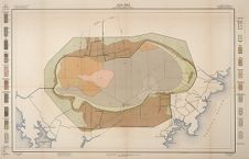
- Color map showing areas of different types of soil at Lake Mattamuskeet in Hyde county, N.C. From Soil survey of the Lake Mattamuskeet Area, North Carolina. Washington : U. S. Government Printing Office, 1910. Includes legend.
- Date
- 1909
- Original Format
- maps
- Extent
- 82cm x 53cm
- Local Identifier
- S599.L3 H42x 1910
- Creator(s)
- Contributor(s)
- Subject(s)
- Spatial
- Location of Original
- Joyner NC Stacks
- Rights
-
This item has been made available for use in research, teaching, and private study. Researchers are responsible for using these materials in accordance with Title 17 of the United States Code and any other applicable statutes. If you are the creator or copyright holder of this item and would like it removed, please contact us at als_digitalcollections@ecu.edu.
http://rightsstatements.org/vocab/InC-EDU/1.0/ - Permalink
- https://digital.lib.ecu.edu/15960
- Preferred Citation
- Cite this item
- This item
-
 Soil map, North Carolina, Lake Mattamuskeet sheet
- My Collections Login
- Printable Feedback Form
- Found in theme/project
-
 Agriculture
-
 North Carolina History and Fiction Collection
Related Search Results
Public access is provided to these resources to preserve the historical record. The content represents the opinions and actions of their creators and the culture in which they were produced. Therefore, some materials may contain language and imagery that is outdated, offensive and/or harmful. The content does not reflect the opinions, values, or beliefs of ECU Libraries.
Contact Digital Collections
If you know something about this item or would like to request additional information, click here.
Comment on This Item
Complete the fields below to post a public comment about the material featured on this page. The email address you submit will not be displayed and would only be used to contact you with additional comments or questions.