| 56TH CONGRESS, 2d Session. | HOUSE OF REPRESENTATIVES. | DOCUMENT No. 180. |
EXAMINATION AND SURVEY OF WILMINGTON HARBOR AND CAPE FEAR RIVER, NORTH CAROLINA.
LETTERFROM
THE SECRETARY OF WAR,
TRANSMITTING,
WITH A LETTER FROM THE CHIEF OF ENGINEERS, REPORTS OF EXAMINATION AND SURVEY OF WILMINGTON HARBOR AND OF CAPE FEAR RIVER, NORTH CAROLINA.
DECEMBER 11, 1900.—Referred to the Committee on Rivers and Harbors and ordered to be printed.
WAR DEPARTMENT,
Washington, December 8, 1900.
SIR: I have the honor to transmit herewith a letter from the Chief of Engineers, United States Army, dated December 6, instant, together with reports of Capt. E. W. Van C. Lucas, Corps of Engineers, dated August 9 and November 24, 1900, of a preliminary examination and survey of Wilmington Harbor, North Carolina, with a view to providing a sufficient width and depth to permit vessels now using said harbor to turn or swing around therein, and of Cape Fear River, with a view to obtaining a navigable channel from Wilmington to Fayetteville of 4, 6, or 8 feet at mean low water, made in compliance with the emergency river and harbor act of June 6, 1900.
Very respectfully,
ELIHU ROOT,
Secretary of War.
The SPEAKER OF THE HOUSE OF REPRESENTATIVES.
OFFICE OF THE CHIEF OF ENGINEERS, UNITED STATES ARMY,
Washington, December 6, 1900.
SIR: I have the honor to submit herewith copies of reports dated August 9, 1900, and November 24, 1900, by Capt. E. W. Van C. Lucas, Corps of Engineers, upon preliminary examination and survey,
respectively, authorized by the emergency river and harbor act approved June 6, 1900, as follows:
Wilmington Harbor: With a view to providing a sufficient width and depth to permit vessels now using said harbor to turn or swing around therein, Cape Fear River, with a view to obtaining a navigable channel from Wilmington to Fayetteville of four, six, or eight feet at mean low water.
This item of the act relates to two distinct propositions, which it will be necessary to treat separately.
Wilmington Harbor has been under improvement by the United States for many years, and owing to its commercial importance is regarded by both the local officer and the division engineer, Col. Peter C. Hains, Corps of Engineers, as worthy of further improvement. The plan proposed by Captain Lucas for furnishing a sufficient width and depth to permit vessels to swing and turn in the harbor provides for dredging an anchorage basin in the lower part of the harbor at an estimated cost of $291,500. In the opinion of Colonel Hains an anchorage basin of the kind called for by the act is unnecessary, and therefore is not a work worthy of being undertaken by the General Government. In lieu of such an anchorage basin, he suggests the plan adopted at Savannah, where the conditions are similar to those at Wilmington, which is to construct mooring dolphins, to which vessels may be secured without the necessity of anchoring. A suitable number of dolphins established alongside of the ship channel, but not in it, together with such dredging as may be necessary, would cost, he estimates, $30,000.
Cape Fear River from Wilmington to Fayetteville is at present being improved under a project which provides for removing obstructions and obtaining a continuous channel by means of jettying and dredging. By this method Captain Lucas thinks it will not be possible to secure a certain depth at all seasons of 4 feet, which is the least depth contemplated by the act of June 6, 1900. By the construction of locks and dams the depth of 4 feet could be obtained with certainty. The cost of such an improvement is estimated at $1,320,000, and this work is recommended by the local officer. By increasing the lift of the locks and doing some dredging the maximum depth of 8 feet could be obtained, and the increased cost is estimated at not to exceed $30,000. In view of this small difference in the estimated cost for obtaining channels for 4-foot and 8-foot navigation, no estimate is submitted for the medium depth of 6 feet named by the act.
Colonel Hains, the division engineer, invites attention to the fact that in these estimates no provision is made for maintenance of the improvement when completed, and states that in view of the small additional cost of an 8-foot over a 4-foot navigation the former depth is to be preferred if the plan for slack-water improvement be adopted. He concludes his indorsement of November 30, 1900, with the statement that “while I am of the opinion that the Cape Fear River is worthy of improvement, I can not subscribe to the opinion that it is worthy of improvement at the present time to the extent herein indicated.”
Very respectfully, your obedient servant,
JOHN M. WILSON,
Brig. Gen., Chief of Engineers,
U. S. Army.
Hon. ELIHU ROOT,
Secretary of War.
PRELIMINARY EXAMINATION OF WILMINGTON HARBOR, NORTH CAROLINA, WITH A VIEW TO PROVIDING A SUFFICIENT WIDTH AND DEPTH TO PERMIT VESSELS NOW USING SAID HARBOR TO TURN OR SWING AROUND THEREIN, AND OF CAPE FEAR RIVER WITH A VIEW TO OBTAINING A NAVIGABLE CHANNEL FROM WILMINGTON TO FAYETTEVILLE OF 4, 6, OR 8 FEET AT MEAN LOW WATER.
UNITED STATES ENGINEER OFFICE,
Wilmington, N. C., August 9, 1900.
GENERAL: In compliance with instructions contained in letter from your office dated July 3, 1900, I have the honor to submit the following preliminary report on—
Wilmington Harbor: With a view to providing a sufficient width and depth to permit vessels now using said harbor to turn or swing around therein: Cape Fear River, with a view to obtaining a navigable channel from Wilmington to Fayetteville of four, six, or eight feet at mean low water.
This proposed improvement includes two distinct items: First, an anchorage basin at Wilmington, and second, the deepening of Cape Fear River channel between Wilmington and Fayetteville to 4, 6, or 8 feet.
Concerning (1) the proposed and orage basin at Wilmington. The river at Wilmington has a maximum width, for 20 feet or greater depth, of about 600 feet, which is not enough to enable large steamers to swing at anchor. It is proposed to dredge a suitable basin in the lower part of the harbor, where the present width of the river is 1,200 to 1,500 feet.
Wilmington is the principal seaport of the State, and in 1899 its river and sea commerce amounted to more than 600,000 tons, valued at over $33,000,000. Its present need of an anchorage basin is apparent, and this need must become more and more pressing with the increasing importance of the principal and only important seaport of a State the natural resources of which are yet comparatively undeveloped, although just entering a stage of active development.
No survey is necessary for the preparation of estimates, the data for which can be obtained from records and maps in the office of the “Improvement of Cape Fear River at and below Wilmington, N. C.;” consequently no allotment will be needed for this part.
In my opinion, the proposed improvement is a worthy one and I recommend that I be authorized to submit the necessary plans and estimates.
Concerning (2) the proposed deepening of Cape Fear River channel between Wilmington and Fayetteville to 4, 6, or 8 feet: This proposed improvement particularly affects the town of Fayetteville, 115 miles by river from Wilmington, and involves the improvement of about 70 miles of river on which the governing ordinary low-water depth is now about 2 feet, and during extreme low-water stages only 6 inches. Such an improvement will also be of ultimate great benefit to the intervening country, which, however, is now undeveloped.
Fayetteville is a flourishing town at the head of navigation, was formerly a very important distributing point for a large section of country, and is now of rapidly growing importance as a manufacturing center. The extent of its present interests is indicated in the accompanying letter from its chamber of commerce. Particular attention is invited to the statement therein as to “the certain prospect of electric power at $15 per horsepower per annum.” This statement I know to be founded on fact, and I also know that it can be very
greatly extended by the utilization of available water power of the Cape Fear River and its tributaries above Fayetteville. There is no apparent reason why electric power can not be applied there with equal or greater success than that achieved at the great mills at Pelzer, S. C.
The present annual commerce on the river is about 50,000 tons, even on a limiting draft of 2 feet or less, and manufacturers at Fayetteville assure me that they would gladly take much greater advantage of river transportation if they could depend on certain trips by river steamers insuring connection with coast wise steamers from Wilmington. They inform me that such means of transportation, when connections at Wilmington can be made, is now cheaper and quicker to New York than rail transportation.
For the bulk of their freighting they are now dependent on the railroads entering Fayetteville, all of which are controlled by one corporation, thus practically destroying competition.
The present project contemplates obtaining “a continuous channel (depth not stated) to Fayetteville,” and the estimated amount needed to complete it is $135,750. If a new project is adopted, the above amount will be included in its estimated cost.
In my opinion the river is worthy of further improvement by the General Government, and I recommend that authority be granted to make the necessary survey, at an estimated cost of $2,500, of which amount $1,000 is available from the balance to the credit of “improvement of Cape Fear River above Wilmington,” and the remainder should be allotted from funds appropriated by emergency river and harbor act of June 6, 1900.
Very respectfully,
E. W. VAN C. LUCAS,
Captain, Corps of Engineers.
Brig. Gen. JOHN M. WILSON,
Chief of Engineers, U. S. A.
(Through the Division Engineer.)
[First indorsement.]U. S. ENGINEER OFFICE,
Baltimore, Md., August 13, 1900.
Respectfully submitted to the Chief of Engineers, U. S. A.
Wilmington Harbor and the Cape Fear River from that harbor to Fayetteville are both worthy of improvement by the Government, or, rather, continued improvement, as both have received such attention from the United States.
The extent to which the Upper Cape Fear River should be improved can be best determined after a survey is made.
The views of the district engineer are recommended for approval.
* * * * * * *
PETER C. HAINS,
Colonel, Corps of Engineers,
Division Engineer, Southeast Division.
[Second indorsement.]OFFICE CHIEF OF ENGINEERS,
U. S. ARMY,
August 17, 1900.
Respectfully submitted to the Secretary of War.
This is a report upon preliminary examination of Wilmington Harbor, North Carolina, and of Cape Fear River from Wilmington, N. C., to Fayetteville (full text of item quoted within), made to comply with the requirements of the emergency river and harbor act of June 6, 1900.
The proposed anchorage basin at the harbor of Wilmington and the improvement of the Cape Fear River from Wilmington to Fayetteville are, in the opinion of the local officer and of the division engineer, considered as work worthy of being undertaken by the General Government.
No survey is required for the preparation of plan and estimate of cost of the proposed anchorage basin, the necessary data being already available, but a survey will be necessary to prepare plan and estimate of cost of improvement between Wilmington and Fayetteville. I recommend that the local officer be directed to submit the necessary plan and estimate for obtaining the proposed anchorage basin, and also that a survey of the river between Wilmington and Fayetteville, including preparation of plan and estimate, be authorized.
JOHN M. WILSON,
Brig. Gen., Chief of Engineers,
U. S. Army.
[Third indorsement.]WAR DEPARTMENT,
August 18, 1900.
Approved as recommended by the Chief of Engineers.
ELIHU ROOT,
Secretary of War.
LETTER OF THE FAYETTEVILLE (N. C.) CHAMBER OF COMMERCE.CHAMBER OF COMMERCE,
Fayetteville, N. C., August 8, 1900.
DEAR SIR: The Fayetteville Chamber of Commerce desires to call your attention to the great necessity which exists for the improvement of the navigation of the Cape Fear River from Wilmington, N. C., to Fayetteville, N. C., the head of its navigable waters. Fayetteville, N. C., for almost a century enjoyed the advantage and distinction of being, commercially, the most important inland town in the State. This condition was brought about by its position at the head of the Cape Fear River, upon whose splendid waters all the heavy shipments of salts, iron, molasses, coffee, and merchandise generally found their way through Fayetteville all over the western counties of the State, reaching into East Tennessee and into the States to the north and south of us. The building of railroads in the last quarter of a century and more deflected these shipments elsewhere, and the Cape Fear River did not receive that attention which its importance to the people of a large section of North Carolina would seem to have warranted. Latterly Fayetteville, N. C., has attracted the attention of several manufacturing capitalists, and is beginning to be regarded as a promising manufacturing center, as is shown by the following industries, the most of which have been erected very recently here and in vicinity.
Hope Mills, 15,000 spindles, 750 looms; Holt Morgan Mills, 10,000 spindles, 500 looms; Holt Williamson Mills, 5,200 spindles; Fayetteville Cotton Mills, 3,120 spindles; Bluff Mills, 200 looms; Murchison Mills, 3,000 spindles, 100 looms; Cumberland
Mills, 3,000 spindles; Ashely-Baily Silk Mills, 100 looms; La Fayette Knitting Mills; Lacy Manufacturing Company Furniture Mills; Fayetteville Cotton Oil and Fertilizer Company, 40 tons daily; Carolina Machine Shops; Ward's Foundry; Emmitt's Roller Corn Mill; Williams Furniture Factory; McNeill's Roller Rice and Grist Mill; Clark's Machine Shop; Carolina Roller and Grist Mill; Watson Planing Machine Mill; Tobacco warehouse; Fayetteville Wooden Ware Company; Tolar Hart Holt Mills, 15,000 spindles; E. A. Poe's Brick Yard Works; several sawmills and other industries.
All these produce vast amount of freight, and many of these works already use the river in their transportation and in this way enjoy a large profit in saving on freights alone. The present tonnage of river freights is 50,000 tons, but if water could be assured the year round, even with the present river transportation facilities and the present business, there would be no trouble in increasing the tonnage 100 or even 150 per cent. But we have in the near future the certain prospects of electric power at $15 per horse per annum. This will in a few years (with our other advantage) bring a great many new and important industries to our city. We know of three very large ones that will come here certainly as soon as the electric power reaches us. This is to be produced by the waters of the Cape Fear River at a point some miles above us, and the fact of its coming here seems to be well assured. It is almost impossible for us to estimate the amount of freight in tons that would seek the river transportation if a regular depth of water was assured. But from the great advantage in freight rates that would favor water transportation we know that several more steamboats would go on at once, and that soon the Cape Fear River would regain its old-time importance, blessing a large section of the State by its beneficent freight rates.
Fayetteville, N. C., is a port of entry, and the Cape Fear River is under the control of the Government. There is no stream in North Carolina that will bring so much in return for every dollar expended upon its improvement by the Government.
Yours, truly,
F. R. ROSE,
Secretary Chamber of Commerce.
Capt. E. W. VAN C. LUCAS,
United States Engineer.
PLAN AND ESTIMATE OF COST OF PROVIDING A SUFFICIENT WIDTH AND DEPTH IN WILMINGTON HARBOR, NORTH CAROLINA, TO PERMIT VESSELS NOW USING SAID HARBOR TO TURN OR SWING AROUND THEREIN, AND SURVEY OF CAPE FEAR RIVER WITH A VIEW TO OBTAINING A NAVIGABLE CHANNEL FROM WILMINGTON TO FAYETTEVILLE OF 4, 6, OR 8 FEET AT MEAN LOW WATER.
UNITED STATES ENGINEER OFFICE,
Wilmington, N. C., November 24, 1900.
GENERAL: In compliance with letter from your office dated August [illegible text] 1900, I have the honor to submit the following report on proposed anchorage basin at Wilmington, N. C., and proposed improvement of Cape Fear River between Wilmington and Fayetteville, N. C. This survey was authorized under the emergency river and harbor act of June 6, 1900, as follows:
Wilmington Harbor: With a view to providing a sufficient width and depth to permit vessels now using said harbor to turn or swing around therein; Cape Fear River, with a view to obtaining a navigable channel from Wilmington to Fayetteville of four, six, or eight feet at mean low water.
The above authority includes two distinct items, which will be considered separately.
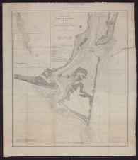
(1) WILMINGTON HARBOR, ANCHORAGE BASIN.Wilmington, the principal seaport of North Carolina, is situated on the Cape Fear River about 30 miles from its mouth, and has access to the sea by a channel with least low-water depth of 20 feet and least
high-water depth of 22 feet. The accompanying map shows the harbor and the city water front. The city had an annual commerce in 1899 estimated at over 600,000 tons, valued at over $33,000,000; and for the current year it is claimed that there will be a considerable increase in tonnage, and that the total valuation will amount to $40,000,000. The greater part of this commerce is carried on steamers and sailing vessels drawing from 15 to 21 feet, many of them 300 to 350 feet long.
Before proceeding to their wharves for discharging and loading, these large vessels are generally delayed waiting for orders, during which time they are compelled to anchor.
The present anchorage facilities for 20 feet or greater depth are of the poorest, and limited to the deep-water channel opposite the center of the city, with a greatest width of about 600 feet, which gradually narrows to about 150 feet width in the dredged channel below. At its best, a width of 600 feet does not afford swinging room for a vessel 300 feet long, and the widest channel available is in the busiest part of the harbor, and vessels anchoring there become an impediment to its business. If anchored in the narrower and shoaler channel below, they are likely to ground or to foul their anchors. The harbor master states that during the last year 25 to 30 vessels have gone aground while at anchor, some of which have resulted in serious injury, with consequent damage claims.
It is therefore evident that this port has no adequate anchorage facilities, and as a consequence it is becoming more and more difficult to charter large vessels for this port, which places it at a distinct disadvantage. No large vessel can now anchor in this harbor without danger of grounding or without interfering with business, and possible accident.
Estimates have been prepared for an anchorage basin opposite the lower end of the city, with a width of 1,200 feet and a length of 3,000 feet. These dimensions, giving an area of over 80 acres, will afford room for an ample channel through the center and anchorage on each side of such center channel for four large steamers, moored fore and aft. The estimated depth is 28 feet at low water, which will give sufficient room under the keels of vessels to avoid danger from fouling anchors. The harbor master informs me that such an anchorage basin would be satisfactory and afford ample accommodations for the present needs of the port. As these needs increase the dredged basin can be extended downstream for 6,000 to 8,000 feet, with width increasing up to 2,000 feet. Estimates are also submitted for dredging to 20 feet depth the approaches to the anchorage basin from both directions, so as to make it easily accessible. These estimates are as follows:
| For anchorage basin, as shown, 2,052,000 cubic yards, at 10 cents | $205,200 |
| Up-river approach, 412,000 cubic yards, at 10 cents | 41,200 |
| Down-river approach, 186,000 cubic yards, at 10 cents | 18,600 |
| Superintendence and contingencies, 10 per cent | 26,500 |
| Total | 291,500 |
Such an anchorage basin, if approved, will involve an unimportant alteration of the lower end of the approved harbor line on the city side, which at present is a straight line from A to C on accompanying map, but which, if above project is approved, should be changed to the broken line A B C. There is no likelihood of objection to such a change in harbor line, as it will interfere with no existing structures, and, on the contrary, will give deeper water at the wharf heads.
Such an anchorage basin, at a cost of $291,500, will benefit a commerce now estimated at $33,000,000 annually, with every prospect of steady increase, and, for the reasons above stated, is, in my opinion, a worthy improvement, and I recommend that it be undertaken by the United States.
Attention is respectfully invited to the accompanying letters from the Chamber of Commerce, Produce Exchange, and Merchants’ Association, all of Wilmington, and from Alexander Sprunt & Son, the largest individual shippers in the city.
(2) IMPROVING CAPE FEAR RIVER BETWEEN WILMINGTON ANDFAYETTEVILLE.
The object of this improvement is to obtain all the year round depth of not less than 4 feet, which will involve the improvement of about 70 miles of river on which the present governing depths are 2 feet at ordinary low water and 9 inches at extreme low water. Such low-water depths now result in a practical suspension of navigation during three or four months annually, with the result that the stream is useless for purposes of navigation during a third of the year, and much business which would go to it if certain navigation were assured is now always shipped by rail and at a higher rate.
The estimated present commerce is about 115,000 tons annually, valued at $1,150,000, and with navigation all the year round this present business would probably at once increase at least 50 per cent, to over 170,000 tons, valued at about $1,700,000. With certain navigation throughout the year, much of the product of about forty mills now operating at and near Fayetteville would be shipped by river to Wilmington, and thence by steamer to the North, instead of, as now, by rail to Norfolk and thence by steamer to the North. This Fayetteville mill product has an estimated value of $5,800,000, of which three-fourths, valued at $4,350,000, could be shipped by river. This makes a total of about $6,000,000 worth of annual present shipments which would probably utilize the river if certain navigation were established.
As to probable development resulting from the improved navigation, it is claimed in Fayetteville that twelve or fifteen mill enterprises, some with capital already subscribed, are only waiting assurance of certain river navigation to begin the construction of buildings and plant at that city.
There is also a possibility, and perhaps a probability, of the improvement of the river resulting in the reestablishment of Fayetteville as a distributing point for a large section of country. This point is brought out and explained in the accompanying letter from the Fayetteville citizens’ committee, their claim being that Fayetteville would, under such circumstances, become such distributing point for a section of country the business of which is estimated in their letter at 6,000,000 tons annually, valued at $165,000,000.
With certain navigation there would be a probable development of the Cape Fear River Valley, much of which is good farming land. Under present conditions the success of a year's crop depends entirely on the use of the river for transportation to market. During low-water stages the farmers have the alternative of a long, costly haul, or the loss of their crop, if perishable. This section of the country is also interested in the proposed improvement because it will afford much better mail and passenger carrying facilities than now exist.
The wholesale merchants of Wilmington are much interested in the proposed improvement because it means to them a chance of extending their business to Fayetteville and vicinity, which they can not now get because unable to compete with merchants of Richmond and Norfolk, Va., on account of existing rail rates, although Fayetteville is only 83 miles by rail from Wilmington, while it is 211 miles by rail from Richmond and 204 miles from Norfolk.
The interest of Fayetteville is much greater than that of Wilmington, because, although at the head of navigation, its water route to the North can not now compete with the rail routes. North-bound shipments are now usually sent by rail to Norfolk, and thence by water north. All railroads now entering Fayetteville belong to one system, and there is practically no competition. The accompanying letter from the citizens of Fayetteville states the case in a concise and comprehensive form, and shows a probable immediate business affecting Fayetteville of approximately $5,500,000 annually. Reference has already been made to the possible much greater interest affected if the improvement of the waterway resulted in the establishment of Fayetteville as a distributing point.
Estimates are called for to obtain a depth of 4 feet, 6 feet, or 8 feet at all seasons. The least depth mentioned, 4 feet, can, in my opinion, be obtained with certainty only by a system of locks and dams, as the low-water discharge at Fayetteville is about 212 cubic feet per second, and the fall in the 70 miles below Fayetteville about 20 feet.
The river has been under improvement about twenty years, under a project to clear the river to Fayetteville and obtain a continuous channel—depth not stated—by jettying and dredging, at a cost estimated, in 1893, at $275,000, of which about half has been spent. The appropriations have been spread over so many years, and in such small amounts, that the improvement thus far attained is local in character, and the present governing depth between Wilmington and Fayetteville is little, if any, better than it was twenty years ago. With an expenditure of $135,000, in addition to as much already spent, it is believed that the low-water depth can be increased about 1 foot, making the governing depth 21 inches, instead of about 9 inches, as at present. I do not believe it possible to obtain a navigable channel of 4 feet certain depth at all seasons by jettying and dredging.
The minimum depth proposed; 4 feet, can be obtained with certainty by the construction of three locks with movable dams, the locations of which are approximately shown in the accompanying profile sheet of the Cape Fear River; such locks to have a lift of 8 feet. By making the lift 9 feet, instead of 8 feet, and doing a little dredging, the maximum proposed depth, 8 feet, could be obtained. The difference in cost of 4 feet and 8 feet navigation would probably not exceed $30,000; a little over 2 per cent of the cost of obtaining 4 feet navigation. This difference between costs for 4 feet and 8 feet navigation is so small that it is not deemed necessary to estimate the cost of the intermediate depth of 6 feet.
The form of lock and dam proposed is similar to those used in Kanawha River, and consists of a lock of 8 feet lift, with a chamber 150 feet long and 28 feet wide, and a movable dam about 170 feet long. Such a lock will accommodate any boat capable of navigating the river. Movable dams are deemed necessary because the river is subject to freshets ranging from 40 to 60 feet at Fayetteville to 20 to 30 feet at the lowest proposed lock.
The estimate is as follows:
| Three locks, as above described, with movable dams, $400,000 each | $1,200,000 |
| Superintendence and contingencies, 10 per cent | 120,000 |
| Total | 1,320,000 |
This estimate may appear excessive, but it should be borne in mind that there is no solid rock for foundations, and the estimates are based on bottom of foundations at about 28 feet below low-water surface. In addition, the stream has caving banks, necessitating bank protection for an unusually long distance below each dam, to protect from scour.
This proposed expenditure of $1,320,000 is for the benefit of an actual present commerce valued at about $6,000,000 annually, on which, according to the Fayetteville citizens’ letter, there would be a resulting saving in rates of about $70,000 annually, which is over 5 per cent of the estimated cost. On this basis, and for the reasons outlined above and elaborated in the accompanying letters from the citizens’ committee of Fayettville, and the chamber of commerce, produce exchange, and Merchants’ Association of Wilmington, I consider the improvement a worthy one and recommend that it be undertaken by the United States.
There are forwarded herewith, under separate cover, a map of Wilmington Harbor, one sheet1 of profiles of Cape Fear River between Wilmington and Fayetteville, and two sheets1 of cross sections of river bed and valley at proposed lock and dam sites.
Respectfully submitted.
E. W. VAN C. LUCAS,
Captain, Corps of Engineers.
Brig. Gen. JOHN M. WILSON,
Chief of Engineers, U. S. A.
(Through the Division Engineer.)
[First indorsement.]U. S. ENGINEER OFFICE,
Baltimore, Md., November 30, 1900.
Respectfully submitted to the Chief of Engineers, U. S. A.
There is a lack of room for large vessels to anchor in front of Wilmington, as is the case in many other places of equal commercial importance, but the construction of an anchoring basin 28 feet deep is an expensive method of meeting the difficulty. The plan adopted in the Savannah River, where the conditions are similar, would seem to meet the case here in a much less expensive way. The plan adopted there is to construct mooring dolphins to which vessels may tie up without the necessity of anchoring. A suitable number of dolphins established alongside of the ship channel, but not in it, together with such dredging as may be necessary, would, it is believed, not cost more than $30,000, one-tenth the cost of an anchoring basin, and be equally satisfactory to navigation.
The act under which this survey is made calls for a report on the question of “providing a sufficient width and depth to permit vessels now using said harbor to turn or swing around therein.” I am of the opinion that an anchorage basin of that kind is unnecessary, and therefore it is not a work worthy to be undertaken by the General Government.
1 Not printed.1 Not printed.In respect to the project of 4, 6, or 8 feet depth at mean low tide from Wilmington to Fayetteville, the district engineer submits a plan for 8 feet by means of locks and movable dams, at an estimated cost of $1,350,000. Nothing, however, is provided for maintenance or operation.
It is to be remembered that with a slack-water navigation made by locks and movable dams there is an annual cost for operating, as well as maintenance. Skilled employees to operate the locks, as well as to lower and raise the dams, are required, and dredging and snagging will still be necessary.
The amount appropriated for this river in the past sixteen years has only averaged about $8,000 per annum. This is not one-third enough to operate and maintain a slack-water navigation. If, therefore, locks and dams had been in existence during this period, the navigability of the channel could not have been maintained on the sums appropriated. The heavy freshets to which this stream is subjected, rising as it does as much as 50 to 60 feet at Fayetteville, brings down great quantities of sediment and great numbers of logs and trees. These logs and trees must be removed and some dredging done annually whether the improvement be by locks and dams or otherwise. In my judgment it would require an annual expenditure of about $30,000 to operate and maintain this improvement.
That the prospective business may reach the value of $165,000,000 annually, as estimated, if the river be improved as recommended, I do not believe. Moreover, much of the prospective business would not be in the nature of an increase, but merely a diversion to Fayetteville and Wilmington of business already existing at other points.
The improvement of this upper river by means of locks and movable dams is an expensive one, and after it be completed, if it is to be efficiently maintained, much larger appropriations must be made annually than has formerly been the case. The cost of an 8-foot navigation is so little in excess of the cost of a 4-foot navigation that the 8-foot depth is by all means the one to be preferred if the plan of slack-water navigation be adopted.
While I am of the opinion that the Cape Fear River is worthy of improvement, I can not subscribe to the opinion that it is worthy of improvement, at the present time, to the extent herein indicated.
PETER C. HAINS,
Colonel, Corps of Engineers,
Division Engineer, Southeast Division.
LETTER OF A COMMITTEE OF CITIZENS OF FAYETTEVILLE, N. C.FAYETTEVILLE, N. C., November 21, 1900.
SIR: The undersigned, the committee appointed at the citizens’ meeting held on the occasion of your visit on Thursday last, have taken up the subjects of inquiry suggested by you, and have pleasure in reporting as follows:
THE PRESENT RIVER TRAFFIC.The tonnage of the traffic by the steamboats between this city and Wilmington, as reported by the United States engineer office at Wilmington for the year ending December 31, 1899, was, in round numbers, 115,000. We are informed that its value would average $10 per ton, which would give a total value of $1,150,000.
EXISTING LOCAL RAILWAY TRAFFIC WHICH WOULD SEEK THE RIVER IF IMPROVED.
In reply to printed forms issued to our merchants, traders, and manufacturers, made out, when necessary, under supervision, we find that there have been received at and shipped from Fayetteville by rail during the past twelve months 112,295 tons of merchandise of all kinds, valued at $5,812,614. It is estimated that at least three-fourths of this would at once be diverted to the river for transportation if the proposed improvement were made and the speedy and regular dispatch of freights which it would make possible were established.
TRAFFIC FROM A DISTANCE WHICH WOULD BE DIVERTED TO THE RIVER IF FAY-ETTEVILLE WERE MADE A “BASING POINT.”
We are informed that as soon as the proposed improvement in navigation and the dispatch of freights is effected Fayetteville would be made what the traffic managers call a basing point for freight rates. The effect of this, we are informed, will be to cause all railways which run within the territory thus tributary to Fayetteville to make rates from Fayetteville. By the term “the territory thus tributary to Fayetteville” we mean all the country which is nearer to Fayetteville than to any other basing point, the railway commission laws requiring the rates therein to be proportionately less than to such other basing points.
We inclose a map1 * * * which will show the territory thus delimited as tributary to Fayetteville. The basing points nearest to Fayetteville are Richmond and Norfolk, Va., on the north, and Charleston, S. C., on the south. We have drawn lines at right angels across air lines between Fayetteville and the three cities named, respectively, and at points midway between Fayetteville and them. Line A is the dividing line between Richmond and Fayetteville; line B, the dividing line between Norfolk and Fayetteville and line C that between Charleston and Fayetteville. It will be seen that, while the northeast section of North Carolina falls within the territory allotted to Richmond and Norfolk, a considerable portion of southwest Virginia and a considerable portion of northeast South Carolina, each larger than the first mentioned, fall within the territory of Fayetteville. As the improvements referred to would also cause Wilmington to be made a basing point, the map would be changed thereby to a comparatively small extent, the effect of the change being to add more to the joint territory of Wilmington and Fayetteville.
We also inclose a copy of a United States Government report on the Manchester Ship Canal1 * * * in which is described (pp. 5-9) the manner employed in Great Britain for “proving” a commercial reason for the granting of a charter by Parliament for such an undertaking. We shall, in this case, employ the same method, in a general way, because such matters in the older countries have necessarily reached a more exact standard. An important consideration in our favor in relying upon such a method is the fact that the railway commission laws in this country now require connecting lines to transport freight delivered to them, whether a tariff of through rates has been established or not, and, as before mentioned, at rates proportioned to the “length of haul.”
Without entering upon a consideration of how far westward beyond the borders of North Carolina the traffic influence of the proposed improvements would extend, we ask attention to the significant coincidence that the territory now delimited on our map is almost the same as that which was tributary to Fayetteville in the last of the eighteenth century, in the first part of the present century, and up to the railroad era. The fact that Canova's statue of Washington was brought from Italy to Wilmington, was thence landed at Fayetteville, and finally hauled overland to Raleigh in the latter period is merely an illustration of the general conditions of transportation at that time.
The proposed improvement, therefore, would not establish a novel condition, but would restore the normal relation of the Cape Fear to a vast territory, which the overworking of the railroad idea and the effect of deforestation upon the water courses have disturbed; or we may state the case this way—that it would be the reestablishment of normal conditions by a development of the problem of transportation, which conditions had been disturbed by a cruder stage of the movement.
Within the limitations of our map, as thus restricted, it will be seen that there is a population equal to that of the State of North Carolina (some 1,900,000). The population which by a liberal estimate might be considered as involved, in one way or another, in the production of the existing river traffic and the existing railway traffic divertible to the river, in and out of Fayetteville, may be said to
1 Not printed.1 Not printed.include that of Cumberland County, in which Fayetteville lies (30,000), and one-fourth of that of the contiguous counties of Sampson (7,000), Bladen (5,000), Robeson (9,000), Moore (6,000), and Harnett (4,000)—a total of 61,000. The territory, then, on the map, this side of the Blue Ridge, contains a population thirty times as great as the population at present tributary to Fayetteville.
We therefore have this proposition:
| Tons. | Value. | |
| Existing river traffic | 115,000 | $1,150,000 |
| Three-fourths (the divertible portion) of existing railway traffic in and out of Fayetteville—three-fourths of 112,295 tons and three-fourths of $5,812,614 | 84,221 | 4,359,460 |
| In round numbers | 200,000 | 5,500,000 |
| Thirty times these figures would give the tonnage and value of traffic which, other things being equil, would find a cheaper route to and from the great markets by way of the Cape Fear River if improved as suggested—that is, 30 by 200,000 tons and 30 by $5,500,000 | 6,000,000 | 165,000,000 |
In this connection it is worth noting that Mr. Walter L. Holt, one of the chief owners of cotton mills in this county and in Alamance County, 100 miles distant, finds that he gets his oils, dyes, and machinery and ships his finished products by river from his Fayetteville (Cumberland) mills for an average of but half the freight rate which he is obliged to pay by rail to and from his Alamance mills.
THE RAILWAY COMMISSION'S FIGURES.We further inclose a letter from the North Carolina corporation (railway) commission, * * * from which it will be seen that the actual freight traffic movement for the past year over the roads converging at Fayetteville, and within the territory indicated on our map, amounted to 1,497,976 tons, or one-fourth of the tonnage (6,000,000) which we have estimated by the per capita method for the whole territory east of the mountains. It will be observed also that the commission's letter expresses the hope that “the Government will see the importance of this station (Fayetteville), which, by reason of its situation, should again become the distributing point for the central and western North Carolina territory.”
Attention may also be called to the fact that Fayetteville, at the head of navigation, 100 miles inland, is the only point on the Atlantic Coast Line between Richmond and Charleston (the present basing points) which is situated on navigable water.
How far the inertia of settled routes of trade may act in restraint of the possibilities indicated above is, of course, a matter of conjecture.
THE COMMERCIAL CASE.We assume that while the Government undertakes works of the kind now proposed for the public benefit, and without expectation of a direct return for its outlay, it is nevertheless influenced by the same considerations which influence private capitalists. That is to say, if the cost of the proposed improvement should be $1,000,000, it would be a sound commercial undertaking, commending itself to the Government from this point of view, if the additional traffic secured by reason of the outlay, or the resultant economies of transportation on existing traffic, should yield 5 per cent on that amount. Five per cent on $1,000,000 is $50,000.
It is apparent that the economies of transportation which such an improvement would render possible—twelve months’ running of the boats instead of nine months, the cheaper proportionate handling of larger loads, etc.—would leave a margin for tolls for the use of the improved waterway, if the work were done by a private corporation, far in excess of the reasonable rate of 5 per cent on $1,000,000. An average of 25 cents a ton on the class of freight (115,000 tons) now carried by the river and 50 cents a ton on the class of freight (84,221 tons) now carried by the railways in and out of Fayetteville, but divertible to the river, would produce a revenue of $70,860, or over 7 per cent, on the existing Fayetteville traffic alone. A toll of 10 cents a ton would more than pay for the whole investment of $1,000,000 in two years if all the traffic of the tributary country were diverted this way. Such speculations as to what might be done if the river were the property of private capitalists instead of that of the Government are useful as
indicating how very far within the margin of commercial safety the Government would be acting if it should make such an expenditure.
We desire, in conclusion, to heartily reiterate for ourselves the expression of thanks which the meeting that appointed us unanimously voted to you, sir, for the interest which you have taken in this great work.
We remain, with high esteem, yours, obediently.
W. S. COOK,
Mayor of Fayetteville and Chairman of the Citizens’ Meeting.
E. J. HALE.
W. L. HOLT.
F. R. ROSE.
R. L. WILLIAMS.
W. M. MORGAN.
A. H. SLOCOMB.
H. C. BASH.
J. A. KING.
Capt. E. W. VAN C. LUCAS,
Corps of Engineers, U. S. A.
LETTER OF THE NORTH CAROLINA CORPORATION COMMISSION.DEPARTMENT OF THE NORTH CAROLINA CORPORATION COMMISSION,
Raleigh, November 20, 1900.
DEAR SIR: I have the honor to acknowledge receipt of your letter, bearing date November 19, asking for information touching the tonnage of freight moved over the railroads to and from Fayetteville.
Replying to this inquiry, I am very sorry to have to say that I can not give you the information as you desire it, as we do not receive at this office the tonnage movement from each station along the various lines of railroads in the State; but we do get the total tonnage of freight from the entire road, which compilation gives the freight originating on the road and freight received from connecting roads, together being the total freight tonnage handled by the road. This information I take pleasure in furnishing you, which you will find herewith inclosed.1 Table No. 1 is compiled from the last statement of the Cape Fear and Yadkin Valley Railway Company; Table No. 2 is for the Wilmington and Weldon Railroad (main line), including Wilson and Fayetteville branch and other of its branches proper.
I trust the statements will enable your committee to make an estimate of Fayetteville's proportionate amount of this tonnage. I am very glad to know that some steps are being taken toward opening up the Cape Fear River between Wilmington and Fayetteville, and I trust the Government will see the importance of this station, which by reason of its situation should again become the distributing point for the central and western North Carolina territory.
I am, sir, very respectfully.
H. C. BROWN,
Clerk.
Hon. E. J. HALE,
Chairman Citizens’ Committee, Fayetteville, N. C.
LETTER OF THE WILMINGTON (N. C.) CHAMBER OF COMMERCE.THE WILMINGTON CHAMBER OF COMMERCE,
Wilmington, N. C., November 19, 1900.
DEAR SIR: Your letter of the 12th duly received and referred to our committee on harbor, shipping, and commerce. Our chamber appointed a committee December 21, 1899, to ask for anchorage basin at Wilmington, feeling that the size and importance of our port, the largest and only deep-water port in the State, upon which the Government has expended large sums to give it 20 feet of water, require and need an anchorage basin, at which ships coming here can swing in safety,
1 Detailed figures omitted by Captain Lucas. The total tonnage amounts to 1,137,947 for Wilmington and Weldon Railroad; 360,032 for Cape Fear and Yadkin Valley Railway; total, 1,497,979.the present channel being too narrow to allow this. We are not prepared to care for vessels that this increased depth of water gives us. Our business has and is materially increased each year, and with this basin we will be in position to care for many more vessels and increased commerce.
This being a fresh-water port south of Hatteras, makes it particularly desirable for the shelter and care of smaller war ships and torpedo boats. From our geographical position we are particularly well situated for steamers trading between Cuban and Porto Rican ports, it being a shorter and safer route than any port north of Hatteras. We have good railroad facilities, capital, and energy, which will unite and make good use of these needed improvements. We are not prepared at this time to give statistics showing the present commerce of this port. This, no doubt, you have on file in your office, but if we can do anything to obtain this much-desired basin we will be pleased to do so.
Navigable rivers are sure and steady feeders, and those living near such streams receive many direct and indirect benefits. Before the time of railroads they were the channels upon which commerce moved. To-day they control and adjust rates made by railroads upon which commerce can move freely and cheaply. Therefore how necessary to the welfare of a country.
The Cape Fear River has been the great gateway for the people of North Carolina for many years, and even with its uncertain waters, being navigable only about eight months in the year, and then only to boats of very light draft—2 feet or under—has proven of inestimable value to the section through which it runs and is tributary thereto, particularly to the port of Wilmington. With increased depth of water, say 6 feet, the year round an immense tonnage will come this way, the people of our State will be materially benefited thereby, and the commerce and future of Wilmington be assured.
Our chamber appreciates highly the services rendered by you and the marked improvement of our river under your administration, and will gladly cooperate with you in any and all things tending to the continuance and improvement of this needed work.
Very respectfully,
MARCUS W. JACOBI,
President.
Capt. E. W. VAN C. LUCAS,
Corps of Engineers, U. S. A.
LETTER OF THE WILMINGTON (N. C.) PRODUCE EXCHANGE.WILMINGTON PRODUCE EXCHANGE,
Wilmington, N. C., November 19, 1900.
SIR: Replying to your favor of the 12th, the Produce Exchange heartily indorses the projects for dredging an anchorage basin at Wilmington and for obtaining a channel of 4 feet, 6 feet, or 8 feet depth throughout the year between Wilmington and Fayetteville.
First, as to the anchorage basin: The greatest width available for anchorage at Wilmington is 600 feet, just below the confluence of the Cape Fear and Northeast rivers, directly opposite the city, where the river is necessarily most crowded with vessels. This not only greatly interferes with the commerce of the port by rendering the passing of vessels very difficult, but at best is far too narrow to afford anchorage for the vessels coming to this port, as evidenced by the frequent grounding of vessels within this harbor on account of insufficient room for anchorage. The harbor master advises us that within the past year 25 to 30 vessels, drawing from 17 to 20 feet, have grounded in the lower harbor, as there is not sufficient room at that anchorage for the vessels to swing clear. The harbor master kept no record of these vessels, but the following have come under our special notice as having grounded within the past few months, namely: Bark Francis S. Hampshire, drawing 17½ feet; barge Carrie L. Tyler, drawing 17½ feet; steamship Strathord, drawing 19½ feet; steamship Dora, drawing 18 feet; steamship Mathilda, drawing 21½ feet.
Wilmington is the only port for foreign commerce in North Carolina, and the improvements made in the Cape Fear River below the city and on the bar, increasing the depth of the river from 12 to 20 feet and the water on the bar from 12 to 24 feet, enable vessels of a much larger class than heretofore to come to this port, which demands better facilities for anchorage than heretofore, and, as shown above, clearly demonstrates the insufficiency of present anchorage ground. The improvements above referred to have increased the annual commerce to and from
this port by water to over $35,000,000. However, each year greater difficulty is experienced in chartering vessels to come to this port on account of the knowledge of its insufficient anchorage spreading among the owners of vessels. This is seriously jeopardizing the present commerce of the port and preventing a much larger increase thereof.
Further, the proposed anchorage basin would serve as a fresh-water station for war vessels and cruisers of light draft, especially for torpedo boats and torpedo-boat destroyers, and would be the first available harbor south of the Chesapeake Bay.
Second, as to a channel of 4 feet, 6 feet, or 8 feet depth throughout the year from Wilmington to Fayetteville: The present annual tonnage above Wilmington on the Cape Fear River exceeds 115,000 tons, notwithstanding the fact that transportation by water between these points is at all times precarious, and during four months of the year well-nigh totally suspended on account of insufficient depth of water. If a channel of even 4 feet depth throughout the year could be obtained, so that transportation by water between these ports would be certain, a cheaper, shorter, and more direct route from Fayetteville to all markets would be secured in connection with the ocean steamers at Wilmington instead of by Norfolk, as at present; the fertile lands along the river would become available for trucking and other agricultural purposes now prohibited by absence of certain and quick transportation facilities: and shipments from this port by the river would soon reach 500,000 tons or more each year.
For these and many other reasons that might be assigned we firmly believe that an adequate anchorage basin for this harbor is an imperative necessity to maintain our present commerce, and that it would result in very largely increasing the same; also, that the proposed deepening of the channel between Wilmington and Fayetteville would prove a very material public benefit. In view of the interests involved and of the very great benefits that would accrue to the whole State from the carrying out of the proposed projects, we know of no object more worthy of the favorable consideration of those to whom these matters are to be submitted.
Thanking you for the courtesy in placing this matter before us, as also for the interest by you manifested in all things pertaining to the betterment of this port, we are
Very respectfully,
H. W. MALLOY,
H. G. SMALLBONES,
W. H. SPRUNT,
C. H. ROBINSON,
G. J. BONEY,
D. MCEACHERN,
Committee, Produce Exchange, Wilmington, N. C.
Capt. E. W. VAN C. LUCAS,
Corps of Engineers, U. S. A.
LETTER OF THE WILMINGTON (N. C.) MERCHANTS’ ASSOCIATION.WILMINGTON, N. C., November 20, 1900.
SIR: The undersigned, having been appointed by the Merchants’ Association of Wilmington a committee to advocate the adoption by the General Government of the projects provided in the river and harbor bill of last June under survey by the Corps of Engineers, United States Army, (1) for an anchorage basin at Wilmington, and (2) for a channel of 4 feet, 6 feet, or 8 feet depth, throughout the year, between Wilmington and Fayetteville, respectfully represent:
First, That the need of a safe anchorage in the port of Wilmington increases yearly with the progress of the bar and river improvements under the direction of the United States Engineers, and with a corresponding increase in the draft of larger vessels adapted to our growing commerce.
The channel from Cape Fear Bar to Wilmington, and at Wilmington, is only about 150 feet wide. This width barely accommodates the passage of large ships and is quite inadequate for anchorage at Wilmington. The depth of this dredged channel referred to is 20 feet; the outside of the channel in the lower harbor at Wilmington is only 13 feet to 15 feet depth. It is, therefore, obviously impossible to moor vessels of 18 feet to 21 feet draft and of 325 feet to 350 feet length in the stream without incurring great risk of grounding on their anchors, or of fouling moving craft in the fairway or mid-channel.
The lower harbor of Wilmington is a fresh-water, land-locked bay, about 1,200 feet wide and 2 miles long, well adapted for the anchorage and protection of a
large fleet of vessels, and for naval maneuvers, if the bottom was dredged to a depth of 28 feet in order that vessels drawing 22 feet may safely ride over the stocks and flukes of their anchors, which would require a depth of 6 feet more than that of the river and bar. In short, the work of the river and harbor is manifestly incomplete without this necessary accommodation to ships in port.
We are informed by the harbor master of Wilmington that more than thirty vessels have grounded under way and at anchor in the lower harbor within a year past, these casualties having been caused by insufficient water outside of the dredged channel in which to swing the vessels to their anchors. Several of these cases of stranding were of a serious character, the damage to a few loaded vessels resulting in general average claims. It should be understood that vessels arriving with inward cargo are required to anchor in the stream and wait orders for discharging, and that these incur the greatest risk of grounding, of obstructing the channel, and of collision with moving vessels.
The bottom of the lower harbor is also dangerous to navigation, being hard sand in which submerged logs have been embedded, thereby causing risk of damage to vessels’ bottoms and to the screws of steamships passing over it.
It is estimated that the commerce of Wilmington for the year 1900 will approximate in value $40,000,000. The tonnage of this port has more than doubled since the record of 1877 and 1878.
Second. We are also instructed to support with exact information and statistics the scheme for navigable water at all seasons of the year between Fayetteville and Wilmington. We have endeavored to collect and classify facts bearing upon this project, but the limited time at our disposal for a reply expired before we could obtain the desired data, which is not systematically recorded because of the desultory, irregular means of transportation throughout the year. We therefore offer the following remarks by a member of this committee whose long-established business relations with the Upper Cape Fear River enable him to speak with authority on this subject:
“As reported to the engineer's office for the year 1899, the tonnage over this route was about 115,000 tons, and there is reason to be ieve that this is an underestimate, for of necessity there is a large amount that comes to this port by modes of conveyance, such as rafts, flats, etc., that are not of record. A fairer estimate would be of not less than 125,000 tons.
Referring to the report of the Engineer in Chief of last year, there will be found this statement: “Of late years appropriations have been so small as to suffice for snagging only; there has been, in consequence, a considerable deterioration of jetties, and shoaling.” The result of this state of affairs has been that the traffic which has assed over this route has been confined to a period of from eight to nine months during the year. There has been a total lack of continuous, regular traffic. Our opinion, based on knowledge of the present conditions and the capabilities of the sections traversed by this route, is that anything conducing to a regular and certain transportation would not only largely increase the existing lines of production, but stimulate the inauguration of entirely new enterprises.
During the time when traffic by this river is uncertain or impracticable, large quantities of produce which would naturally seek an outlet by this route have to be hauled long distances over sandy roads to railroads. Or, if their nature is perishable, they are wasted entirely for lack of transportation. Certain communities are for long periods not only cut off from outside markets for their productions, but suffer for reasonable mail facilities.
The proposed establishment of certain transportation would enable business transactions otherwise impossible where there is uncertainty as to when produce could be delivered. Certainty of transportation would turn into its natural channel trade that is now diverted elsewhere because of lack of natural competition. There would be a reduction of rail rates to meet the water competition, and a large increase of outgoing freight from this port would result.
If it be practicable to establish such a channel and give certain transportation, it would result, to be brief, in increase of tonnage in lines now represented, development to a wonderful extent of the country traversed by the introduction and establishment of new industries for which it is peculiarly adapted, promoting better mail and passenger accommodations, and inaugurating reasonable water competition to rail rates.
The members of this committee feel that their duty to the merchants’ association would be unfulfilled without an expression to you of its recognition and high appreciation of the skillful and faithful service rendered to this port by the Engineer Corps from the beginning of the bar and river improvement to the present time.
The closure of New Inlet, the removal of formidable natural obstructions from the river bed, the experimental jetties at Snows Marsh, the admirably designed and effective bar dredger Cape Fear, and the deepening of navigable water from 12 feet to 20 feet alike attest the entire success of one of the most scientific and economical projects ever devised by this valuable arm of the General Government in the river and harbor work.
We are, sir, yours, obediently,
JAMES SPRUNT,
C. W. WORTH,
R. W. HICKS,
Committee from the Merchants’ Association of Wilmington, N. C.
Capt. E. W. VAN C. LUCAS,
Corps of Engineers, U. S. A.
LETTER OF MESSRS. ALEXANDER SPRUNT & SON.WILMINGTON, N. C., November 13, 1900.
SIR: In response to your request of November 12 for a statement from us in reference to the Government project for an anchorage basin at this port, we respectfully submit the following:
The business of our firm employs 3 cotton compresses and 500 laborers at this port, and 100 agents and cotton buyers in the interior of North Carolina, South Carolina, and Georgia, who buy for us and ship to Wilmington by rail and by inland waterways a quarter of a million bales of cotton annually, the approximate value of which at current prices is $12,500,000.
This cotton is by us shipped in steamers chartered by us to ports abroad, and some of these ships employed by us bring return cargoes of commercial fertilizers. This is only a part of the trade in Wilmington in cotton and in kainit. A large business is also done in lumber and in naval stores, and there is an increasing import of chemicals and salt for fertilizing cotton and tobacco fields.
The port of Wilmington formerly employed sailing vessels and small steamers about 200 feet in length. These light-draft craft could easily anchor in the harbor or proceed to wharves without serious risk in favorable weather. In recent years this port has employed a much larger class of steamers, measuring from 325 feet to 380 feet in length, for which there is no room to anchor in the stream without constant danger of grounding on their anchors and of obstructing the dredged channel, which is only about 200 feet wide. The need of an anchorage basin is obvious. The port requires a depth for mooring the largest vessels which the bar will admit, with sufficient swinging room to clear the river channel, which should be unobstructed at all times.
In this connection we will recall the fact that Captain Coghlan, of the U. S. cruiser Raleigh, which visited this port last year, stated to the writer that he would gladly bring his ship up to Wilmington if there was sufficient room in the harbor for the Raleigh to swing to her anchors. Captain Coghlan added that we needed an anchorage basin badly, and that if he could help the Wilmington people with his official testimony to obtain it they were welcome to his assistance at any time.
There is no lack of space in the harbor which would afford anchorage and shelter to a large fleet if there was sufficient depth of water.
Yours, obediently,
ALEX. SPRUNT & SON
Capt. E. W. VAN C. LUCAS,
Corps of Engineers, U. S. A.