VOL. IV NOVEMBER, 1904 No. 2THENORTH CAROLINA BOOKLET “CAROLINA! CAROLINA! HEAVEN'S BLESSINGS ATTEND HER!WHILE WE LIVE WE WILL CHERISH, PROTECT AND DEFEND HER.” The object of the BOOKLET is to aid in developing and preservingNorth Carolina History. The proceeds arising from its publicationwill be devoted to patriotic purposes.
OFFICERS OF THE NORTH CAROLINA SOCIETY DAUGHTERS OF THE REVOLUTION, 1903:
REGENT: MRS. THOMAS K. BRUNER.
VICE-REGENT: MRS. WALTER CLARK.
HONORARY REGENTS: MRS. SPIER WHITAKER,
(Nee Fanny DeBerniere Hooper), MRS. D. H. HILL, Sr.
SECRETARY: MRS. E. E. MOFFITT.
TREASURER: MRS. FRANK SHERWOOD.
REGISTRAR: MRS. ED. CHAMBERS SMITH.
Founder of the North Carolina Society and Regent 1896-1902: MRS. SPIER WHITAKER.
Regent 1902: MRS. D. H. HILL, Sr.
THE FIRST ENGLISH SETTLEMENT IN AMERICA—A STUDY IN LOCATION.BY W. J. PEELE.
PART I.There is a belief among the present inhabitants of Roanoke Island that Amidas and Barlowe came into the sound through an inlet opposite to the island. They say little in support of that view, so visitors usually give it small consideration. A little cape running out from the island into Roanoke Sound, still called “Ballast Point,” marks the place where the early colonial navigators cast overboard their ballast; and there, stones from many lands, especially from the West Indies, may still be found. That there was an inlet at the place where they claim and that it was used by the colonial navigators is not doubted, but this fact gives but small clue to determine the point in controversy.
The inlet through which Amidas and Barlowe appear to have sailed, about twenty miles north-east of Roanoke Island, was subsequently closed up and was probably very badly damaged at least as early as the great storm of 1696. Under the name of “Trinity Harbor” it is plainly laid down in both of DeBry's maps (1590), and under the name of “Worcester Inlet” it is plainly laid down in Captain John Smith's map, published in 1629.
This same storm (1696) appears to have deepened Ocracoke (called in Lawson's map “Ocacock”) Inlet. This inlet, or one near it, was called “Wokokon” on DeBry's map of Lane's expedition, the name which the Indians gave to an “out island” (meaning the banks) adjoining the inlet.
The first point of land discovered by the expedition under Amidas and Barlowe (July 4, 1584) was probably what is now called Cape Hatteras—significantly named on Captain John Smith's map “Cape Amidas.”
We learn from White's last voyage especially (1590), that the early navigators sailed up the Gulf-stream, in their voyages to Virginia, to gain the advantage of the northward current until they arrived off the coast upon which they expected to land, and that then, after taking a reckoning of their latitude, they changed their course and made toward the shore, still bearing northward, in the meanwhile, and sailing cautiously as the soundings showed that the sea was growing more and more shallow.
Under the “last and perfect directions * * * confirming the former directions and commandments” given by Sir Walter Raleigh himself to Amidas and Barlowe, it is easy to believe that they knew better than to land anywhere near the South Carolina coast, which had witnessed the frightful destruction of Admiral Coligny's colonists by the Spanish only a few years before. So we find the first expedition, on July 2d, in “shoal water” and near enough to the shore to smell “so sweet and strong a smell as if in some sweet and delicate garden * * * by which,” Barlowe continues,
“we were assured the land could not be far distant,” and it was near at hand, though they sailed two days more before they saw it. Sailing up from the south or south-east and “bearing but slack sail, the 4th of the month we arrived,” continues Barlowe, “upon the coast * * * * and we sailed along the same one hundred and twenty English miles before we could find any entrance or river issuing into the sea. The first that appeared unto us we entered.” Sighting the land from a point, say twenty miles south of Cape Hatteras, they continued sailing along (but now for the first time in sight of) the coast and northward until they found an inlet—passing, probably in the night, the two they might have entered or tried to enter if the same had “appeared” to them—and finally entering one some twenty miles northeast of Roanoke Island. The distance as the crow flies is not over seventy miles, but as sailed was probably nearer a hundred, and easily estimated, by one unacquainted with the currents, at “a hundred and twenty.” They were strangers feeling their way for a day and night, at least, along an unknown coast, straining their eyes and imaginations to divine the meaning of the long yellow ridge of sand-hills that stretched like a huge serpent before them. The record of Barlowe, and that of those who followed him in the subsequent expeditions (from 1585 to 1590), indicates mistakes more considerable than this, their first exaggeration. Another reason why the first point of land sighted off our coast should be Cape Hatteras rather than Cape Lookout, or any point in its vicinity, is that the very next expedition (that of
1585) and the others which followed found many inlets between the regions of Cape Lookout and Trinity Harbor and “made tryalls of many,” and no reason can be seen why this expedition should not have done the same thing if it had struck our coast as low down as the subsequent expeditions did.
The inlets in that part of the coast between Cape Hatteras and Trinity Harbor were beaten through the banks by the prevalent storms from the north-east, the violence of which may well be imagined when, as we learn from Barlowe, the inlet through which the first explorers sailed was six miles from sea to sound, which was the width of the island through which it was driven; and as it may have been diagonal in its direction across the banks, this would easily have made it seven miles in length. This explains what Barlowe meant when he said: “This land [the banks on the south side of the inlet] lay stretching itself to the west—which after we found to be but an island twenty miles long.” The indication is that he was not then considering the length of the island which he “after” saw, but the breadth, which he could then easily see straight down the inlet for six or seven miles, for he was standing on the sand-banks (“being but of mean height”) adjoining it. It cannot be supposed that he could see through the woods for twenty miles down the banks, for they were then well wooded, and, even within the memory of men still living, nearly covered with live-oaks.
White appears to have entered at this same inlet in 1590, when he came to look for his lost colony; and it is well to
note here, also, that his reckoning placed it at thirty-six degrees and twenty minutes—only about ten miles too high for Trinity Harbor as measured by our more accurate instruments. He indicates its direction too, for he said the wind blew “at north-east and direct into the harbor”—the name by which this inlet was often called—“Trinity Harbor” being the full name given on DeBry's maps, but the “Trinty” part of the name is not mentioned in any other record. It is probable that White looked down this inlet south-west to Roanoke Island, for he says: “At our first coming to anchor on this shore we saw a great smoke rise in the Isle of Roanoke near the place where I left the colony in 1587.” This was the north end of the island, where the remains of Fort Raleigh may still be found. It need not confuse the careful reader that White called this inlet, or the banks adjoining, “Hatorask,” while DeBry, on both his maps, writes that same name near to an inlet opposite the south end of Roanoke Island. The Indians doubtless called the banks all along there, perhaps clean down to Cape Hatteras, by that name, while the English very naturally used it to designate the inlet or banks adjoining it, or they might logically, or perhaps negligently, have applied the name to two inlets piercing the banks known among the Indians by one name. It is of course possible that after using Trinity Harbor to make their first entry they found the lower inlet better suited for their purposes and adopted it, calling it “Hatorask.” If this lower inlet, or the one six or seven miles north of it, afterwards called Roanoke, was,
or subsequently became, the best, Trinity Harbor would have been speedily abandoned with little ceremony and its very name forgotten.
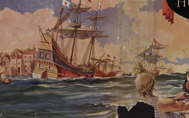
The establishment of this view, however, only makes With's (or White's, as the English translation of Hackluyt expresses it) drawing, “The Arrival of the English in Virginia,” all the more certainly a picture of the landing of Barlowe's expedition, as will presently appear, for the boat with the eight or nine men in it is plainly sailing from Trinity Harbor south-west toward Roanoke Island and the Indian village at the north end of it, while the record of the landing of Grenville and Lane sets forth with equal explicitness that they came through “Hatorask.” But whatever apparent confusion there is as to names, the records plainly indicate that the early explorers from 1585 to 1590 all headed for an inlet or harbor “well known to our English,” near Roanoke Island, called “Hatorask.” The name Trinity Harbor, which only appears in DeBry's maps, may have been an after-thought with the pious Hariot, who aided in their preparation, or it may have been given by the expedition of 1584 to denote the religious purpose which our explorers, as well as others of that time, had, or thought they had, in taking possession of our shores. In the prow of the boat shown on the drawing entitled “The Arrival of the English in Virginia,” stands a man holding out a cross toward the island and the village. This picture, as painted by John With (White), doubtless serves well the purpose of representing the arrival of either Amidas and Barlowe, or of Grenville and Lane in the year following,
or both. They both came to the island through Hatorask Banks and may well have come through the same inlet. The explanation of this drawing was put into Latin by Hackluyt, and the books containing the drawing have come down to us with the explanations. The Latin (edition of 1590), as accurately translated, says: “* * * Entering, therefore, the inlet and purusing our navigation a little way, we observed a great river making its way out of this region of the aforesaid islands [the coastal islands constituting the banks already mentioned in the explanation], which, however, we could not ascend by reason of its narrowness and the heaps of sand which obstructed its mouth.” The old English reads: “After wee had passed opp and sayled ther in for a short space wee discovered a myghtie riuer falling downe into the Sounde over against those ilands, which, nevertheless, wee could not sayle opp anything far by reason of the shallewnes, the mouth ther of beinge annoyed with sands driven in with the tyde.” The Latin evidently described Currituck Sound, but the English also fits the Albemarle, as represented on DeBry's maps, with a bar across its mouth. While the illustration represents the first coming of the English to Roanoke, and perhaps as well also the second, the explanations, both in English and Latin, appear to be mainly descriptive of the second landing on the island which both White and Hariot saw with their own eyes, and the latter doubtless instructed Hackluyt abount Virginia as he did DeBry. Barlowe says that his expedition entered into the first inlet that appeared unto them, while Grenville experimented with inlets all the
way from the region of Cape Lookout to the Hatorask Harbor. If White only made the drawing and Hariot or Hackluyt was the author rather than the mere translator and editor of the descriptions, we can see why he added incidents which did not occur at the first landing. The painter appears to have been using the second landing, which he saw, to aid him in describing the first, which he did not see; for if he meant to represent the second “Coming of the English into Virginia,” he would, it seems, have painted the banks and inlet at Wokokon, through which Lane entered Virginia several days before he came to Roanoke Island. Perhaps Hariot or Hackluyt, who may not have had Barlowe's account before him, thought the explanations fitted, or could be made to fit, both landings at Roanoke as well as the drawing. At any rate the old English (see the translation appended hereto) left out what the Latin contains: “At length we found a certain entrance well known to our English.” This sentence makes the Latin explanation more naturally, but not necessarily, refer to the second landing, the knowledge of the inlet having been gained through the first expedition. There are other incidents described alike in the English and the Latin which also make the explanation refer to the second landing, though, as above hinted, Hariot (or whoever edited the explanations of the drawings which were supposed to have been written by DeBry or the painter himself) may not have had Barlowe's account before him, and perhaps could not compare the details of his landing and the different receptions given by the Indians to the two expeditions.
However these things may be, a casual glance at the drawing itself shows that its perspective is altogether from the stand-point of ships anchored off an inlet about twenty miles north-east of Roanoke Island. From this inlet the explorations are shown to extend about the same distance in the three directions they covered—north, west and south—just about the territory explored by the expedition of 1584. (Lane's covered more than a hundred miles in every direction). Even Currituck Sound, which they could not ascend with the boat they were in, is shown almost in its entirety, and appears wider even than the Albemarle, only the west end of which is outlined, while of the Pamlico just enough appears to show the setting of the island.
The three towns given are Roanoac, Dasamonguepeuk, “four or five miles” west of it, and Pasquenoke, a little further to the west on the north shore of the Albemarle; while Pomeioc, about twenty miles south of Roanoke Island, is not shown at all, though it would have been the nearest town and the one logically they would have first entered if they had come in twenty miles south of the island. The inlets shown are all opposite to or north of the island; nothing appears clearer than that the artist did not regard Pamlico Sound as forming any essential part of his picture; and the picture is a travesty on what it represents, unless the coming in was from an inlet north of the island.
Barlowe's narrative, carefully considered, is hardly less conclusive. It says: “After they [the Indians] had been divers times on board the ships, myself with seven more went
about twenty miles into the river that runs towards Skicoak [a town represented on DeBry's map to be near one of the tributaries of the Chesapeake and not far from the upper Chowan], which river they call Occam; and the evening following we came to an island which they call Roanoke, distant from the harbor by which we entered seven leagues.” The account of Drake's voyage speaks of proceeding to a “place they [Lane's colony] called their port,” the “road” of which was “about six leagues” from Lane's “fort,” in an “island which they call Roanoac.” This fixes the distance of the inlet, supposing they both used the same, at six or seven leagues. Barlowe continues: “Beyond this island there is a mainland, and over against this island falls into this spacious water [the water in which the island was situated] the great river called Occam by the inhabitants, on which stands a town called Pomeioc, and six days’ journey from the same is situated their greatest city, called Skicoak. * * * Into this river falls another great river called Cipo, in which there is found a great store of muscles in which there are pearls. Likewise there descendeth into this Occam another river called Nomopana [which is Occam extended toward Skicoak], on one side whereof stands a great town called Chawanook.” The great river Occam is the Albemarle Sound; the Nomopana, on which was the town of Chawanook (afterwards ascertained to be a country containing eighteen towns), was what is now called the Chowan River; Cipo was the Roanoke River. The Albemarle falls into the “spacious water” in which, or at the head of which, Roanoke Island is situated, and upon which
the record doubtless intended to say Pomeioc was situated, for otherwise we would be forced to extend the river Occam twenty miles below Roanoke Island, unless the narrator confuses this name with the country (Weapomeioc) on the north shores of the Albemarle.
Another point that may be noted, is that the banks about twenty miles north of Roanoke Island are still about “six miles” wide.
To show that Cipo is the Roanoke, the “great river” (in the language of Barlowe) that falls into Occam, it may be noted that it pours about as much water into the Albemarle as all its other tributaries combined. Lane (in 1586) thus describes it: “* * * Directly from the west runs a most notable river called the Moratok [doubtless so-called from the “principal Indian town” of the same name on its north bank.] This river opens into the broad sound of Weapomeiok [the name by which Lane called the Albemarle Sound and the country north of it.] And whereas, the river of Chawanook, and all the other sounds and bays, salt and fresh, shew no current in the world in calm weather, but are moved altogether with the wind; this river of Moratoc has so violent a current from the west and south-west that it made me almost of opinion that with oars it would scarce be navigable; it passes with many creeks and turnings, and for the space of thirty miles’ rowing and more it is as broad as the Thames betwixt Greenwich and the Isle of Dogs, in some places more, and in some less; the current runs as strong, being entered
so high into the river, as at London bridge upon a vale water.”
Nomopana, the beautiful name of the Chowan, was lost to Lane's expedition, but the “Chawanoke” country on the upper Chowan was explored and duly located on DeBry's map; this substantiates the conclusion that the Occam of Barlowe's expedition was the Albemarle Sound, “the great river” into which Barlowe sailed twenty miles before he came to Roanoke Island. Cipo and Nomopana being fixed as its principal tributaries also identifies it with that sound. The sound once indentified, fixes the location of the inlet through which Amidas and Barlowe sailed, and so fixes the spot of ground on the south side of that inlet upon which the expedition of 1584 landed and took possession of “in the right of the Queen's most Excellent Majesty as rightful Queen and Princess of the same.” John With's (White's) picture, therefore, represents an event second in importance only to the discovery of America.
Barlowe's language is: “Beyond this island there is the mainland”—referring, doubtless, to Dasamonguepeuk, the land immediately west of the island across Croatan Sound—for if they had been coming up from the south they would have been sailing up along the continent for about twenty miles before they came to Roanoke Island, and the waters of the Albemarle Sound (instead of the “mainland”) would have been “beyond” it.
Again: “Beyond this island called Roanoke are many main islands [those along the shores of the mainland] * * *
together with many towns and villages along the side of the continent.” * * * DeBry's map of Lane's expedition gives seventy-six islands, ten of which are “out-islands” (the banks), and sixty-six of which are within the sounds—one in the Albemarle, one where the waters of the Albemarle and Currituck come together; the others, except those in Currituck Sound, are all in the Pamlico, unless we except the few small ones in Croatan Sound. Those in Currituck are not referred to because they are not “together with many towns and villages,” for no towns and villages are mentioned in any of the maps or records as being on this sound; therefore those referred to must be “beyond” Roanoke Island to discoverers coming in from the north-east. In the Pamlico Sound were shown on DeBry's map numerous islands and many points and peninsulas which might have been readily mistaken for them.
Nor does the concluding portion of Barlowe's narrative conflict with the interpretation above given: “When we first had sight of this country some thought the first land we saw to be the continent, but after we entered into the haven we saw before us another mighty long sea [the water which expands through all its sounds fifty miles north and one hundred and fifty miles south of Trinity Harbor]; for there lieth along the coast a tract of island two hundred miles in length, adjoining to the ocean sea, and between the islands two or three entrances; when you are entered between them (these islands being very narrow for the most part, as in most places six miles broad, in some places less, in few more) then
there appeared another great sea, containing in breadth, in some places, forty, and in some fifty, in some twenty miles over, before you come unto the continent, and in this enclosed sea there are above a hundred islands of divers bignesses, whereof one is sixteen miles long [Roanoke Island], at which we were, finding it a most pleasant and fertile ground.” * *
DeBry's map shows eleven inlets or “entrances,” so, as Barlowe expressly limits the number to “two or three,” it shows that he had only examined those next to Roanoke Island—Trinity Harbor, Hatorask and one between them.
One purpose of this discussion is to show the value of White's drawing as an historic representation of the taking possession of this continent by the English in 1584—though it is hardly less valuable if it only represents the landing of 1585. It is passing strange that no reproduction of it on a great scale, such, for example, as the painting on the dropcurtain in the Music Hall of the Olivia Raney Library, has ever been made, either for the State, the nation or the English-speaking people, an event in which all are interested. The artist who will reproduce, on a scale proportioned to the event, in living colors, this drawing of John White, the painter selected by Queen Elizabeth herself, will discharge a duty to his country and his race; will represent the most interesting picture connected with American history, and will show that North Carolina contains the spot on which formal possession of the continent was taken by the English race.
Below is given a representation of the drawing, together with the explanations in old English and a recent translation
of the original Latin; also the joint preface of DeBry and Hackluyt to the Hackluyt's translation in DeBry's “True Pictures, etc., of Virginia,” and the title-page and an extract of Hariot's “Briefe Report”—all tending to throw light on the “discoveries of the new found land in Virginia”—North Carolina.
THE ARRIUAL OF THE ENGLISHEMEN IN VIRGINIA. (From DeBry's “True Pictures, etc., of Virginia.”)*The sea coasts of Virginia arre full of Ilands, wher by the entrance into the mayne land is hard to finde. For although they bee separated with diuers and sundrie large Diuisions, which seeme to yeeld conuenient entrance, yet to our great perill we proued that they wear shallowe, and full of dangerous flatts, and could never perce opp into the mayne land, until wee made trialls in many places with or small pinness. At lengthe wee fownd an entrance vpon our mens diligent serche thereof. Affter that we had passed opp, and sayled ther in for a short space we discouered a mightye riuer fallinge downe into the sownde ouer against those Ilands, which neuertheless wee could not saile opp any thing far by Reason of the shallewnes, the mouth ther of beinge annoyed with sands driuen in with the tyde; therefore sayling further, wee came vnto a Good bigg yland, the Inhabitants thereof as soone as they saw vs began to make a great and horrible crye, as people which neuer befoer had seene men apparelled like vs,
*Hariot also made a translation from the Latin into English.and came away makinge out crys like wild beasts or men out of their wyts. But beenge gentlye called back, we offered them of our wares, as glasses, kniues, babies (dolls), and other trifles, which wee thougt they deligted in. Soe they stood still, and perceuinge our Good will and courtesie, cam fawninge vpon vs and bade us welcome. Then they brougt vs to their village in the iland called Roanoac, and vnto their Weroans or Prince, which entertained vs with Reasonable curtesie, althoug they wear amased at the first sight of vs. Suche was our arriuall into the parte of the world which we call Virginia, the stature of bodye of wich people, theyr attire, and maneer of liuinge, their feasts, and banketts, I will particullerlye declare vnto yow.
THE COMING OF THE ENGLISH TO VIRGINIA.(From a recent translation of the Latin of DeBry's “True Pictures, etc., of Virginia.”)
The coasts of Virginia abound (are fringed) with islands which afford quite a difficult approach (entrance) to that region, for although they are separated from one another by numerous and wide intervals (inlets) which seem to promise a convenient entrance, still to our great cost we found them to be shallow and infested with breakers, nor were we ever able to penetrate into the inner places (sounds) until we made trials in many different places with a smaller boat. At length we found an entrance in a certain place well known
to our English. Having therefore entered and continuing our voyage for a considerable distance, we encountered a large river emerging from the region of the aforesaid islands, which, however, it was not possible to enter on account of the narrowness (of its channel), as the sands filled its mouth (lt: a bar of sand filling its mouth). Therefore, continuing our voyage, we arrived at a large island, whose inhabitants upon the sight of us began to raise a great and awful outcry, because (forsooth) they had never beheld men like unto us, and taking headlong to flight, they filled all places with their yells after the manner of wild beasts or madmen. But being recalled by our friendly overtures, and our wares having been displayed, such as mirrors, small knives (dolls), and other trinkets which we thought would be pleasing to them, they halted, and, having observed our friendly disposition, they became amicable and showed pleasure at our arrival. Afterwards they conducted us to their town called Roanoac and to their Weroans, or chief, who received us very courteously, though (evidently) astonished at our appearance.
Such was our arrival in that part of the new world which we call Virginia.
I shall describe to you by illustrations (drawings and pictures) the figures of the inhabitants, their ornaments, manner of living, festivities and feasts.
TITLE-PAGE OF DeBRY'S “TRUE PICTURES, ETC., OF VIRGINIA.”
THE TRVE PICTVRES AND FASHIONS OF THE PEOPLE IN THAT PARTE OF AMERICA NOVV CALLED VIRGINIA, DISCOWRED BY ENGLISMEN sent thither in the years of our Lorde 1585. att the speciall charge and direction of the Honourable Sir Walter Ralegh Knight Lord Warden of the stannaries in the duchies of Corenwal and Oxford who therein hath bynne fauored and auctorifed by her Maaiestie and her letters patents.
Translated out of Latin into English by RICHARD HACKLVIT.
vignette
DILIGENTLYE COLLECTED AND DRAOWne byIhon Whitewho was sent thiter speciallye and for the same purpose by the saidSir Walter Raleghthe year aboue said 1585. and also the year 1588. now cutt in copper and first published by THEODORE de BRY att his wone chardges.
EXTRACT TRANSLATED FROM THE LATIN OF DeBRY'S INTRODUCTION TO THE “TRUE PICTURES, ETC., OF VIRGINIA.”“I have determined to present in this book true representations of them [the Indians] which (with the assistance of Richard Hackluyt of Oxford, a servant of God's Word, who was in that region and was the adviser that this work should be published), I have copied from a prototype imparted to me by John With, an English painter who was sent into that same region of her Majesty, the Queen of England, for the express purpose of making its topography and representing, according to life, the form of its inhabitants, their dress, mode of life and customs—by means of the no small outlay of the noble Knight, Sir Walter Raleigh, who has expended very much in examining and exploring that region from the year 1585 to the end of the year 1588. * * * I and my children have devoted ourselves diligently to engraving and rendering of the figures into copper whenever the matter is of sufficient importance.”
TITLE-PAGE OF HARRIOT'S “VIRGINIA.”
A BRIEFE AND TRUE REPORT OF THE NEW FOUND LAND OF VIRGINIA: OF the commodities there found and to be raysed, as well marchantable, as others for victuall, building and other necessarie uses for those that are and shalbe the planters there; and of the nature and manners of the naturall inhabitants: Discouered by the English Colony there seated by Sir Richard Greinvile Knight in the yeere 1585. which remained vnder the gouernment of Rafe Lane Esquier, one of her Maiesties Equieres, during the space of twelue monethes: at the special charge and direction of the Honourable SIR WALTER RALEIGH Knight, Lord Warden of the stanneries; who therein hath beene fauoured and authorised by her Maiestie and her letters patents:
DIRECTED TO THE ADUENTURERS, FAUOURERS, and Welwillers of the action, for the inhabiting and planting there:
By Thomas Hariot; seruant to the abounamed Sir Walter, a member of the Colony, and there imployed in discouering.
vignette
Imprinted at London 1588.
EXTRACT FROM THE INTRODUCTION TO HARIOT'S “VIRGINIA.”TO THE ADUENTURERS, FAUORERS, AND WELWILLERS OF THE ENTERPRISE FOR THE INHABITING AND PLANTING IN VIRGINIA.
Since the first vndertaking by Sir Walter Raleigh to deale in the action of discouering of that Countrey which is now called and known by the name of Virginia; many voyages having bin thither made at sundrie times to his great charge; as first in the yeere 1584, and afterwards in the yeeres 1585, 1586, and now of late this last yeare of 1587: There haue bin diuers and variable reports with some slaunderous and shamefull speeches bruited abroade by many that returned from thence. Especially of that discouery which was made by the Colony transported by Sir Richard Greinuile in the yeare 1585, being of all the others the most principal and as yet of most effect, the time of their abode in the countrey beeing a whole yeare, when as in the other voyage before they staied but sixe weeks; and the others after were onelie for supply and transportation, nothing more being discouered then had been before. * * * * * * * * * * *
I have therefore thought it good beeing one that have beene in the discoveries and in dealing with the naturall inhabitants specially imploide, etc.