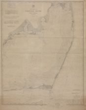
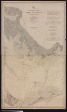
Pamplico Sound, North Carolina. Middle sheet.
- Title
- Pamplico Sound, North Carolina. Middle sheet.
- Description
- Washington : The Survey, 1883. 1 map. 1:80,000. "Price 50 cents."; "Issued August 1883, J.E. Hilgard, Superintendent. Verified R.D. Cutts, Assistant in charge of Office."; Soundings expressed in fathoms at sea, in feet within the coastline.; Includes location of significant lighthouses.; "Plate no. 1790.".The Survey
- Date
- 1883
- Extent
- 80cm x 104cm
- Local Identifier
- G3902.P34 1883 U67
- Creator(s)
- Subject(s)
- Permalink
- https://digital.lib.ecu.edu/10805
- Preferred Citation
- Cite this item
- This item
-
 Pamplico Sound, North Carolina. Middle sheet.
- My Collections Login
- Printable Feedback Form
Related Search Results
Public access is provided to these resources to preserve the historical record. The content represents the opinions and actions of their creators and the culture in which they were produced. Therefore, some materials may contain language and imagery that is outdated, offensive and/or harmful. The content does not reflect the opinions, values, or beliefs of ECU Libraries.
Contact Digital Collections
If you know something about this item or would like to request additional information, click here.
Comment on This Item
Complete the fields below to post a public comment about the material featured on this page. The email address you submit will not be displayed and would only be used to contact you with additional comments or questions.