Survey of Bath Town Creek


[page 28]

[survey map]

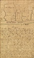
Surveyed for John Killingsworth & James Hodge a piece or parcel of land on the North side of the Pamlico River & West side of Bath Town Creek & near the mouth there, of beginning at James Beard's corner tree, formerly Wm Clark's now Aaron Windley's corner at a pine stump at letter a. Running with said Windley's line N. 80 E. 160 po. [poles] to the head of a small creek or branch at letter b. thence with the said creek to the main creek at letter c. thence down the creek to another small creek at letter d. which is Vines' now Wm. L. Kennedy's & Welsh's corner at letter e. thence N. 8 1/2 E. 190 po. to the first station. Containing 495 1/2 acres. the courses & distances are S. 49 E. 31 po. S. 45 E 16 po. S 47 E. 20 po. N. 88 E. 20 po. S. 76 E. 28 po. S. 10 W. 4 po. S. 75 E. 18 po[.] S. 85 E. 16 po. N. 85 E. 12 po. S. 78 E. 12 po. S. 19 W. 12 po. N. 76 E. 12 po. S. 82 E. 20 po. S. 42 E.10 po. S. 5 E. 24 po. Thence S. 62 E. 19 po. To the Creek. the boundaries f. b. c. h. g. containing 115 1/2 Acres are laid off and allotted to Mr. Hod[ge].


[page 29]

Surveyed January 18th and 20th A. [Anno] 1840.

Daniel Windley & John Killingsworth Chain Bearers.

A Copy

William Clark

To

Moses Windley

19th September 1797

305 Acres on the North side of Pamtico River & West side of Bath Town Creek[.] Beginning at a small creek that parts him from John Nelson. Running up that small creek to a line in the Savannah S. 80 W. 160 po. through the Savannah to another pine that parts him from the Glebe N.E. 36 d. 164 po. Thence down to the Glebe Creek S. E. 54 d. 160 po. Then down the creek to the first section.

The above was granted 375 Acres to James Beard 26th Sept. 1722, but he dying intestate and leaving no Representative, it was Escheated and subsequently granted to John Lovick in 1723.


Title
Survey of Bath Town Creek
Description
Land survey showing the Bath Town Creek and adjacent land. From early on, Bath was defined by land transactions. The following is a mid-nineteenth-century survey of lands that includes mention of eighteenth-century ownership of the land going back to 1722. The Glebe Land (land owned by St. Thomas Episcopal Church to help support the minister) is directly across from the town of Bath.
Date
January 18, 1840
Original Format
maps
Extent
Local Identifier
0472-001-b1
Subject(s)
Spatial
Location of Original
East Carolina Manuscript Collection
Rights
This item has been made available for use in research, teaching, and private study. Researchers are responsible for using these materials in accordance with Title 17 of the United States Code and any other applicable statutes. If you are the creator or copyright holder of this item and would like it removed, please contact us at als_digitalcollections@ecu.edu.
http://rightsstatements.org/vocab/InC-EDU/1.0/
Permalink
https://digital.lib.ecu.edu/10514
Preferred Citation
Cite this item
Content Notice

Public access is provided to these resources to preserve the historical record. The content represents the opinions and actions of their creators and the culture in which they were produced. Therefore, some materials may contain language and imagery that is outdated, offensive and/or harmful. The content does not reflect the opinions, values, or beliefs of ECU Libraries.

Contact Digital Collections

If you know something about this item or would like to request additional information, click here.


Comment on This Item

Complete the fields below to post a public comment about the material featured on this page. The email address you submit will not be displayed and would only be used to contact you with additional questions or comments.


*
*
*
Comment Policy