E. A. Bradford vs. S. C. Payne, et. al.map of survey by order of court showing disputed lands in the above entitled case.
- Title
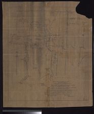
- E. A. Bradford vs. S. C. Payne, et. al.map of survey by order of court showing disputed lands in the above entitled case.
- Description
- Moore County, N.C. : Superior Court, 1901. 1 map : ms.. Scale [1:7920]. 10 chains=1 in. "Notes of survey A, B, C, D, E, F, G, H, I, J, represents location of 350 acres divided for Mrs. C.H. Womble. K. L. M. N, O, P, Q, R, S, T, U, V, W, X, Y, Z, AA, BB, CC, represents location of plaintiffs claim embraced in B.N. Watson deed. DD, EE, FF, GG location of 2 acre lot owned by plaintiffs. HH, II, JJ, KK soapstone mine tract claimed by defendants. Surveyed May, 1901. Francis Denton, County Surveyor.".Superior Court
- Date
- 1901
- Extent
- Local Identifier
- G3903.M9 1901 .N67
- Creator(s)
- Contributor(s)
- Subject(s)
- Permalink
- https://digital.lib.ecu.edu/10445
- Preferred Citation
- Cite this item
- This item
-
 E. A. Bradford vs. S. C. Payne, et. al.map of survey by order of court showing disputed lands in the above entitled case.
- My Collections Login
- Printable Feedback Form
Public access is provided to these resources to preserve the historical record. The content represents the opinions and actions of their creators and the culture in which they were produced. Therefore, some materials may contain language and imagery that is outdated, offensive and/or harmful. The content does not reflect the opinions, values, or beliefs of ECU Libraries.
Contact Digital Collections
If you know something about this item or would like to request additional information, click here.
Comment on This Item
Complete the fields below to post a public comment about the material featured on this page. The email address you submit will not be displayed and would only be used to contact you with additional comments or questions.