New and Correct Map of the Province of North Carolina
- Title
- New and Correct Map of the Province of North Carolina
- Description
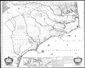
- A New and Correct Map of the Province of North Carolina by Edward Moseley, late surveyor general of the said province ([London]: Sold at the Three Crowns, 1733). Shows settlements, inhabitants, soil conditions, rivers, and principal products, with insets showing Port Brunswick or Cape Fear Harbour, Port Beaufort or Topsail Inlet, Ocacock [Ocracoke] Inlet, Explanation, and Directions for Ocacock [Ocracoke] Inlet. (This image was assembled from 6 separate scans of the original map)
- Extent
- Local Identifier
- MC0017...
- Permalink
- https://digital.lib.ecu.edu/62316
- Preferred Citation
- Cite this item
- This item
-
 New and Correct Map of the Province of North Carolina
- My Collections Login
- Printable Feedback Form
Public access is provided to these resources to preserve the historical record. The content represents the opinions and actions of their creators and the culture in which they were produced. Therefore, some materials may contain language and imagery that is outdated, offensive and/or harmful. The content does not reflect the opinions, values, or beliefs of ECU Libraries.
Contact Digital Collections
If you know something about this item or would like to request additional information, click here.
Comments
Reproductions of this map are sold online, at http://www.ecu.edu/cs-lib/giving/maps.cfm
Reiterating comment 2, can I purchase a copy of this map anywhere?Thank you, Laurie Chapman
I think i hold the original copy 9f this map an if so what is its value
If you do then it would only be right to make sure it ends up at ecu so they can file it. The value of it is priceless as this is part of history and you shouldn’t try to sell this
How can I obtain a printed paper copy of this map? U83es
Unfortunately, the original map seems to have sustained fold damage, which can be seen on the original 4 negatives, and is not an alignment problem.
Could you possibly upload this again as it appears that there was some alignment problems during your piecing it together. Core Banks just north of Cape Lookout is particularly out of whack. Thanx...
Is there a much higher resolution version of this map online somewhere, so the detail information can be read online? If not, please consider adding this to your collection.
Comment on This Item
Complete the fields below to post a public comment about the material featured on this page. The email address you submit will not be displayed and would only be used to contact you with additional questions or comments.
The download button merely opens the map in a new window. It doesn't actually download the file. I'd really like to have a full-scale digital version of this map. Is that possible through this web site?