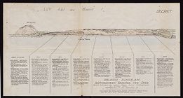
Beach diagram : Southeastern beaches, Iwo Jima
- Title
- Beach diagram : Southeastern beaches, Iwo Jima
- Description
- Beach information taken from aerial photographs of 4 July 1944. Appendix 7 to Annex B. Prepared by Intelligence Section, Amphibious Forces Pacific and A.C. of S. G-2, Fleet Marine Forces Pacific. Marked "secret."
- Date
- 1944
- Original Format
- maps
- Extent
- 46cm x 24cm
- Local Identifier
- MC0014-001
- Creator(s)
- Subject(s)
- World War, 1939-1945--Campaigns--Japan--Iwo Jima (Volcano Islands)
- Iwo Jima (Volcano Islands, Japan)--Maps
- Beaches--Japan--Iwo Jima (Volcano Islands)
- Spatial
- Location of Original
- East Carolina Manuscript Collection
- Rights
-
This item has been made available for use in research, teaching, and private study. Researchers are responsible for using these materials in accordance with Title 17 of the United States Code and any other applicable statutes. If you are the creator or copyright holder of this item and would like it removed, please contact us at als_digitalcollections@ecu.edu.
http://rightsstatements.org/vocab/InC-EDU/1.0/ - Permalink
- https://digital.lib.ecu.edu/14830
- Preferred Citation
- Cite this item
- This item
-
 Beach diagram : Southeastern beaches, Iwo Jima
- My Collections Login
- Printable Feedback Form
- Found in theme/project
-
 Military History
-
 Military History: Navy
-
 Military History: World War II
- Location of Original
- Beach Diagram of Southeastern beaches at Iwo Jima from the East Carolina Manuscript Collection
- View all digitized items from the Beach Diagram of Southeastern beaches at Iwo Jima
Public access is provided to these resources to preserve the historical record. The content represents the opinions and actions of their creators and the culture in which they were produced. Therefore, some materials may contain language and imagery that is outdated, offensive and/or harmful. The content does not reflect the opinions, values, or beliefs of ECU Libraries.
Contact Digital Collections
If you know something about this item or would like to request additional information, click here.
Comment on This Item
Complete the fields below to post a public comment about the material featured on this page. The email address you submit will not be displayed and would only be used to contact you with additional questions or comments.